
Tập tin:North German Confederation 1870.svg

Kích thước bản xem trước PNG này của tập tin SVG: 450×456 điểm ảnh. Độ phân giải khác: 237×240 điểm ảnh | 474×480 điểm ảnh | 758×768 điểm ảnh | 1.011×1.024 điểm ảnh | 2.021×2.048 điểm ảnh.
Tập tin gốc (tập tin SVG, 450×456 điểm ảnh trên danh nghĩa, kích thước: 705 kB)
Tập tin này từ Wikimedia Commons. Trang miêu tả nó ở đấy được sao chép dưới đây. Commons là kho lưu trữ tập tin phương tiện có giấy phép tự do. Bạn có thể tham gia. |
Miêu tả
This W3C-unspecified vector image was created with Inkscape .


.svg)
.svg)
.svg)
.svg)
.svg)


.svg)
.svg)
.svg)


.png)
.png)


.svg)


.svg)

.svg)


.svg)
.svg)
.svg)
.svg)


.svg)
.png)


.svg)


.svg)
.svg)


.svg)


.svg)


.svg)
.svg)
.svg)
.svg)
.svg)
.svg)
.svg)
_cropped.svg)
.svg)
.svg)
.svg)
.svg)
.svg)
.svg)
.svg)
.svg)
.svg)
.svg)
.svg)
.svg)
.svg)
.svg)
.svg)
.svg)
.svg)
.svg)
.svg)
.svg)
.svg)
.svg)
.svg)
.svg)
.svg)
.svg)
.svg)
.svg)
.svg)
.svg)
.svg)
.svg)
.svg)
.svg)
.svg)
.svg)
.svg)
.svg)
.svg)
.svg)
.svg)
.svg)
.svg)
.svg)
.svg)
Giấy phép
Tập tin này được phát hành theo Giấy phép Creative Commons Ghi công–Chia sẻ tương tự 4.0 Quốc tế.
- Bạn được phép:
- chia sẻ – sao chép, phân phối và chuyển giao tác phẩm
- pha trộn – để chuyển thể tác phẩm
- Theo các điều kiện sau:
- ghi công – Bạn phải ghi lại tác giả và nguồn, liên kết đến giấy phép, và các thay đổi đã được thực hiện, nếu có. Bạn có thể làm các điều trên bằng bất kỳ cách hợp lý nào, miễn sao không ám chỉ rằng người cho giấy phép ủng hộ bạn hay việc sử dụng của bạn.
- chia sẻ tương tự – Nếu bạn biến tấu, biến đổi, hoặc làm tác phẩm khác dựa trên tác phẩm này, bạn chỉ được phép phân phối tác phẩm mới theo giấy phép y hệt hoặc tương thích với tác phẩm gốc.
Lịch sử tập tin
Nhấn vào ngày/giờ để xem nội dung tập tin tại thời điểm đó.
| Ngày/giờ | Hình xem trước | Kích cỡ | Thành viên | Miêu tả | |
|---|---|---|---|---|---|
| hiện tại | 02:58, ngày 1 tháng 6 năm 2016 | | 450×456 (705 kB) | Alphathon | Various corrections to the states of the North German Confederation |
| 05:22, ngày 31 tháng 5 năm 2016 |  | 450×456 (662 kB) | Alphathon | Uploaded wrong file | |
| 05:22, ngày 31 tháng 5 năm 2016 |  | 450×456 (725 kB) | Alphathon | Minor corrections (Tarasp and post-1818 German Confederation border change) | |
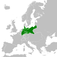
| 02:40, ngày 31 tháng 5 năm 2016 |  | 450×456 (662 kB) | Alphathon | == {{int:filedesc}} == {{Inkscape}} {{Information |Description={{en|A map of the en:North German Confederation within Europe circa 1870 CE.}} |Source= {{Derived from|Blank_map_of_Europe.svg|display=50}} |Date=2016-05-31 |Author=*[[:File:Bla... |
Trang sử dụng tập tin
Có 1 trang tại Wikipedia tiếng Việt có liên kết đến tập tin (không hiển thị trang ở các dự án khác):
Sử dụng tập tin toàn cục
Những wiki sau đang sử dụng tập tin này:
- Trang sử dụng tại ang.wikipedia.org
- Trang sử dụng tại ar.wikipedia.org
- Trang sử dụng tại azb.wikipedia.org
- Trang sử dụng tại bg.wikipedia.org
- Trang sử dụng tại cs.wikipedia.org
- Trang sử dụng tại en.wikipedia.org
- Trang sử dụng tại es.wikipedia.org
- Trang sử dụng tại eu.wikipedia.org
- Trang sử dụng tại fa.wikipedia.org
- Trang sử dụng tại fi.wikipedia.org
- Trang sử dụng tại fr.wikipedia.org
- Trang sử dụng tại he.wikipedia.org
- Trang sử dụng tại hr.wikipedia.org
- Trang sử dụng tại is.wikipedia.org
- Trang sử dụng tại it.wikipedia.org
- Trang sử dụng tại ko.wikipedia.org
- Trang sử dụng tại lt.wikipedia.org
- Trang sử dụng tại lv.wikipedia.org
- Trang sử dụng tại ms.wikipedia.org
- Trang sử dụng tại pl.wikipedia.org
- Trang sử dụng tại pt.wikipedia.org
- Trang sử dụng tại ru.wikipedia.org
- Trang sử dụng tại sv.wikipedia.org
- Trang sử dụng tại th.wikipedia.org
- Trang sử dụng tại tr.wikipedia.org
- Trang sử dụng tại zh.wikipedia.org