
Tập tin:Mount Rainier Hazard Map-en.svg

Kích thước bản xem trước PNG này của tập tin SVG: 501×599 điểm ảnh. Độ phân giải khác: 201×240 điểm ảnh | 401×480 điểm ảnh | 642×768 điểm ảnh | 856×1.024 điểm ảnh | 1.713×2.048 điểm ảnh | 1.059×1.266 điểm ảnh.
Tập tin gốc (tập tin SVG, 1.059×1.266 điểm ảnh trên danh nghĩa, kích thước: 2,46 MB)
Tập tin này từ Wikimedia Commons. Trang miêu tả nó ở đấy được sao chép dưới đây. Commons là kho lưu trữ tập tin phương tiện có giấy phép tự do. Bạn có thể tham gia. |
Miêu tả
| Miêu tả |
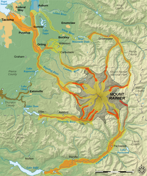
English: Hazard map around the Mount Rainier, state of Washington, United States.
Lava flow and pyroclastic flows
Electron Mudflow-sized event (generally large in size)
National Lahar-sized event (generally moderate in size)
Lahars not necessarily associated to volcanism (generally small)
Flooding after lahar event
Potential area of inundation from failure of Alder Dam
County boundary
Mount Rainier National Park boundary
City Esperanto: Mapo pri riskoj ĉirkaŭ Monto Rainier, Vaŝingtonio, Usono.
Lafa fluo kaj piroklastaj fluoj
Grandskalaj laharoj (tipo "Electron")
Moderaskalaj laharoj (tipo "National")
Laharoj ne certe asociitaj al vulkanaĵoj (ĝenerale malgrandskalaj)
Inundoj post lahara evento
Eventuala inunda regiono okaze de rompiĝo de Digo Alder
Kantona limo
Limo de Nacia Parko Mount Rainier
Urbo Français : Carte des risques liés au volcanisme du Mont Rainier, état de Washington, États-Unis.
Coulées de laves et coulées pyroclastiques
Lahars de grande taille (Type Electron)
Lahars de taille moyenne
Coulées de boues de petite taille (généralement non associées au volcanisme)
Inondations induites par des lahars
Zone potentiellement inondable suite à la rupture du barrage Alder
Limites de comtés
Limites du parc national du mont Rainier
Ville |
||
| Ngày | |||
| Nguồn gốc |
English: Tác phẩm được tạo bởi người tải lên. Data sources :
Softwares used :
Others :
Français : Tác phẩm được tạo bởi người tải lên. Source des données :
Logiciels utilisés :
Données géographiques :
|
||
| Tác giả | Sémhur | ||
| Phiên bản khác |
|
||
| Ghi công (required by the license) | © Sémhur / Wikimedia Commons / | ||
| SVG | W3C-validity not checked. This W3C-unspecified vector image was created with Inkscape .
|
||
| Atelier graphique |

| Vị trí máy chụp hình | | Xem hình này và các hình ảnh lân cận trên: OpenStreetMap |
|---|
Giấy phép
Hình này thuộc phạm vi công cộng tại Hoa Kỳ vì toàn bộ nội dung của nó được lấy từ Cục Khảo sát Địa chất Hoa Kỳ (USGS), một cơ quan thuộc Bộ Nội vụ Hoa Kỳ. Xem chính sách chính thức về bản quyền của USGS để biết thêm thông tin.
|
Lịch sử tập tin
Nhấn vào ngày/giờ để xem nội dung tập tin tại thời điểm đó.
| Ngày/giờ | Hình xem trước | Kích cỡ | Thành viên | Miêu tả | |
|---|---|---|---|---|---|
| hiện tại | 10:18, ngày 20 tháng 12 năm 2007 | | 1.059×1.266 (2,46 MB) | Sémhur | Correcting some labels |
| 11:17, ngày 10 tháng 12 năm 2007 |  | 1.059×1.266 (2,46 MB) | Sémhur | == Picture keys == {{legend|#aaa788|Lava flow and pyroclastic flows}} {{legend|#cdcb54|Electron Mudflow-sized event (generally large in size)}} {{legend|#e59b36|National Lahar-sized event (generally moderate in size)}} {{legend|#e45218|Lahars not necessar |
Trang sử dụng tập tin
Có 1 trang tại Wikipedia tiếng Việt có liên kết đến tập tin (không hiển thị trang ở các dự án khác):
Sử dụng tập tin toàn cục
Những wiki sau đang sử dụng tập tin này:
- Trang sử dụng tại bg.wikipedia.org
- Trang sử dụng tại cs.wikipedia.org
- Trang sử dụng tại da.wikipedia.org
- Trang sử dụng tại de.wikipedia.org
- Trang sử dụng tại el.wikipedia.org
- Trang sử dụng tại en.wikipedia.org
- Trang sử dụng tại en.wikiversity.org
- Trang sử dụng tại eo.wikipedia.org
- Trang sử dụng tại es.wikipedia.org
- Trang sử dụng tại he.wikipedia.org
- Trang sử dụng tại it.wikipedia.org
- Trang sử dụng tại it.wikiversity.org
- Trang sử dụng tại ja.wikipedia.org