
Tập tin:OR-districts-108.JPG
Không có độ phân giải cao hơn.
OR-districts-108.JPG (186×151 điểm ảnh, kích thước tập tin: 5 kB, kiểu MIME: image/jpeg)
Tập tin này từ Wikimedia Commons. Trang miêu tả nó ở đấy được sao chép dưới đây. Commons là kho lưu trữ tập tin phương tiện có giấy phép tự do. Bạn có thể tham gia. |
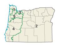
| Miêu tả | Image adapted from US fed gov't source nationalatlas.gov en:Category:Oregon maps | |||
| Nguồn gốc | National Atlas of the United States | |||
| Tác giả | United States Department of the Interior | |||
| Giấy phép (Dùng lại tập tin) |
|
Nhật trình tải lên đầu tiên
Trang miêu tả gốc từng tồn tại ở đây. Tất cả các tên người dùng sau là tên người dùng tại en.wikipedia.
- 2004-02-29 02:15 Seth Ilys 186×151×8 (5367 bytes) {{msg:PD}} Image adapted from US fed gov't source nationalatlas.gov
Lịch sử tập tin
Nhấn vào ngày/giờ để xem nội dung tập tin tại thời điểm đó.
| Ngày/giờ | Hình xem trước | Kích cỡ | Thành viên | Miêu tả | |
|---|---|---|---|---|---|
| hiện tại | 17:06, ngày 4 tháng 12 năm 2006 | | 186×151 (5 kB) | Shyam | {{Information |Description=Image adapted from US fed gov't source nationalatlas.gov en:Category:Oregon maps |Source=Originally from [http://en.wikipedia.org en.wikipedia]; description page is/was [http://en.wikipedia.org/w/index.php?title=Image%3AOR- |
Trang sử dụng tập tin
Có 1 trang tại Wikipedia tiếng Việt có liên kết đến tập tin (không hiển thị trang ở các dự án khác):
Sử dụng tập tin toàn cục
Những wiki sau đang sử dụng tập tin này:
- Trang sử dụng tại ca.wikipedia.org
- Trang sử dụng tại de.wikipedia.org
- Trang sử dụng tại en.wikipedia.org
- Trang sử dụng tại es.wikipedia.org
- Trang sử dụng tại fr.wikipedia.org
- Trang sử dụng tại nl.wikipedia.org