
Tập tin:Brumadinho dam catastrophy 2.jpg
Tập tin gốc (2.400×1.456 điểm ảnh, kích thước tập tin: 5,35 MB, kiểu MIME: image/jpeg)
Tập tin này từ Wikimedia Commons. Trang miêu tả nó ở đấy được sao chép dưới đây. Commons là kho lưu trữ tập tin phương tiện có giấy phép tự do. Bạn có thể tham gia. |
Miêu tả
| Miêu tả |
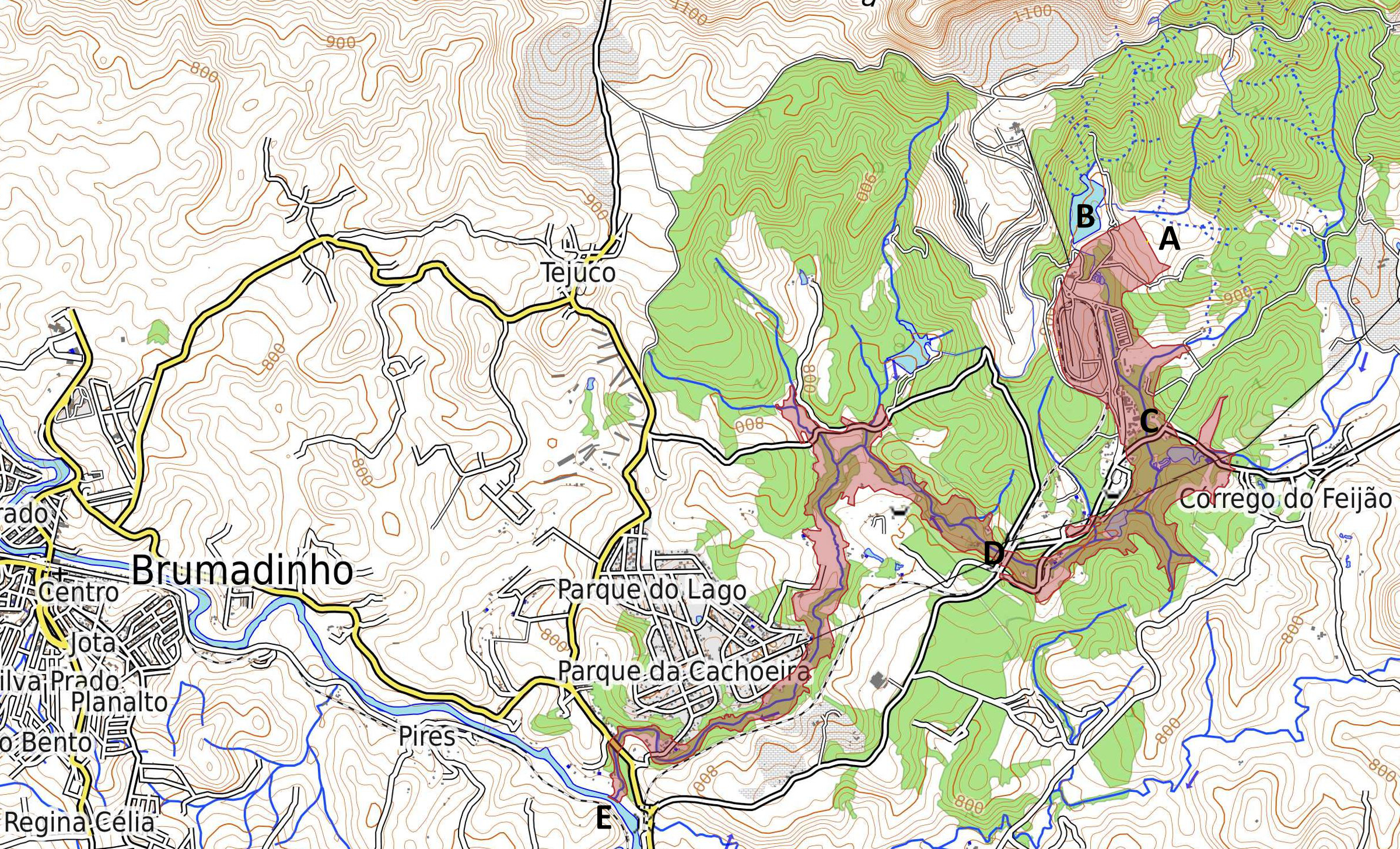
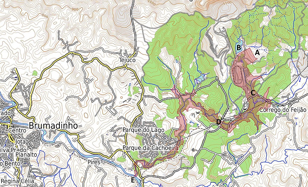
English: Map of tailings dam collapse disaster east of Brumadinho at the Mina Córrego do Feijão. Highlighted in red is the coverage and destruction of the mine dump and debris after the collapse. A Location of destroyed dam and former tailings pond "Barragem I". B Location of second tailings pond "Barragem VI" with destabilized dam, due to the event. C Location of the destroyed office buildings and the cantina of the mine at Vila Ferteco. D Location of the destroyed railway bridge. E Location of the entry point of the mud flood into the river Rio Paraopeba. Português: Mapa da área atingida pelos rejeitos da barragem. A Barragem I - destruída. B Barragem VI - instável. C Vila Ferteco - área administrativa da mina. D Ponte destruída. E Às 15h50min os rejeitos que vazaram da Mina de Feijão atingiram o rio Paraopeba. Deutsch: Karte der Folgen des Dammbruchs bei der Grube Mina Córrego do Feijão östlich des Ortes Brumadinho. In roter Farbe hervorgehoben ist die Bedeckung und Verwüstung durch die Schlammlawine. A Zerstörter Damm des Absetzbeckens "Barragem I". B Benachbartes Absetzbecken "Barragem VI", dessen Damm durch den Vorfall stark beschädigt wurde. C Vila Ferteco - zerstörte Büros und Kantine der Bergbaugesellschaft. D zerstörte Eisenbahnbrücke. E Eintritt der Schlammlawine in den Fluss Paraopeba. |
| Ngày | |
| Nguồn gốc | Map Dataː OpenStreetMap.org contributors. Map styleː OpenTopoMap.org [1] with SRTM data (Shuttle Radar Topography Mission). Shape of mud flow from dam collapseː Sentinel Satellite S2-L1C 2019-01-27 TCI/NDWI/NDVI at sentinel-hub.com via OpenStreetMap.org contributors layer [2] |
| Tác giả | ESA / Copernicus Sentinel-2A-L1C Satellite and OpenStreetMap.org contributors |
Giấy phép
- Bạn được phép:
- chia sẻ – sao chép, phân phối và chuyển giao tác phẩm
- pha trộn – để chuyển thể tác phẩm
- Theo các điều kiện sau:
- ghi công – Bạn phải ghi lại tác giả và nguồn, liên kết đến giấy phép, và các thay đổi đã được thực hiện, nếu có. Bạn có thể làm các điều trên bằng bất kỳ cách hợp lý nào, miễn sao không ám chỉ rằng người cho giấy phép ủng hộ bạn hay việc sử dụng của bạn.
- chia sẻ tương tự – Nếu bạn biến tấu, biến đổi, hoặc làm tác phẩm khác dựa trên tác phẩm này, bạn chỉ được phép phân phối tác phẩm mới theo giấy phép y hệt hoặc tương thích với tác phẩm gốc.

|
This image contains data from a satellite in the Copernicus Programme, such as Sentinel-1, Sentinel-2 or Sentinel-3. Attribution is required when using this image.
Ghi công: Contains modified Copernicus Sentinel data 2019
The use of Copernicus Sentinel Data is regulated under EU law (Commission Delegated Regulation (EU) No 1159/2013 and Regulation (EU) No 377/2014). Relevant excerpts:
Free access shall be given to GMES dedicated data [...] made available through GMES dissemination platforms [...].
Access to GMES dedicated data [...] shall be given for the purpose of the following use in so far as it is lawful:
GMES dedicated data [...] may be used worldwide without limitations in time.
GMES dedicated data and GMES service information are provided to users without any express or implied warranty, including as regards quality and suitability for any purpose. |
Lịch sử tập tin
Nhấn vào ngày/giờ để xem nội dung tập tin tại thời điểm đó.
| Ngày/giờ | Hình xem trước | Kích cỡ | Thành viên | Miêu tả | |
|---|---|---|---|---|---|
| hiện tại | 20:56, ngày 30 tháng 1 năm 2019 | | 2.400×1.456 (5,35 MB) | Agricolax | User created page with UploadWizard |
Trang sử dụng tập tin
Sử dụng tập tin toàn cục
Những wiki sau đang sử dụng tập tin này:
- Trang sử dụng tại cy.wikipedia.org
- Trang sử dụng tại de.wikipedia.org
- Trang sử dụng tại en.wikipedia.org
- Trang sử dụng tại es.wikipedia.org
- Trang sử dụng tại fi.wikipedia.org
- Trang sử dụng tại ga.wikipedia.org
- Trang sử dụng tại he.wikipedia.org
- Trang sử dụng tại hu.wikipedia.org
- Trang sử dụng tại ig.wikipedia.org
- Trang sử dụng tại ja.wikipedia.org
- Trang sử dụng tại mk.wikipedia.org
- Trang sử dụng tại pt.wikipedia.org
- Trang sử dụng tại www.wikidata.org