
Tập tin:Fires along the Rio Xingu, Brazil - NASA Earth Observatory.jpg

Tập tin gốc (1.440×960 điểm ảnh, kích thước tập tin: 329 kB, kiểu MIME: image/jpeg)
Tập tin này từ Wikimedia Commons. Trang miêu tả nó ở đấy được sao chép dưới đây. Commons là kho lưu trữ tập tin phương tiện có giấy phép tự do. Bạn có thể tham gia. |
Miêu tả
| Miêu tả |
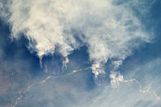
English: The rainforest of South America, also known as Amazonia, has been undergoing a continual and accelerated conversion process into farmlands (including pasture for livestock) since the early 1960s. This process has typically been achieved by clearing the forest using fire—“slash and burn”—followed by planting of crops. The generally infertile soils of this rainforest—the largest such forest on Earth—make sustainable farming difficult. This drives people to convert more forest into farmland. The area of clearing can be considerable, and since the deforested regions are easily identifiable and measurable from space, the rate of deforestation is likewise easy to track.
This astronaut photograph illustrates slash-and-burn forest clearing along the Rio Xingu (Xingu River) in the state of Matto Grasso, Brazil. The photo was taken from the International Space Station, a platform from which astronauts can capture images of the Earth from a variety of viewing angles. The perspective above shows both the horizontal position and the extent of the fire lines next to the river, while also providing a sense of the vertical structure of the smoke plumes. Light colored areas within the river channel are sand bars, which show that the river is in its annual low-flow/low-water stage. For a sense of scale, the river channel is approximately 63 kilometers (39 miles) long in this view. Rivers are the natural highways in Amazonia, which may explain why the burning is occurring right next to the Xingu River, one of Amazonia’s largest. In recent years, forest preservation has gained traction in the region as a result of new valuation of the ecosystem services provided by the forest, concerns about the impact of the burning on global climate change, and greater sensitivity to the ethnic and biological heritage of Amazonia. Astronaut photograph ISS029-E-8032 was acquired on September 17, 2011, with a Nikon D2Xs digital camera using a 200 mm lens, and is provided by the ISS Crew Earth Observations experiment and Image Science & Analysis Laboratory, Johnson Space Center. The image was taken by the Expedition 29 crew. The image has been cropped and enhanced to improve contrast. Lens artifacts have been removed. The International Space Station Program supports the laboratory as part of the ISS National Lab to help astronauts take pictures of Earth that will be of the greatest value to scientists and the public, and to make those images freely available on the Internet. Additional images taken by astronauts and cosmonauts can be viewed at the NASA/JSC Gateway to Astronaut Photography of Earth. Caption by William L. Stefanov, Jacobs/ESCG at NASA-JSC.
|
||||||||||||||||||||||||||||||||||||||||||||||||||
| Ngày | |||||||||||||||||||||||||||||||||||||||||||||||||||
| Nguồn gốc | Fires along the Rio Xingu, Brazil | ||||||||||||||||||||||||||||||||||||||||||||||||||
| Tác giả | NASA's Earth Observatory | ||||||||||||||||||||||||||||||||||||||||||||||||||
| Phiên bản khác |
|
||||||||||||||||||||||||||||||||||||||||||||||||||


| Vị trí máy chụp hình | | Xem hình này và các hình ảnh lân cận trên: OpenStreetMap |
|---|
Giấy phép
- Bạn được phép:
- chia sẻ – sao chép, phân phối và chuyển giao tác phẩm
- pha trộn – để chuyển thể tác phẩm
- Theo các điều kiện sau:
- ghi công – Bạn phải ghi lại tác giả và nguồn, liên kết đến giấy phép, và các thay đổi đã được thực hiện, nếu có. Bạn có thể làm các điều trên bằng bất kỳ cách hợp lý nào, miễn sao không ám chỉ rằng người cho giấy phép ủng hộ bạn hay việc sử dụng của bạn.
| Hình này, ban đầu được tải lên tại Flickr bởi NASA Earth Observatory vào https://www.flickr.com/photos/68824346@N02/6283416535. Tập tin đã được FlickreviewR kiểm tra vào 2 tháng 7 năm 2012 và xác nhận rằng nó tuân theo các điều khoản của cc-by-2.0. |
This file is in the public domain in the United States because it was created by the Image Science & Analysis Laboratory, of the NASA Johnson Space Center. NASA copyright policy states that "NASA material is not protected by copyright unless noted". (NASA media use guidelines or Conditions of Use of Astronaut Photographs).
Photo source: ISS029-E-8032.
|
Lịch sử tập tin
Nhấn vào ngày/giờ để xem nội dung tập tin tại thời điểm đó.
| Ngày/giờ | Hình xem trước | Kích cỡ | Thành viên | Miêu tả | |
|---|---|---|---|---|---|
| hiện tại | 17:22, ngày 2 tháng 7 năm 2012 | | 1.440×960 (329 kB) | Dzlinker | == {{int:filedesc}} == {{Information |Description=The rainforest of South America, also known as Amazonia, has been undergoing a continual and accelerated conversion process into farmlands (including pasture for livestock) since the early 1960s. This p... |
Trang sử dụng tập tin
Sử dụng tập tin toàn cục
Những wiki sau đang sử dụng tập tin này:
- Trang sử dụng tại en.wikipedia.org
- Trang sử dụng tại id.wikipedia.org
- Trang sử dụng tại it.wikipedia.org
- Trang sử dụng tại no.wikipedia.org