
Tập tin:French State 1942.svg

Kích thước bản xem trước PNG này của tập tin SVG: 450×456 điểm ảnh. Độ phân giải khác: 237×240 điểm ảnh | 474×480 điểm ảnh | 758×768 điểm ảnh | 1.011×1.024 điểm ảnh | 2.021×2.048 điểm ảnh.
Tập tin gốc (tập tin SVG, 450×456 điểm ảnh trên danh nghĩa, kích thước: 500 kB)
Tập tin này từ Wikimedia Commons. Trang miêu tả nó ở đấy được sao chép dưới đây. Commons là kho lưu trữ tập tin phương tiện có giấy phép tự do. Bạn có thể tham gia. |
Miêu tả


.svg)
.svg)
.svg)
.svg)
.svg)


.svg)
.svg)
.svg)


.png)
.png)


.svg)


.svg)

.svg)


.svg)
.svg)
.svg)
.svg)


.svg)
.png)


.svg)


.svg)
.svg)


.svg)


.svg)


.svg)
.svg)
.svg)
.svg)
.svg)
.svg)
.svg)
_cropped.svg)
.svg)
.svg)
.svg)
.svg)
.svg)
.svg)
.svg)
.svg)
.svg)
.svg)
.svg)
.svg)
.svg)
.svg)
.svg)
.svg)
.svg)
.svg)
.svg)
.svg)
.svg)
.svg)
.svg)
.svg)
.svg)
.svg)
.svg)
.svg)
.svg)
.svg)
.svg)
.svg)
.svg)
.svg)
.svg)
.svg)
.svg)
.svg)
.svg)
.svg)
.svg)
.svg)
.svg)
.svg)
.svg)
Giấy phép
Tập tin này được phát hành theo Giấy phép Creative Commons Ghi công - Chia sẻ tương tự 3.0 Chưa chuyển đồi
- Bạn được phép:
- chia sẻ – sao chép, phân phối và chuyển giao tác phẩm
- pha trộn – để chuyển thể tác phẩm
- Theo các điều kiện sau:
- ghi công – Bạn phải ghi lại tác giả và nguồn, liên kết đến giấy phép, và các thay đổi đã được thực hiện, nếu có. Bạn có thể làm các điều trên bằng bất kỳ cách hợp lý nào, miễn sao không ám chỉ rằng người cho giấy phép ủng hộ bạn hay việc sử dụng của bạn.
- chia sẻ tương tự – Nếu bạn biến tấu, biến đổi, hoặc làm tác phẩm khác dựa trên tác phẩm này, bạn chỉ được phép phân phối tác phẩm mới theo giấy phép y hệt hoặc tương thích với tác phẩm gốc.
Miêu tả
| Miêu tả |
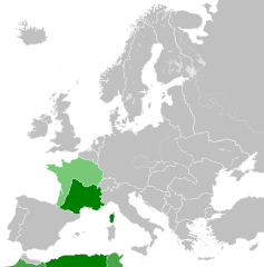
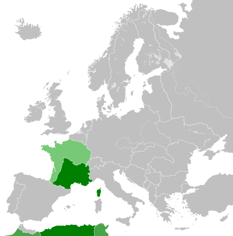
English: French State 1942 |
| Ngày | |
| Nguồn gốc | Tác phẩm được tạo bởi người tải lên |
| Tác giả | DIREKTOR |
Giấy phép
Tôi, người giữ bản quyền tác phẩm này, từ đây phát hành nó theo giấy phép sau:
Tập tin này được phát hành theo Giấy phép Creative Commons Ghi công–Chia sẻ tương tự 4.0 Quốc tế.
- Bạn được phép:
- chia sẻ – sao chép, phân phối và chuyển giao tác phẩm
- pha trộn – để chuyển thể tác phẩm
- Theo các điều kiện sau:
- ghi công – Bạn phải ghi lại tác giả và nguồn, liên kết đến giấy phép, và các thay đổi đã được thực hiện, nếu có. Bạn có thể làm các điều trên bằng bất kỳ cách hợp lý nào, miễn sao không ám chỉ rằng người cho giấy phép ủng hộ bạn hay việc sử dụng của bạn.
- chia sẻ tương tự – Nếu bạn biến tấu, biến đổi, hoặc làm tác phẩm khác dựa trên tác phẩm này, bạn chỉ được phép phân phối tác phẩm mới theo giấy phép y hệt hoặc tương thích với tác phẩm gốc.
Lịch sử tập tin
Nhấn vào ngày/giờ để xem nội dung tập tin tại thời điểm đó.
| Ngày/giờ | Hình xem trước | Kích cỡ | Thành viên | Miêu tả | |
|---|---|---|---|---|---|
| hiện tại | 10:08, ngày 28 tháng 1 năm 2015 | | 450×456 (500 kB) | DIREKTOR | Small fix. |
| 09:54, ngày 28 tháng 1 năm 2015 |  | 450×456 (500 kB) | DIREKTOR | Colour scheme | |
| 22:18, ngày 26 tháng 1 năm 2015 |  | 450×456 (500 kB) | DIREKTOR | User created page with UploadWizard |
Trang sử dụng tập tin
Có 1 trang tại Wikipedia tiếng Việt có liên kết đến tập tin (không hiển thị trang ở các dự án khác):
Sử dụng tập tin toàn cục
Những wiki sau đang sử dụng tập tin này:
- Trang sử dụng tại arz.wikipedia.org
- Trang sử dụng tại ast.wikipedia.org
- Trang sử dụng tại bg.wikipedia.org
- Trang sử dụng tại br.wikipedia.org
- Trang sử dụng tại ca.wikipedia.org
- Trang sử dụng tại ckb.wikipedia.org
- Trang sử dụng tại cs.wikipedia.org
- Trang sử dụng tại de.wikipedia.org
- Trang sử dụng tại el.wikipedia.org
- Trang sử dụng tại en.wikipedia.org
- Trang sử dụng tại es.wikipedia.org
- Trang sử dụng tại et.wikipedia.org
- Trang sử dụng tại fi.wikipedia.org
- Trang sử dụng tại fr.wikipedia.org
- Trang sử dụng tại fr.wiktionary.org
- Trang sử dụng tại ga.wikipedia.org
- Trang sử dụng tại gl.wikipedia.org
- Trang sử dụng tại he.wikipedia.org
- Trang sử dụng tại hu.wikipedia.org
- Trang sử dụng tại id.wikipedia.org
- Trang sử dụng tại it.wikipedia.org
- Trang sử dụng tại ja.wikipedia.org
- Trang sử dụng tại ka.wikipedia.org
- Trang sử dụng tại ko.wikipedia.org
- Trang sử dụng tại ky.wikipedia.org
- Trang sử dụng tại lv.wikipedia.org
- Trang sử dụng tại no.wikipedia.org
- Trang sử dụng tại nrm.wikipedia.org
- Trang sử dụng tại pcd.wikipedia.org
- Trang sử dụng tại pih.wikipedia.org
- Trang sử dụng tại pl.wikipedia.org
- Trang sử dụng tại pt.wikipedia.org
- Trang sử dụng tại ru.wikipedia.org
- Trang sử dụng tại ru.wiktionary.org
- Trang sử dụng tại sco.wikipedia.org
- Trang sử dụng tại sk.wikipedia.org
- Trang sử dụng tại sl.wikipedia.org
Xem thêm các trang toàn cục sử dụng tập tin này.