
Tập tin:IssaouaneErg Algeria ISS010-E-13539.jpg
Tập tin gốc (1.000×662 điểm ảnh, kích thước tập tin: 491 kB, kiểu MIME: image/jpeg)
Tập tin này từ Wikimedia Commons. Trang miêu tả nó ở đấy được sao chép dưới đây. Commons là kho lưu trữ tập tin phương tiện có giấy phép tự do. Bạn có thể tham gia. |
Miêu tả
| Miêu tả |
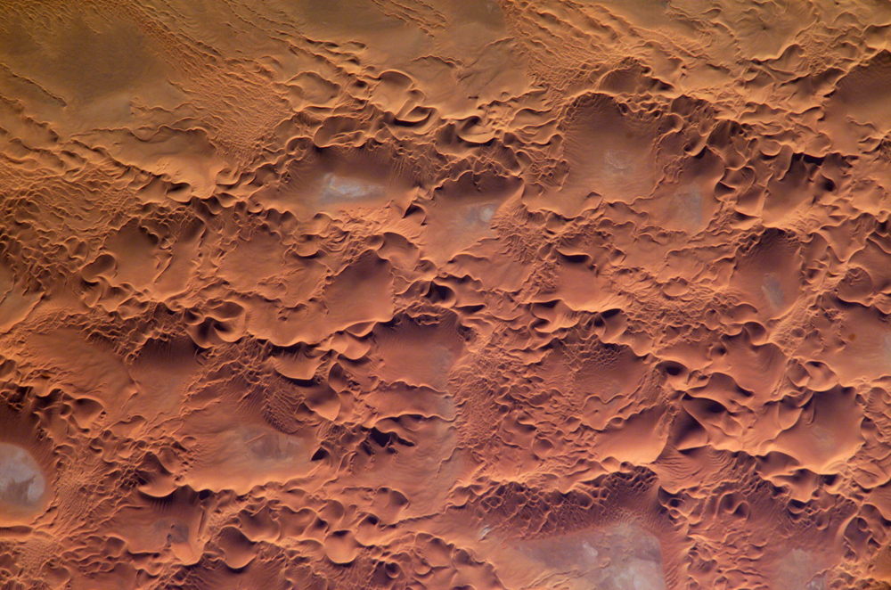
English: Astronaut photo of the Issaouane Erg (Sahara Desert), Algeria.
|
||||||||||||||||||||||||||||||||||||||||||||||||||||||
| Ngày | |||||||||||||||||||||||||||||||||||||||||||||||||||||||
| Nguồn gốc | http://earthobservatory.nasa.gov/Newsroom/NewImages/images.php3?img_id=16813 | ||||||||||||||||||||||||||||||||||||||||||||||||||||||
| Tác giả | ISS Crew Earth Observations experiment and the Image Science & Analysis Group, Johnson Space Center. | ||||||||||||||||||||||||||||||||||||||||||||||||||||||
| Giấy phép (Dùng lại tập tin) |
NASA, public domain | ||||||||||||||||||||||||||||||||||||||||||||||||||||||
Giấy phép
This file is in the public domain in the United States because it was created by the Image Science & Analysis Laboratory, of the NASA Johnson Space Center. NASA copyright policy states that "NASA material is not protected by copyright unless noted". (NASA media use guidelines or Conditions of Use of Astronaut Photographs).
Photo source: ISS010-E-13539.
|
Lịch sử tập tin
Nhấn vào ngày/giờ để xem nội dung tập tin tại thời điểm đó.
| Ngày/giờ | Hình xem trước | Kích cỡ | Thành viên | Miêu tả | |
|---|---|---|---|---|---|
| hiện tại | 17:58, ngày 18 tháng 5 năm 2006 | | 1.000×662 (491 kB) | Holly Cheng | ==Summary== {{Information | Description=Astronaut photo of the Issaouane Erg (Sahara Desert), Algeria. | Source=http://earthobservatory.nasa.gov/Newsroom/NewImages/images.php3?img_id=16813 | Date=January 16, 2005 | Author=ISS Crew Earth Observations exper |
Trang sử dụng tập tin
Sử dụng tập tin toàn cục
Những wiki sau đang sử dụng tập tin này:
- Trang sử dụng tại ar.wikipedia.org
- Trang sử dụng tại ba.wikipedia.org
- Trang sử dụng tại be.wikipedia.org
- Trang sử dụng tại bg.wikipedia.org
- Trang sử dụng tại br.wikipedia.org
- Trang sử dụng tại ceb.wikipedia.org
- Trang sử dụng tại da.wikipedia.org
- Trang sử dụng tại de.wikipedia.org
- Trang sử dụng tại en.wikipedia.org
- Trang sử dụng tại eo.wikipedia.org
- Trang sử dụng tại fi.wikipedia.org
- Trang sử dụng tại fr.wikipedia.org
- Trang sử dụng tại fr.wiktionary.org
- Trang sử dụng tại hi.wikipedia.org
- Trang sử dụng tại it.wikipedia.org
- Trang sử dụng tại it.wikibooks.org
- Trang sử dụng tại ka.wikipedia.org
- Trang sử dụng tại lt.wikipedia.org
- Trang sử dụng tại mhr.wikipedia.org
- Trang sử dụng tại mk.wikipedia.org
- Trang sử dụng tại nn.wikipedia.org
- Trang sử dụng tại pl.wikipedia.org
- Trang sử dụng tại pl.wiktionary.org
- Trang sử dụng tại ro.wikipedia.org
- Trang sử dụng tại ru.wikipedia.org
- Trang sử dụng tại sl.wikipedia.org
- Trang sử dụng tại sr.wikipedia.org
- Trang sử dụng tại sv.wikipedia.org
- Trang sử dụng tại sv.wiktionary.org
- Trang sử dụng tại uk.wikipedia.org
- Trang sử dụng tại uz.wikipedia.org
- Trang sử dụng tại www.wikidata.org