
Tập tin:Juniperus communis range map.gif
Không có độ phân giải cao hơn.
Juniperus_communis_range_map.gif (664×580 điểm ảnh, kích thước tập tin: 19 kB, kiểu MIME: image/gif)
Tập tin này từ Wikimedia Commons. Trang miêu tả nó ở đấy được sao chép dưới đây. Commons là kho lưu trữ tập tin phương tiện có giấy phép tự do. Bạn có thể tham gia. |
Miêu tả
| Miêu tả |
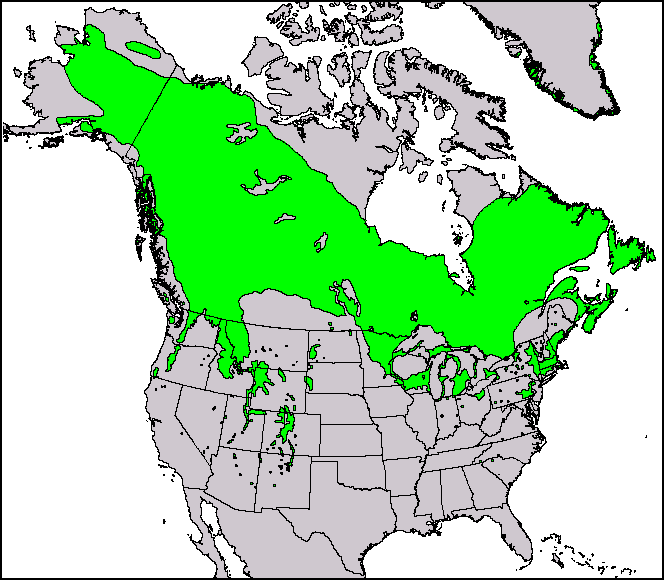
English: This North American range map of Juniperus communis, the common juniper, was published in a USGS publication: Conifers. Climate-Vegetation Atlas of North America. USGS. Retrieved on 2007-11-11. Maps and ArcView shapefiles can also be downloaded here: Little, Jr., Elbert L. Atlas. USGS. Archived from the original on 2007-07-17. Retrieved on 2007-11-11. |
|||
| Ngày | ||||
| Nguồn gốc | Thompson, Robert S.; Katherine H. Anderson and Patrick J. Bartlein (1999) Atlas of Relations Between Climatic Parameters and Distributions of Important Trees and Shrubs in North America, U.S. Geological Survey (Professional Paper 1650 A&B) | |||
| Tác giả | Robert S. Thompson, Katherine H. Anderson, and Patrick J. Bartlein | |||
| Giấy phép (Dùng lại tập tin) |
|
|||
| Phiên bản khác |
This and other maps were originally produced by Elbert L. Little, Jr. of the U.S. Department of Agriculture's Forest Service.  |
| Page | Caption |
|---|---|
| Species distribution | A species range map represents the region where individuals of a species can be found. This is the North American range map of Juniperus communis, the common juniper. |
Giấy phép
Nhật trình tải lên đầu tiên
Trang miêu tả gốc từng tồn tại ở đây. Tất cả các tên người dùng sau là tên người dùng tại en.wikipedia.
| Ngày/Giờ | Kích cỡ | Thành viên | Miêu tả |
|---|---|---|---|
| 2010-12-29 14:39:43 | 664 × 580 | Threelovemonkeys | {{Information |Description = This is a species range map of Juniperus communis, published in a USGS publication. |Source = Robert S. Thompson, Katherine H. Anderson and Patrick J. Bartlein. 1999. Atlas of Relations Between Climatic Parameters |
Lịch sử tập tin
Nhấn vào ngày/giờ để xem nội dung tập tin tại thời điểm đó.
| Ngày/giờ | Hình xem trước | Kích cỡ | Thành viên | Miêu tả | |
|---|---|---|---|---|---|
| hiện tại | 01:25, ngày 11 tháng 4 năm 2017 | | 664×580 (19 kB) | FastilyClone | Transferred from en.wikipedia (MTC!) |
Trang sử dụng tập tin
Có 1 trang tại Wikipedia tiếng Việt có liên kết đến tập tin (không hiển thị trang ở các dự án khác):
Sử dụng tập tin toàn cục
Những wiki sau đang sử dụng tập tin này:
- Trang sử dụng tại en.wikipedia.org
- Trang sử dụng tại fa.wikipedia.org
- Trang sử dụng tại uk.wikipedia.org
- Trang sử dụng tại zh.wikipedia.org