
Tập tin:KYphysiography.jpg

Kích thước hình xem trước: 800×353 điểm ảnh. Độ phân giải khác: 320×141 điểm ảnh | 824×364 điểm ảnh.
Tập tin gốc (824×364 điểm ảnh, kích thước tập tin: 159 kB, kiểu MIME: image/jpeg)
Tập tin này từ Wikimedia Commons. Trang miêu tả nó ở đấy được sao chép dưới đây. Commons là kho lưu trữ tập tin phương tiện có giấy phép tự do. Bạn có thể tham gia. |

|
Hình ảnh thuộc thể loại "map" cần được vẽ lại bằng đồ họa vector theo định dạng tập tin SVG. Để biết ưu điểm của định dạng này, hãy đọc Commons:Media for cleanup. Nếu tập tin này đã có SVG, xin hãy tải lên đây rồi thay bản mẫu này bằng {{vector version available|tên hình mới.svg}}.
|


Miêu tả
| Miêu tả |
English: I created this image using Wikipedia's map of Kentucky counties.
|
| Ngày | 1 tháng 5 năm 2007 (ngày tải lên ban đầu) |
| Nguồn gốc | Chuyển từ en.wikipedia sang Commons by byankno1. |
| Tác giả | Lamontacranston tại Wikipedia Tiếng Anh |
Giấy phép
| Tác phẩm này đã được tác giả của nó, Lamontacranston tại Wikipedia Tiếng Anh, phát hành vào phạm vi công cộng. Điều này có hiệu lực trên toàn thế giới. Tại một quốc gia mà luật pháp không cho phép điều này, thì: Lamontacranston cho phép tất cả mọi người được quyền sử dụng tác phẩm này với bất cứ mục đích nào, không kèm theo bất kỳ điều kiện nào, trừ phi luật pháp yêu cầu những điều kiện đó. |
Nhật trình tải lên đầu tiên
Trang miêu tả gốc từng tồn tại ở đây. Tất cả các tên người dùng sau là tên người dùng tại en.wikipedia.
- 2007-05-01 00:01 Lamontacranston 824×364× (162592 bytes) Bigger fonts. I created this image.
- 2007-04-30 23:54 Lamontacranston 824×364× (154693 bytes) Added text, improved edges, slightly lightened colors. I created the original.
- 2006-09-09 19:16 Lamontacranston 824×364× (55286 bytes) I created this image using Wikipedia's map of Kentucky counties.
Lịch sử tập tin
Nhấn vào ngày/giờ để xem nội dung tập tin tại thời điểm đó.
| Ngày/giờ | Hình xem trước | Kích cỡ | Thành viên | Miêu tả | |
|---|---|---|---|---|---|
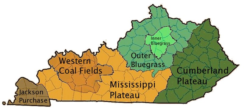
| hiện tại | 16:36, ngày 18 tháng 11 năm 2008 | | 824×364 (159 kB) | EpcotMagic | {{Information |Description={{en|I created this image using Wikipedia's map of Kentucky counties. *Dark green - Eastern Kentucky Coal fields (Cumberland Plateau) *Green - Outer Bluegrass *Light Green - Inner Bluegrass *Light Brown - Mississippi (Pennyroyal |
Trang sử dụng tập tin
Có 1 trang tại Wikipedia tiếng Việt có liên kết đến tập tin (không hiển thị trang ở các dự án khác):
Sử dụng tập tin toàn cục
Những wiki sau đang sử dụng tập tin này:
- Trang sử dụng tại ar.wikipedia.org
- Trang sử dụng tại de.wikipedia.org
- Trang sử dụng tại el.wikipedia.org
- Trang sử dụng tại en.wikipedia.org
- Trang sử dụng tại es.wikipedia.org
- Trang sử dụng tại fi.wikipedia.org
- Trang sử dụng tại he.wikipedia.org
- Trang sử dụng tại ia.wikipedia.org
- Trang sử dụng tại id.wikipedia.org
- Trang sử dụng tại it.wikipedia.org
- Trang sử dụng tại ja.wikipedia.org
- Trang sử dụng tại no.wikipedia.org
- Trang sử dụng tại pt.wikipedia.org
- Trang sử dụng tại sh.wikipedia.org
- Trang sử dụng tại simple.wikipedia.org
- Trang sử dụng tại sv.wikipedia.org
- Trang sử dụng tại zh.wikipedia.org