
Tập tin:Kivalina Alaska aerial view.jpg

Kích thước hình xem trước: 800×600 điểm ảnh. Độ phân giải khác: 320×240 điểm ảnh | 640×480 điểm ảnh | 1.024×768 điểm ảnh | 1.280×960 điểm ảnh | 1.500×1.125 điểm ảnh.
Tập tin gốc (1.500×1.125 điểm ảnh, kích thước tập tin: 208 kB, kiểu MIME: image/jpeg)
Tập tin này từ Wikimedia Commons. Trang miêu tả nó ở đấy được sao chép dưới đây. Commons là kho lưu trữ tập tin phương tiện có giấy phép tự do. Bạn có thể tham gia. |
| Miêu tả |
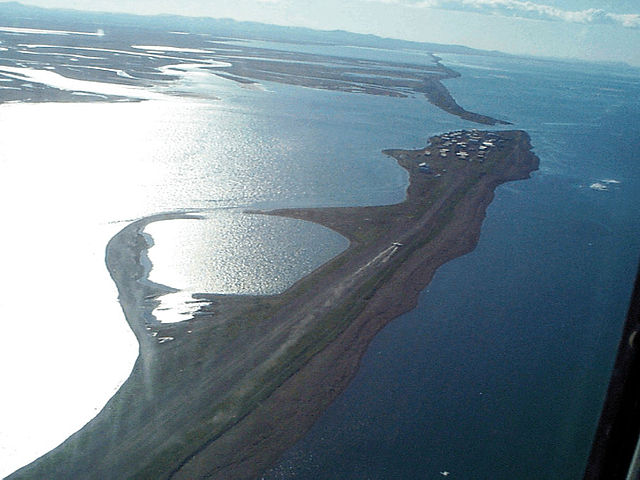
English: Aerial view of Kivalina, Alaska, USA. View is to the southeast. |
|||
| Vị trí | Kivalina, Alaska, USA 67°43′51.79″N 164°33′0.48″W / 67.7310528°N 164.5501333°W |
|||
| Ngày | ||||
| Nguồn gốc |
U.S. Army Corps of Engineers Digital Visual Library Image page Image description page Digital Visual Library home page |
|||
| Tác giả | U.S. Army Corps of Engineers, photographer not specified or unknown | |||
| Giấy phép (Dùng lại tập tin) |
|
Lịch sử tập tin
Nhấn vào ngày/giờ để xem nội dung tập tin tại thời điểm đó.
| Ngày/giờ | Hình xem trước | Kích cỡ | Thành viên | Miêu tả | |
|---|---|---|---|---|---|
| hiện tại | 03:52, ngày 21 tháng 3 năm 2007 | | 1.500×1.125 (208 kB) | DanMS | {{Information | Description = {{en|Aerial view of Kivalina, Alaska, USA. View is to the southeast.}} | Source = U.S. Army Corps of Engineers Digital Visual Library<br />[http://images.usace.army.mil/images/Hires/cepoa171.jpg Image page]<br />[h |
Trang sử dụng tập tin
Có 1 trang tại Wikipedia tiếng Việt có liên kết đến tập tin (không hiển thị trang ở các dự án khác):
Sử dụng tập tin toàn cục
Những wiki sau đang sử dụng tập tin này:
- Trang sử dụng tại azb.wikipedia.org
- Trang sử dụng tại ceb.wikipedia.org
- Trang sử dụng tại ch.wikipedia.org
- Trang sử dụng tại en.wikipedia.org
- Trang sử dụng tại fa.wikipedia.org
- Trang sử dụng tại fr.wikipedia.org
- Trang sử dụng tại ik.wikipedia.org
- Trang sử dụng tại it.wikipedia.org
- Trang sử dụng tại ja.wikipedia.org
- Trang sử dụng tại mg.wikipedia.org
- Trang sử dụng tại ml.wikipedia.org
- Trang sử dụng tại mrj.wikipedia.org
- Trang sử dụng tại nl.wikipedia.org
- Trang sử dụng tại no.wikipedia.org
- Trang sử dụng tại pt.wikipedia.org
- Trang sử dụng tại ro.wikipedia.org
- Trang sử dụng tại ru.wikipedia.org
- Trang sử dụng tại sh.wikipedia.org
- Trang sử dụng tại simple.wikipedia.org
- Trang sử dụng tại sr.wikipedia.org
- Trang sử dụng tại sw.wikipedia.org
- Trang sử dụng tại ta.wikipedia.org
- Trang sử dụng tại tg.wikipedia.org
- Trang sử dụng tại tly.wikipedia.org
- Trang sử dụng tại tr.wikipedia.org
- Trang sử dụng tại uz.wikipedia.org
- Trang sử dụng tại vo.wikipedia.org
- Trang sử dụng tại www.wikidata.org
- Trang sử dụng tại zh-min-nan.wikipedia.org