
Tập tin:Map of federal subjects of Russia (2022), disputed Crimea and Donbass.svg

Kích thước bản xem trước PNG này của tập tin SVG: 512×282 điểm ảnh. Độ phân giải khác: 320×176 điểm ảnh | 640×353 điểm ảnh | 1.024×564 điểm ảnh | 1.280×705 điểm ảnh | 2.560×1.410 điểm ảnh.
Tập tin gốc (tập tin SVG, 512×282 điểm ảnh trên danh nghĩa, kích thước: 827 kB)
Tập tin này từ Wikimedia Commons. Trang miêu tả nó ở đấy được sao chép dưới đây. Commons là kho lưu trữ tập tin phương tiện có giấy phép tự do. Bạn có thể tham gia. |
,_disputed_Crimea_and_Donbass.svg?uselang=vi)

|
The boundaries on this map show the de facto situation. This is just one of several different views on the subject (see COM:NPOV). |
Miêu tả
| Miêu tả |
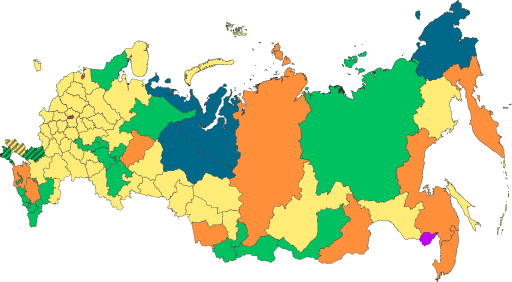
English: Copy of File:Map of federal subjects of Russia (2022).svg with disputed annexed Ukrainian territories indicated with diagonal stripes |
| Ngày | |
| Nguồn gốc |
Là ảnh phái sinh từ: Map of federal subjects of Russia 2014, disputed Crimea.svg |
| Tác giả | Mzajac, Ltbubbas |
.svg)
Giấy phép
| This map is ineligible for copyright and therefore in the public domain, because it consists entirely of information that is common property and contains no original authorship. For more information, see Commons:Threshold of originality § Maps.
|
Lịch sử tập tin
Nhấn vào ngày/giờ để xem nội dung tập tin tại thời điểm đó.
| Ngày/giờ | Hình xem trước | Kích cỡ | Thành viên | Miêu tả | |
|---|---|---|---|---|---|
| hiện tại | 19:48, ngày 4 tháng 10 năm 2022 | | 512×282 (827 kB) | Techso01 | Uploaded a work by Mzajac, Ltbubbas from {{derived from|Map of federal subjects of Russia (2014), disputed Crimea.svg}} with UploadWizard |
Trang sử dụng tập tin
Có 1 trang tại Wikipedia tiếng Việt có liên kết đến tập tin (không hiển thị trang ở các dự án khác):
Sử dụng tập tin toàn cục
Những wiki sau đang sử dụng tập tin này:
- Trang sử dụng tại ab.wikipedia.org
- Trang sử dụng tại ar.wikipedia.org
- Trang sử dụng tại ast.wikipedia.org
- Trang sử dụng tại be.wikipedia.org
- Trang sử dụng tại cs.wikipedia.org
- Trang sử dụng tại de.wikipedia.org
- Trang sử dụng tại en.wikipedia.org
- Trang sử dụng tại es.wikipedia.org
- Trang sử dụng tại fa.wikipedia.org
- Trang sử dụng tại fr.wikipedia.org
- Trang sử dụng tại is.wikipedia.org
- Trang sử dụng tại it.wikipedia.org
- Trang sử dụng tại ja.wikipedia.org
- Trang sử dụng tại ko.wikipedia.org
- Trang sử dụng tại la.wikipedia.org
- Trang sử dụng tại lez.wikipedia.org
- Trang sử dụng tại lld.wikipedia.org
- Trang sử dụng tại lt.wikipedia.org
- Trang sử dụng tại lv.wikipedia.org
- Trang sử dụng tại mi.wikipedia.org
- Trang sử dụng tại oc.wikipedia.org
- Trang sử dụng tại pt.wikipedia.org
- Trang sử dụng tại ru.wikipedia.org
- Trang sử dụng tại sl.wikipedia.org
- Trang sử dụng tại sr.wikipedia.org
- Trang sử dụng tại th.wikipedia.org
- Trang sử dụng tại tly.wikipedia.org
- Trang sử dụng tại tum.wikipedia.org
- Trang sử dụng tại uk.wikipedia.org
- Trang sử dụng tại uz.wikipedia.org
- Trang sử dụng tại vls.wikipedia.org
- Trang sử dụng tại zh.wikipedia.org
Xem thêm các trang toàn cục sử dụng tập tin này.
,_disputed_Crimea_and_Donbass.svg)
,_disputed_Crimea_and_Donbass.svg)