
Tập tin:Mount Mazama eruption timeline.PNG
Tập tin gốc (250×841 điểm ảnh, kích thước tập tin: 187 kB, kiểu MIME: image/png)
Tập tin này từ Wikimedia Commons. Trang miêu tả nó ở đấy được sao chép dưới đây. Commons là kho lưu trữ tập tin phương tiện có giấy phép tự do. Bạn có thể tham gia. |
Miêu tả
| Miêu tả |
|
| Nguồn gốc | http://pubs.usgs.gov/fs/2002/fs092-02/ (saved as PNG) |
| Tác giả | U.S. GEOLOGICAL SURVEY and the NATIONAL PARK SERVICE |
| Phiên bản khác |
    |

|
Hình ảnh thuộc thể loại "geology" cần được vẽ lại bằng đồ họa vector theo định dạng tập tin SVG. Để biết ưu điểm của định dạng này, hãy đọc Commons:Media for cleanup. Nếu tập tin này đã có SVG, xin hãy tải lên đây rồi thay bản mẫu này bằng {{vector version available|tên hình mới.svg}}.
|
Giấy phép
Hình này thuộc phạm vi công cộng tại Hoa Kỳ vì toàn bộ nội dung của nó được lấy từ Cục Khảo sát Địa chất Hoa Kỳ (USGS), một cơ quan thuộc Bộ Nội vụ Hoa Kỳ. Xem chính sách chính thức về bản quyền của USGS để biết thêm thông tin.
|
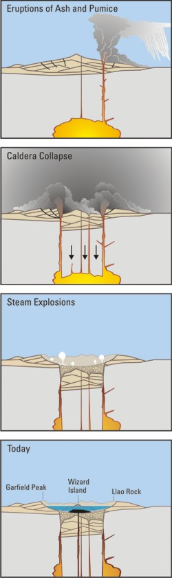
Crater Lake is an example, it is located in Oregen and was made from a valcano, making a caldera.
Lịch sử tập tin
Nhấn vào ngày/giờ để xem nội dung tập tin tại thời điểm đó.
| Ngày/giờ | Hình xem trước | Kích cỡ | Thành viên | Miêu tả | |
|---|---|---|---|---|---|
| hiện tại | 05:24, ngày 29 tháng 3 năm 2006 | 250×841 (187 kB) | Jkelly | Source: http://pubs.usgs.gov/fs/2002/fs092-02/ (saved as PNG) Author: U.S. GEOLOGICAL SURVEY and the NATIONAL PARK SERVICE Description: <blockquote>Cataclysmic eruption to present. Eruptions of ash and pumice: The cataclysmic eruption started from a ve |
Trang sử dụng tập tin
Sử dụng tập tin toàn cục
Những wiki sau đang sử dụng tập tin này:
- Trang sử dụng tại af.wikipedia.org
- Trang sử dụng tại an.wikipedia.org
- Trang sử dụng tại ar.wikipedia.org
- Trang sử dụng tại ast.wikipedia.org
- Trang sử dụng tại br.wikipedia.org
- Trang sử dụng tại ce.wikipedia.org
- Trang sử dụng tại cy.wikipedia.org
- Trang sử dụng tại de.wikipedia.org
- Trang sử dụng tại en.wikipedia.org
- Trang sử dụng tại en.wikiversity.org
- Trang sử dụng tại eo.wikipedia.org
- Trang sử dụng tại es.wikipedia.org
- Trang sử dụng tại fa.wikipedia.org
- Trang sử dụng tại fi.wikipedia.org
- Trang sử dụng tại fr.wikipedia.org
- Trang sử dụng tại id.wikipedia.org
- Trang sử dụng tại it.wikipedia.org
- Trang sử dụng tại ja.wikipedia.org
- Trang sử dụng tại ko.wikipedia.org
- Trang sử dụng tại lv.wikipedia.org
- Trang sử dụng tại min.wikipedia.org
- Trang sử dụng tại mk.wikipedia.org
- Trang sử dụng tại ml.wikipedia.org
- Trang sử dụng tại pt.wikipedia.org
- Trang sử dụng tại ru.wikipedia.org
- Trang sử dụng tại simple.wikipedia.org
- Trang sử dụng tại sk.wikipedia.org
- Trang sử dụng tại sr.wikipedia.org
- Trang sử dụng tại su.wikipedia.org
- Trang sử dụng tại www.wikidata.org