
Tập tin:NavalGuadalcanalMap.jpg

Kích thước hình xem trước: 449×599 điểm ảnh. Độ phân giải khác: 180×240 điểm ảnh | 360×480 điểm ảnh.
Tập tin gốc (800×1.067 điểm ảnh, kích thước tập tin: 104 kB, kiểu MIME: image/jpeg)
Tập tin này từ Wikimedia Commons. Trang miêu tả nó ở đấy được sao chép dưới đây. Commons là kho lưu trữ tập tin phương tiện có giấy phép tự do. Bạn có thể tham gia. |
Miêu tả
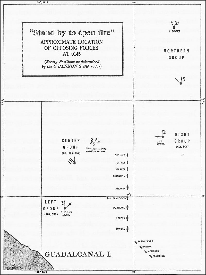
U.S. Navy map of U.S. and Japanese ship locations, just prior to opening fire during battle of November 13, 1942. U.S. ship locations are fairly accurate, except that the first U.S. ships in line began to jumble formation just before opening fire. The Japanese ship locations aren't completely accurate. From Jameson, Colin G. (1944) The Battle of Guadalcanal, 11–15 November 1942, Publications Branch, Office of Naval Intelligence, United States Navy. http://www.ibiblio.org/hyperwar/USN/USN-CN-Guadalcanal/maps/USN-CN-Guadalcanal-2.jpg
Giấy phép
Công trình này thuộc về phạm vi công cộng tại Hoa Kỳ bởi vì đây là công trình được chuẩn bị bởi một quan chức hoặc nhân viên của Chính phủ Hoa Kỳ như một phần nhiệm vụ chính thức của người đó theo các điều khoản của Title 17, Chương 1, Mục 105 của the Bộ luật Hoa Kỳ.
Chú ý: Điều này chỉ áp dụng cho các tác phẩm gốc của Chính phủ Liên bang và không áp dụng cho tác phẩm của bất kỳ tiểu bang, lãnh thổ, khối thịnh vượng chung, hạt, đô thị hoặc bất kỳ phân khu nào khác của Hoa Kỳ. Bản mẫu này cũng không áp dụng cho các thiết kế tem bưu chính được xuất bản bởi Bưu chính Hoa Kỳ kể từ năm 1978. (Xem § 313.6(C)(1) của Compendium of U.S. Copyright Office Practices). Nó cũng không áp dụng cho một số đồng xu của Hoa Kỳ; xem Điều khoản sử dụng của US Mint.
|
 | |
| Tập tin này đã được đánh dấu là không bị hạn chế dưới luật bản quyền, kể cả tất cả những quyền liên quan và lần cận. | ||
Lịch sử tập tin
Nhấn vào ngày/giờ để xem nội dung tập tin tại thời điểm đó.
| Ngày/giờ | Hình xem trước | Kích cỡ | Thành viên | Miêu tả | |
|---|---|---|---|---|---|
| hiện tại | 14:55, ngày 1 tháng 6 năm 2006 | | 800×1.067 (104 kB) | Cla68 | == Summary == Map of U.S. and Japanese ship locations, just prior to opening fire during battle of November 13, 1942. U.S. ship locations are fairly accurate, except that the first U.S. ships in line began to jumble formation just before opening fire. T |
Trang sử dụng tập tin
Có 1 trang tại Wikipedia tiếng Việt có liên kết đến tập tin (không hiển thị trang ở các dự án khác):