
Tập tin:Qaidam-basin-china.jpg

Kích thước hình xem trước: 600×600 điểm ảnh. Độ phân giải khác: 240×240 điểm ảnh | 480×480 điểm ảnh | 768×768 điểm ảnh | 1.024×1.024 điểm ảnh | 1.280×1.280 điểm ảnh.
Tập tin gốc (1.280×1.280 điểm ảnh, kích thước tập tin: 1,16 MB, kiểu MIME: image/jpeg)
Tập tin này từ Wikimedia Commons. Trang miêu tả nó ở đấy được sao chép dưới đây. Commons là kho lưu trữ tập tin phương tiện có giấy phép tự do. Bạn có thể tham gia. |
Miêu tả
| Miêu tả |
Deutsch: STS040-613-011 Qaidambecken, China, Juni 1991
English: Image Caption: STS040-613-011 Qaidam Basin, China June 1991
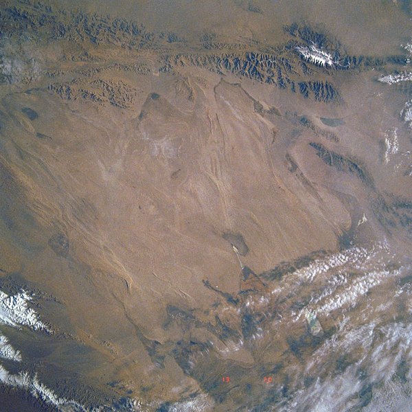
This mostly east-looking view [here rotated to place north at the top] shows the Qaidam Basin. Located in the Northern Tibetan Plateau, the Qaidam Basin sets between two branches of the Kunlun Mountains. To the north (left edge) are the Altun Mountains and to the south (right edge) are the Qimantag Mountains. The arid basin is 350 miles (560 km) long and 100 miles (160 km) wide. A salt marsh occupies most of the basin. Oil fields and refineries are located in the west part (bottom center) of the basin. Iron ore is mined in the southern part of the basin. Coal deposits have been found in the Qaidam Basin. Cooler climate crops such as wheat, highland barley, millet, and potatoes are grown during the short, cool summer months. Español: STS040-613-011 Cuenca de Qaidam, China, Junio de 1991 |
||||
| Ngày | |||||
| Nguồn gốc |
https://eol.jsc.nasa.gov/SearchPhotos/photo.pl?mission=STS040&roll=613&frame=11 (original uploader information: http://eol.jsc.nasa.gov/sseop/efs/lores.pl?PHOTO=STS040-613-11) |
||||
| Tác giả | NASA | ||||
| Photo center point |
|
Giấy phép
| This file is in the public domain in the United States because it was solely created by NASA. NASA copyright policy states that "NASA material is not protected by copyright unless noted". (See Template:PD-USGov, NASA copyright policy page or JPL Image Use Policy.) | ||
 |
Warnings:
|
Nhật trình tải lên đầu tiên
Chuyển từ en.wikipedia sang Commons by Quadell using CommonsHelper.
Trang miêu tả gốc từng tồn tại ở đây. Tất cả các tên người dùng sau là tên người dùng tại en.wikipedia.
- 2008-02-06 02:49 Mattisse 640×640× (385252 bytes) {{Information |Description=Quaidam Basin, China |Source=http://eol.jsc.nasa.gov/sseop/efs/lores.pl?PHOTO=STS040-613-11 |Date=2008-02-05 |Location=Quaidam Basin, China |Author=NASA |Permission= |other_versions= }}
| Annotations | This image is annotated: View the annotations at Commons |
Lịch sử tập tin
Nhấn vào ngày/giờ để xem nội dung tập tin tại thời điểm đó.
| Ngày/giờ | Hình xem trước | Kích cỡ | Thành viên | Miêu tả | |
|---|---|---|---|---|---|
| hiện tại | 08:18, ngày 7 tháng 8 năm 2019 | | 1.280×1.280 (1,16 MB) | LlywelynII | Reverted to version as of 08:17, 7 August 2019 (UTC) STOP ROTATING THIS |
| 08:18, ngày 7 tháng 8 năm 2019 |  | 640×640 (404 kB) | LlywelynII | Reverted to version as of 08:12, 7 August 2019 (UTC) testing | |
| 08:17, ngày 7 tháng 8 năm 2019 |  | 1.280×1.280 (1,16 MB) | LlywelynII | let's try this again... | |
| 08:12, ngày 7 tháng 8 năm 2019 |  | 640×640 (404 kB) | LlywelynII | North at top | |
| 19:34, ngày 7 tháng 9 năm 2011 |  | 640×640 (376 kB) | File Upload Bot (Magnus Manske) | {{BotMoveToCommons|en.wikipedia|year={{subst:CURRENTYEAR}}|month={{subst:CURRENTMONTHNAME}}|day={{subst:CURRENTDAY}}}} {{Information |Description={{en|Qaidam Basin, China}} |Source=Transferred from [http://en.wikipedia.org en.wikipedia]; transferred to C |
Trang sử dụng tập tin
Có 1 trang tại Wikipedia tiếng Việt có liên kết đến tập tin (không hiển thị trang ở các dự án khác):
Sử dụng tập tin toàn cục
Những wiki sau đang sử dụng tập tin này:
- Trang sử dụng tại az.wikipedia.org
- Trang sử dụng tại de.wikipedia.org
- Trang sử dụng tại en.wikipedia.org
- Trang sử dụng tại es.wikipedia.org
- Trang sử dụng tại hy.wikipedia.org
- Trang sử dụng tại id.wikipedia.org
- Trang sử dụng tại no.wikipedia.org
- Trang sử dụng tại ru.wikipedia.org
- Trang sử dụng tại sl.wikipedia.org
- Trang sử dụng tại sr.wikipedia.org
- Trang sử dụng tại sv.wikipedia.org
- Trang sử dụng tại tr.wikipedia.org
- Trang sử dụng tại zh-yue.wikipedia.org