
Tập tin:Submarine cables.png

Kích thước hình xem trước: 641×600 điểm ảnh. Độ phân giải khác: 257×240 điểm ảnh | 513×480 điểm ảnh | 1.021×955 điểm ảnh.
Tập tin gốc (1.021×955 điểm ảnh, kích thước tập tin: 81 kB, kiểu MIME: image/png)
Tập tin này từ Wikimedia Commons. Trang miêu tả nó ở đấy được sao chép dưới đây. Commons là kho lưu trữ tập tin phương tiện có giấy phép tự do. Bạn có thể tham gia. |
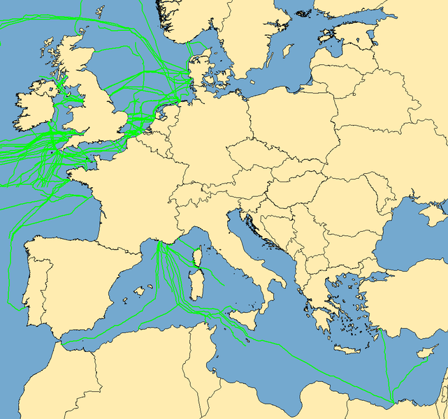
| Miêu tả | Map with examples of submarine communications cables. Some of the cables represented were incomplete in the mapping stage; they do not go to "nowhere", they are merely incomplete when this image was captured. | ||
| Ngày | (UTC) | ||
| Nguồn gốc | Data taken from public sources. Created using MapInfo Professional v8.5 and various mapping resources. | ||
| Tác giả | Rarelibra | ||
| Giấy phép (Dùng lại tập tin) |
|
Lịch sử tập tin
Nhấn vào ngày/giờ để xem nội dung tập tin tại thời điểm đó.
| Ngày/giờ | Hình xem trước | Kích cỡ | Thành viên | Miêu tả | |
|---|---|---|---|---|---|
| hiện tại | 10:53, ngày 7 tháng 10 năm 2019 | | 1.021×955 (81 kB) | Bjh21 | Reverted to version as of 19:07, 13 August 2007 (UTC): Waldyrious and User:Μυρμηγκάκι have already reverted this version, which is an objection under COM:OVERWRITE. Also the world map is already available at File:World map of submarine cables.png. |
| 03:27, ngày 7 tháng 10 năm 2019 |  | 1.601×1.025 (74 kB) | Rarelibra | Reverted to version as of 07:57, 2 October 2008 (UTC) | |
| 13:09, ngày 21 tháng 12 năm 2008 |  | 1.021×955 (81 kB) | Waldyrious | Reverted to original version. Other versions will be uploaded separately. | |
| 12:55, ngày 2 tháng 10 năm 2008 |  | 1.025×614 (16 kB) | Rarelibra | Reverted to version as of 22:13, 1 February 2008 | |
| 07:57, ngày 2 tháng 10 năm 2008 |  | 1.601×1.025 (74 kB) | Μυρμηγκάκι | Reverted to version as of 23:22, 22 August 2007 | |
| 22:13, ngày 1 tháng 2 năm 2008 |  | 1.025×614 (16 kB) | Rarelibra | Updated example of a submarine cable in the North Sea. The blue line depicts the ACTUAL location of the submarine cable, taken from GPS coordinates of the cable. The red line depicts the REPRESENTATIVE location of the submarine cable. | |
| 23:22, ngày 22 tháng 8 năm 2007 |  | 1.601×1.025 (74 kB) | Rarelibra | Updated map with cables around the world. | |
| 19:07, ngày 13 tháng 8 năm 2007 |  | 1.021×955 (81 kB) | Rarelibra | Map with examples of submarine communications cables in Europe (Mediterranean Sea, English Channel, and North Sea). Data taken from public sources for fishermen and is therefore not restricted in any sense. Created by ~~~~ for public domain use, using Map |
Trang sử dụng tập tin
Chưa có trang nào ở Wikipedia tiếng Việt liên kết đến tập tin này.
Sử dụng tập tin toàn cục
Những wiki sau đang sử dụng tập tin này:
- Trang sử dụng tại da.wikipedia.org
- Trang sử dụng tại de.wikipedia.org
- Trang sử dụng tại en.wikipedia.org