Tập tin:Diagrama enclave exclave.svg

Nội dung trang không được hỗ trợ ở ngôn ngữ khác.
Tập tin này từ Wikimedia Commons
Bách khoa toàn thư mở Wikipedia

Tập tin gốc(tập tin SVG, 1.600×1.500 điểm ảnh trên danh nghĩa, kích thước: 81 kB)

Guam(C)

Miêu tả

Miêu tả
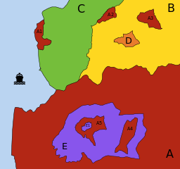
Português: Diagrama explicativo de descontinuidades territoriais: Enclaves e Exclaves.

Territórios (países, estados, municípios, etc.) diferentes são representados por cores e letras diferentes; parcelas de um mesmo território são representadas pela mesma cor e letra, sendo acrescentado um número diferente a cada uma das parcelas menores desse território (a parcela principal é identificada apenas pela letra).

  • A (vermelho):
    • tem 3 exclaves (A1, A2 e A3): é impossível ir da parcela principal de A a qualquer uma destas parcelas passando apenas por território de A; no entanto:
      • A1 não é um enclave: pode ir-se a A a A1 passando por C ou através do mar;
      • A2 não é um enclave: faz fronteira com mais do que um território "estrangeiro" (B e C);
      • A3 é um enclave: está totalmente rodeado por B;
    • tem 1 enclave (E): território "estrangeiro" totalmente rodeado por território de A;
    • tem 2 contra-enclaves, ou enclaves de segunda ordem (A4 e A5): territórios pertencentes a A encravados no interior do enclave E;
    • tem 1 contra-contra-enclave, ou enclave de terceira ordem (E1).
  • B (amarelo):
    • tem 2 enclaves (A3 e D).
  • C (verde):
    • território contínuo.
  • D (laranja):
    • é um território-enclave: é territorialmente contínuo, mas o seu território está totalmente rodeado por um único território "estrangeiro" (B).
  • E (lilás):
    • é um território-enclave: está encravado em A;
    • tem 2 enclaves (A4 e A5), que são contra-enclaves do território que circunda E;
    • tem 1 contra-enclave (E1), que é um contra-contra-enclave de A.


Em termos de Topologia Matemática, A e E são considerados superfícies desconexas e B, C e D são considerados superfícies conexas. No entanto, C e D são ainda considerados superfícies simplesmente conexas, enquanto B não o é (tem género 2, o número de "buracos" existentes em B).
English: Explicative diagram of territorial discontinuities: Enclaves and Exclaves.

Different territories (countries, states, counties, municipalities, etc.) are represented by different colours and letters; separated parts of the same territory are represented by the same colour and letter, with a different number added to each smaller part of that territory (the main part is identified by the letter only).

  • A (red):
    • has 3 exclaves (A1, A2 and A3): it is impossible to go from the main part A to any of these pasts going only through territory of A; however:
      • A1 is not an enclave: you can go from A to A1 passing through C or through the sea;
      • A2 is not an enclave: it has land frontiers with more than one "foreign" territory (B and C);
      • A3 is an enclave: it is totally surrounded by B;
    • has 1 enclave (E): "foreign" territory totally surrounded by territory of A;
    • has 2 counter-enclaves, or second-order enclaves (A4 and A5): territories belonging to A which are encroached inside the enclave E;
    • has 1 counter-counter-enclave, or third-order enclave de (E1).
  • B (yellow):
    • has 2 enclaves (A3 and D).
  • C (green):
    • continuous territory.
  • D (orange):
    • is an enclaved territory: it is territorially continuous, but its territory is totally surrounded by a single "foreign" territory (B).
  • E (purple):
    • is an enclaved territory: it is encroached inside A;
    • has 2 enclaves (A4 and A5) which are counter-enclaves of the territory surrounding E;
    • has 1 counter-enclave (E1) which is a counter-counter-enclave of A.
In topological terms, A and E are considered non-connected surfaces, and B, C and D are considered connected surfaces. However, C and D are also considered simply connected surfaces, while B is not (it has genus 2, the number of "holes" in B).
Ngày
Nguồn gốc Tác phẩm được tạo bởi người tải lên + File:TransmetropoleNavette.svg (icon)
Tác giả Gazilion

Giấy phép

Tôi, người giữ bản quyền tác phẩm này, từ đây phát hành nó theo giấy phép sau:
Creative Commons CC-Zero Tập tin này được phân phối theo Creative Commons Hiến tặng vào Phạm vi Công cộng Toàn thế giới CC0.
Người nào gán tài liệu này với tác phẩm nghĩa là đã hiến tác phẩm cho phạm vi công cộng bằng cách từ bỏ mọi quyền lợi của người đó đối với tác phẩm theo quy định của luật bản quyền, có hiệu lực trên toàn thế giới và các quyền lợi pháp lý phụ mà người đó có được trong tác phẩm, đến mức độ mà luật pháp cho phép. Bạn được tự do sao chép, phân phối, và biểu diễn tác phẩm này, tất cả đều không bắt buộc ghi công.

Chú thích

Ghi một dòng giải thích những gì có trong tập tin này
Explicative diagram of territorial discontinuities: Enclaves and Exclaves

Khoản mục được tả trong tập tin này

mô tả

Lịch sử tập tin

Nhấn vào ngày/giờ để xem nội dung tập tin tại thời điểm đó.

Ngày/giờHình xem trướcKích cỡThành viênMiêu tả
hiện tại01:50, ngày 18 tháng 4 năm 2014Hình xem trước của phiên bản lúc 01:50, ngày 18 tháng 4 năm 20141.600×1.500 (81 kB)GazilionEtiqueta do mar substituída por ícone, para permitir o uso multilingue.
01:04, ngày 17 tháng 4 năm 2014Hình xem trước của phiên bản lúc 01:04, ngày 17 tháng 4 năm 20141.600×1.500 (78 kB)GazilionUser created page with UploadWizard

Chưa có trang nào ở Wikipedia tiếng Việt liên kết đến tập tin này.

Sử dụng tập tin toàn cục

Những wiki sau đang sử dụng tập tin này:

Đặc tính hình