
Tập tin:EXTERIOR VIEW, FRONT ELEVATION - Corry Homestead, Corry House, State Route 69, 10 miles South of Jasper (244 School Street), Oakman, Walker County, AL HABS ALA,64-OAK,A-1.tif

Kích thước bản xem trước JPG này của tập tin TIF: 800×584 điểm ảnh. Độ phân giải khác: 320×234 điểm ảnh | 640×468 điểm ảnh | 1.024×748 điểm ảnh | 1.280×935 điểm ảnh | 2.560×1.870 điểm ảnh | 5.000×3.653 điểm ảnh.
Tập tin gốc (5.000×3.653 điểm ảnh, kích thước tập tin: 17,42 MB, kiểu MIME: image/tiff)
Tập tin này từ Wikimedia Commons. Trang miêu tả nó ở đấy được sao chép dưới đây. Commons là kho lưu trữ tập tin phương tiện có giấy phép tự do. Bạn có thể tham gia. |
Miêu tả
| EXTERIOR VIEW, FRONT ELEVATION - Corry Homestead, Corry House, State Route 69, 10 miles South of Jasper (244 School Street), Oakman, Walker County, AL | ||||
|---|---|---|---|---|
| Nhiếp ảnh gia |
Related names:
|
|||
| Tựa đề |
EXTERIOR VIEW, FRONT ELEVATION - Corry Homestead, Corry House, State Route 69, 10 miles South of Jasper (244 School Street), Oakman, Walker County, AL |
|||
| Depicted place | Alabama; Walker County; Oakman | |||
| Ngày | Documentation compiled after 1933 | |||
| Kích thước | 8 x 10 in. | |||
| Nơi đang treo |
Library of Congress Prints and Photographs Division Washington, D.C. 20540 USA http://hdl.loc.gov/loc.pnp/pp.print |
|||
| Số lưu trữ |
HABS ALA,64-OAK,A-1 |
|||
| Gốc gác tác phẩm |
|
|||
| Ghi chú |
|
|||
| Nguồn gốc | https://www.loc.gov/pictures/item/al1160.photos.046569p | |||
| Giấy phép (Dùng lại tập tin) |
|
|||

| Vị trí đối tượng | | Xem hình này và các hình ảnh lân cận trên: OpenStreetMap |
|---|
Lịch sử tập tin
Nhấn vào ngày/giờ để xem nội dung tập tin tại thời điểm đó.
| Ngày/giờ | Hình xem trước | Kích cỡ | Thành viên | Miêu tả | |
|---|---|---|---|---|---|
| hiện tại | 03:08, ngày 1 tháng 7 năm 2014 | 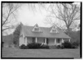 | 5.000×3.653 (17,42 MB) | Fæ | GWToolset: Creating mediafile for Fæ. HABS batch upload 29 June 2014 (101:150) |
Trang sử dụng tập tin
Có 1 trang tại Wikipedia tiếng Việt có liên kết đến tập tin (không hiển thị trang ở các dự án khác):
Sử dụng tập tin toàn cục
Những wiki sau đang sử dụng tập tin này:
- Trang sử dụng tại ar.wikipedia.org
- Trang sử dụng tại arz.wikipedia.org
- Trang sử dụng tại ca.wikipedia.org
- Trang sử dụng tại ceb.wikipedia.org
- Trang sử dụng tại ce.wikipedia.org
- Trang sử dụng tại cy.wikipedia.org
- Trang sử dụng tại es.wikipedia.org
- Trang sử dụng tại eu.wikipedia.org
- Trang sử dụng tại fr.wikipedia.org
- Trang sử dụng tại ht.wikipedia.org
- Trang sử dụng tại it.wikipedia.org
- Trang sử dụng tại lld.wikipedia.org
- Trang sử dụng tại no.wikipedia.org
- Trang sử dụng tại pl.wikipedia.org
- Trang sử dụng tại pt.wikipedia.org
- Trang sử dụng tại sr.wikipedia.org
- Trang sử dụng tại tt.wikipedia.org
- Trang sử dụng tại uk.wikipedia.org
- Trang sử dụng tại uz.wikipedia.org
- Trang sử dụng tại www.wikidata.org
- Trang sử dụng tại zh-min-nan.wikipedia.org