
Tập tin:Heavy Rains in Southern Japan.gif
Không có độ phân giải cao hơn.
Heavy_Rains_in_Southern_Japan.gif (320×240 điểm ảnh, kích thước tập tin: 8,35 MB, kiểu MIME: image/gif, có lặp, 268 khung ảnh, 8,0 s)
Tập tin này từ Wikimedia Commons. Trang miêu tả nó ở đấy được sao chép dưới đây. Commons là kho lưu trữ tập tin phương tiện có giấy phép tự do. Bạn có thể tham gia. |
Miêu tả
| Miêu tả |
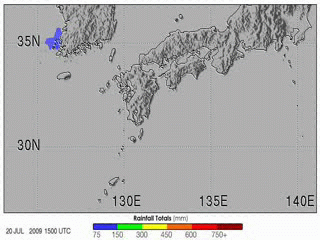
English: The 2009 summer monsoon brought torrential rains to south western Japan in July. This animation shows rainfall estimates for southern Japan and the surrounding region from July 20–27. The most prominent feature is a large bull’s-eye of heavy rain centred over the northern part of Kyushu and the south western tip of Honshu. Rainfall totals exceeded 600 millimetres (shown in deep blue) at the centre of this rain area, with lesser amounts of up to 150 millimetres (shown in pale green) extending into central Japan. The heavy rains led to widespread flash flooding and numerous landslides. As of late July 2009, eight people were reported to have died as a result, with nine more still missing, according to news reports. Each year as the Earth’s orbit brings the Northern Hemisphere back under more direct sunlight, the Asian continent starts to heat up. Land surfaces have less heat capacity than surrounding oceans, and they heat up faster. This land-sea temperature difference causes the winds to shift; warm air rises over the continent, and moist air from over the oceans flows in to replace it. In East Asia, the boundary between the warm, humid air from the ocean to the south and the continental air to the north often becomes more or less stationary. This stationary front is known as the Baiu front in Japan and as the Mei-yu front in China. The location of the front migrates slowly northward over eastern China, Korea, Taiwan, and Japan over the course of spring and early summer, providing a focus for showers and rain, especially when waves of low pressure move along the front. Mei-yu means “plum rains” in Chinese, so called because the widespread rains often occur at the time when plums ripen, which is typically May and June. Baiu season in Japan typically runs from June through July. |
| Ngày | |
| Nguồn gốc | NASA Earth Observatory |
| Tác giả | Hal Pierce |
Animation created using near-real-time data provided courtesy of TRMM Science Data and Information System at Goddard Space Flight Centre. Instrument: TRMM - MPA
Giấy phép
| This file is in the public domain in the United States because it was solely created by NASA. NASA copyright policy states that "NASA material is not protected by copyright unless noted". (See Template:PD-USGov, NASA copyright policy page or JPL Image Use Policy.) | ||
 |
Warnings:
|
Lịch sử tập tin
Nhấn vào ngày/giờ để xem nội dung tập tin tại thời điểm đó.
| Ngày/giờ | Hình xem trước | Kích cỡ | Thành viên | Miêu tả | |
|---|---|---|---|---|---|
| hiện tại | 21:56, ngày 31 tháng 7 năm 2009 | | 320×240 (8,35 MB) | Originalwana | {{Information |Description={{en|1=The 2009 summer monsoon brought torrential rains to south western Japan in July. This animatin shows rainfall estimates for southern Japan and the surrounding region from July 20–27. The most prominent feature is a larg |
Trang sử dụng tập tin
Có 2 trang tại Wikipedia tiếng Việt có liên kết đến tập tin (không hiển thị trang ở các dự án khác):
Sử dụng tập tin toàn cục
Những wiki sau đang sử dụng tập tin này:
- Trang sử dụng tại cs.wikipedia.org
- Trang sử dụng tại en.wikipedia.org
- Trang sử dụng tại fi.wikipedia.org
- Trang sử dụng tại id.wikipedia.org
- Trang sử dụng tại ja.wikipedia.org
- Trang sử dụng tại ms.wikipedia.org
- Trang sử dụng tại si.wikipedia.org
- Trang sử dụng tại te.wikipedia.org
- Trang sử dụng tại uk.wikipedia.org
- Trang sử dụng tại www.wikidata.org
- Trang sử dụng tại zh.wikipedia.org