
Tập tin:Iron age strap union (FindID 53821).jpg

Kích thước hình xem trước: 495×599 điểm ảnh. Độ phân giải khác: 198×240 điểm ảnh | 397×480 điểm ảnh | 838×1.014 điểm ảnh.
Tập tin gốc (838×1.014 điểm ảnh, kích thước tập tin: 185 kB, kiểu MIME: image/jpeg)
Tập tin này từ Wikimedia Commons. Trang miêu tả nó ở đấy được sao chép dưới đây. Commons là kho lưu trữ tập tin phương tiện có giấy phép tự do. Bạn có thể tham gia. |
Miêu tả
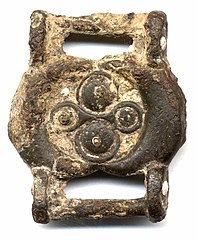
| Iron age strap union | |||
|---|---|---|---|
| Nhiếp ảnh gia |
Suffolk County Council, Ciorstaidh Hayward Trevarthen, 2003-11-05 10:35:02 |
||
| Tựa đề |
Iron age strap union |
||
| Miêu tả |
English: Copper alloy double-sided strap union. The oval central plate element has a frame of two raised crescents forming a central circular recess. On one side in the recess are two large raised ring and dot/ roundel decorations flanking two smaller ring and dots with a continuous frame forming an hourglass shape. At the centre of each of the roundels on the first side is a slight projection. This design is mirrored on the other side, although it is obscured by heavy corrosion. Instead of the domed roundels, on the second side these elements are flatter and each have a central spike that would have held a disc of coral (now missing). At either side of the oval central plate longitudinally is a circular sectioned attachment bar. These are attached on round-ended lugs projecting from the sides of the plate. These lugs are decorated with a white dot on the outer face. This is may be enamel. The strap union is quite thickly cast with a figure of eight profile. |
||
| Depicted place | (County of findspot) Dorset | ||
| Ngày | IRON AGE | ||
| Số lưu trữ |
FindID: 53821 Old ref: SOMDOR-CF0B77 Filename: STRAPUNIONf.JPG |
||
| Gốc gác tác phẩm |
|
||
| Nguồn gốc |
https://finds.org.uk/database/ajax/download/id/12020 Catalog: https://finds.org.uk/database/images/image/id/12020/recordtype/artefacts archive copy at the Wayback Machine Artefact: https://finds.org.uk/database/artefacts/record/id/53821 |
||
| Giấy phép (Dùng lại tập tin) |
Attribution-ShareAlike License version 4.0 (verified 23 tháng 11 năm 2020) | ||
| Phiên bản khác |
|
||
.jpg)
.jpg?uselang=vi)
| Vị trí đối tượng | | Xem hình này và các hình ảnh lân cận trên: OpenStreetMap |
|---|
.jpg¶ms=050.723200_N_-002.644660_E_globe:Earth_class:object_type:object__&language=vi)
Giấy phép
Tập tin này được phát hành theo Giấy phép Creative Commons Ghi công–Chia sẻ tương tự 4.0 Quốc tế.
Ghi công: The Portable Antiquities Scheme/ The Trustees of the British Museum
- Bạn được phép:
- chia sẻ – sao chép, phân phối và chuyển giao tác phẩm
- pha trộn – để chuyển thể tác phẩm
- Theo các điều kiện sau:
- ghi công – Bạn phải ghi lại tác giả và nguồn, liên kết đến giấy phép, và các thay đổi đã được thực hiện, nếu có. Bạn có thể làm các điều trên bằng bất kỳ cách hợp lý nào, miễn sao không ám chỉ rằng người cho giấy phép ủng hộ bạn hay việc sử dụng của bạn.
- chia sẻ tương tự – Nếu bạn biến tấu, biến đổi, hoặc làm tác phẩm khác dựa trên tác phẩm này, bạn chỉ được phép phân phối tác phẩm mới theo giấy phép y hệt hoặc tương thích với tác phẩm gốc.
Lịch sử tập tin
Nhấn vào ngày/giờ để xem nội dung tập tin tại thời điểm đó.
| Ngày/giờ | Hình xem trước | Kích cỡ | Thành viên | Miêu tả | |
|---|---|---|---|---|---|
| hiện tại | 16:24, ngày 30 tháng 1 năm 2017 | | 838×1.014 (185 kB) | Fæ | Portable Antiquities Scheme, DOR, FindID: 53821, iron age, page 602, batch count 10500 |
Trang sử dụng tập tin
Có 1 trang tại Wikipedia tiếng Việt có liên kết đến tập tin (không hiển thị trang ở các dự án khác):
Sử dụng tập tin toàn cục
Những wiki sau đang sử dụng tập tin này:
- Trang sử dụng tại ca.wikipedia.org
- Trang sử dụng tại en.wikipedia.org
- Trang sử dụng tại es.wikipedia.org
- Trang sử dụng tại www.wikidata.org
.jpg)