
Tập tin:Korean war 1950-1953.gif
Kích thước hình xem trước: 387×600 điểm ảnh. Độ phân giải khác: 155×240 điểm ảnh | 562×871 điểm ảnh.
Tập tin gốc (562×871 điểm ảnh, kích thước tập tin: 1,32 MB, kiểu MIME: image/gif, có lặp, 20 khung ảnh, 30 s)
Tập tin này từ Wikimedia Commons. Trang miêu tả nó ở đấy được sao chép dưới đây. Commons là kho lưu trữ tập tin phương tiện có giấy phép tự do. Bạn có thể tham gia. |

Miêu tả
| Miêu tả |
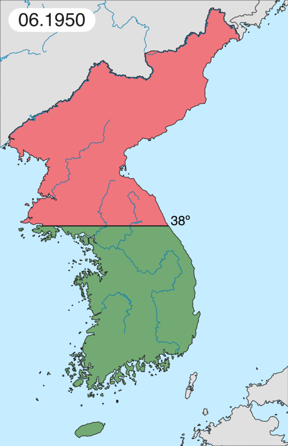
English: Map of Korean war from May 1950 to July 1951, showing:
Français : Carte de la guerre de Corée de mai 1950 à juillet 1951, montrant:
Deutsch: Karte des Koreakriegs von Mai 1950 bis Juli 1951, abgebildet:
Italiano: Mappa della guerra di Corea dal maggio 1950 al luglio 1951, rappresentante:
|
| Ngày | |
| Nguồn gốc | Tác phẩm được tạo bởi người tải lên |
| Tác giả | Leomonaci98 |
Giấy phép
Tôi, người giữ bản quyền tác phẩm này, từ đây phát hành nó theo các giấy phép sau:

|
Bạn có quyền sao chép, phân phối và/hoặc sửa đổi tài liệu này theo những điều khoản được quy định trong Giấy phép Tài liệu Tự do GNU, phiên bản 1.2 hoặc các phiên bản mới hơn được Quỹ Phần mềm Tự do; quy định; ngoại trừ những phần không được sửa đổi, bìa trước và bìa sau. Bạn có thể xem giấy phép nói trên ở phần Giấy phép Tài liệu Tự do GNU. |
| Tập tin này được phát hành theo Giấy phép Creative Commons Ghi công - Chia sẻ tương tự 3.0 Chưa chuyển đồi | ||
| ||
| Thẻ quyền này được thêm vào tập tin trong khi cập nhật giấy phép GFDL. |
Bạn có thể chọn giấy phép mà bạn muốn.
Lịch sử tập tin
Nhấn vào ngày/giờ để xem nội dung tập tin tại thời điểm đó.
| Ngày/giờ | Hình xem trước | Kích cỡ | Thành viên | Miêu tả | |
|---|---|---|---|---|---|
| hiện tại | 20:20, ngày 16 tháng 2 năm 2020 | | 562×871 (1,32 MB) | Leomonaci98 | Graphic update |
| 01:02, ngày 1 tháng 5 năm 2013 |  | 227×400 (85 kB) | Spesh531 | update for every month | |
| 08:47, ngày 9 tháng 6 năm 2006 |  | 227×400 (37 kB) | Roke~commonswiki | rm white | |
| 06:25, ngày 8 tháng 6 năm 2006 |  | 227×400 (37 kB) | Roke~commonswiki | add OngJin peninsula after comment, also blank frame at end | |
| 15:14, ngày 5 tháng 6 năm 2006 |  | 227×400 (37 kB) | Roke~commonswiki | Korean war, showing North Korean, Chinese and communist forces (red); South Korean, US and United Nations forces (green). Category: Korean War Category: Animated maps |
Trang sử dụng tập tin
Có 4 trang tại Wikipedia tiếng Việt có liên kết đến tập tin (không hiển thị trang ở các dự án khác):
Sử dụng tập tin toàn cục
Những wiki sau đang sử dụng tập tin này:
- Trang sử dụng tại af.wikipedia.org
- Trang sử dụng tại az.wikipedia.org
- Trang sử dụng tại bat-smg.wikipedia.org
- Trang sử dụng tại bg.wikipedia.org
- Trang sử dụng tại br.wikipedia.org
- Trang sử dụng tại bs.wikipedia.org
- Trang sử dụng tại ca.wikipedia.org
- Corea del Nord
- Corea del Sud
- Ióssif Stalin
- Mao Zedong
- Winston Churchill
- Harry Truman
- Guerra de Corea
- Kim Il-sung
- Viatxeslav Mólotov
- Gueorgui Malenkov
- Douglas MacArthur
- Lavrenti Béria
- M*A*S*H (pel·lícula)
- Clement Attlee
- Mark Wayne Clark
- Zona desmilitaritzada de Corea
- República Popular d'Hongria
- Syngman Rhee
- Peng Dehuai
- Força Aèria de l'Exèrcit Popular de Corea
- Forces Armades de Corea del Nord
- Forces Armades de la República de Corea
- 65è Regiment d'Infanteria (Estats Units)
- Frontera entre Corea del Nord i Corea del Sud
- Kim Chaek
- Batalla d'Inchon
- Plantilla:Guerra de Corea
- Pak Hon-yong
- Trang sử dụng tại ckb.wikipedia.org
- Trang sử dụng tại cs.wikipedia.org
- Trang sử dụng tại cy.wikipedia.org
- Trang sử dụng tại da.wikipedia.org
- Trang sử dụng tại de.wikipedia.org
- Trang sử dụng tại el.wikipedia.org
- Trang sử dụng tại en.wikipedia.org
Xem thêm các trang toàn cục sử dụng tập tin này.