
Tập tin:Kuk New Guinea 2002.jpg

Kích thước hình xem trước: 758×600 điểm ảnh. Độ phân giải khác: 303×240 điểm ảnh | 607×480 điểm ảnh | 971×768 điểm ảnh | 1.280×1.013 điểm ảnh | 2.560×2.026 điểm ảnh | 2.664×2.108 điểm ảnh.
Tập tin gốc (2.664×2.108 điểm ảnh, kích thước tập tin: 1,27 MB, kiểu MIME: image/jpeg)
Tập tin này từ Wikimedia Commons. Trang miêu tả nó ở đấy được sao chép dưới đây. Commons là kho lưu trữ tập tin phương tiện có giấy phép tự do. Bạn có thể tham gia. |
Miêu tả
| Miêu tả |
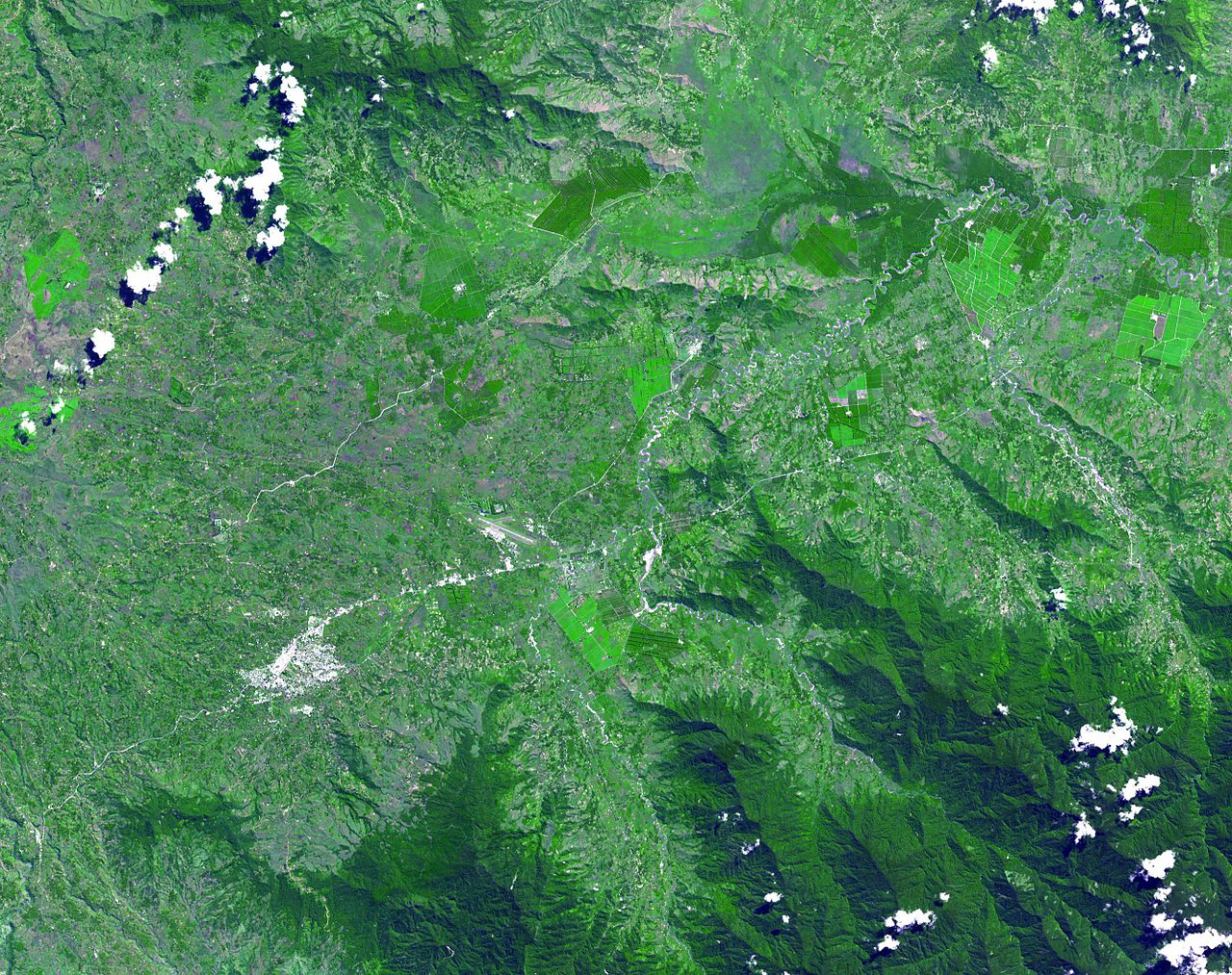
English: The Kuk Early Agricultural Site consists of 116 ha of swamps in the western highlands of New Guinea 1,500 meters above sea-level. Archaeological excavation has revealed the landscape to be one of wetland reclamation worked almost continuously for 7,000, and possibly for 10,000 years. The area was declared a UNESCO World Heritage Site in 2008. The image was acquired May 7, 2002, covers an area of 31.6 x 40 km, and is located at 5.8° S, 144.3° E. |
| Ngày | |
| Nguồn gốc | http://photojournal.jpl.nasa.gov/catalog/PIA13090 |
| Tác giả | NASA: JPL |
Giấy phép
| This file is in the public domain in the United States because it was solely created by NASA. NASA copyright policy states that "NASA material is not protected by copyright unless noted". (See Template:PD-USGov, NASA copyright policy page or JPL Image Use Policy.) | ||
 |
Warnings:
|
Lịch sử tập tin
Nhấn vào ngày/giờ để xem nội dung tập tin tại thời điểm đó.
| Ngày/giờ | Hình xem trước | Kích cỡ | Thành viên | Miêu tả | |
|---|---|---|---|---|---|
| hiện tại | 02:54, ngày 20 tháng 5 năm 2010 | | 2.664×2.108 (1,27 MB) | Elekhh | {{Information |Description={{en|1=The Kuk Early Agricultural Site consists of 116 ha of swamps in the western highlands of New Guinea 1,500 meters above sea-level. Archaeological excavation has revealed the landsca |
Trang sử dụng tập tin
Có 2 trang tại Wikipedia tiếng Việt có liên kết đến tập tin (không hiển thị trang ở các dự án khác):
Sử dụng tập tin toàn cục
Những wiki sau đang sử dụng tập tin này:
- Trang sử dụng tại af.wikipedia.org
- Trang sử dụng tại ar.wikipedia.org
- Trang sử dụng tại ast.wikipedia.org
- Trang sử dụng tại be.wikipedia.org
- Trang sử dụng tại ca.wikipedia.org
- Trang sử dụng tại cs.wikipedia.org
- Trang sử dụng tại de.wikipedia.org
- Trang sử dụng tại de.wikivoyage.org
- Trang sử dụng tại en.wikipedia.org
- Trang sử dụng tại es.wikipedia.org
- Trang sử dụng tại fa.wikipedia.org
- Trang sử dụng tại fr.wikipedia.org
- Trang sử dụng tại fr.wikivoyage.org
- Trang sử dụng tại gl.wikipedia.org
- Trang sử dụng tại he.wikipedia.org
- Trang sử dụng tại he.wikivoyage.org
- Trang sử dụng tại hr.wikipedia.org
- Trang sử dụng tại hy.wikipedia.org
- Trang sử dụng tại id.wikipedia.org
- Trang sử dụng tại it.wikipedia.org
- Trang sử dụng tại it.wikivoyage.org
- Trang sử dụng tại ja.wikipedia.org
- Trang sử dụng tại ka.wikipedia.org
- Trang sử dụng tại kk.wikipedia.org
- Trang sử dụng tại la.wikipedia.org
- Trang sử dụng tại lt.wikipedia.org
- Trang sử dụng tại lv.wikipedia.org
Xem thêm các trang toàn cục sử dụng tập tin này.