
Tập tin:Land surface temperature anomaly over East Asia in January 2016.jpg
Không có độ phân giải cao hơn.
Land_surface_temperature_anomaly_over_East_Asia_in_January_2016.jpg (720×536 điểm ảnh, kích thước tập tin: 236 kB, kiểu MIME: image/jpeg)
Tập tin này từ Wikimedia Commons. Trang miêu tả nó ở đấy được sao chép dưới đây. Commons là kho lưu trữ tập tin phương tiện có giấy phép tự do. Bạn có thể tham gia. |
Miêu tả
| Miêu tả |
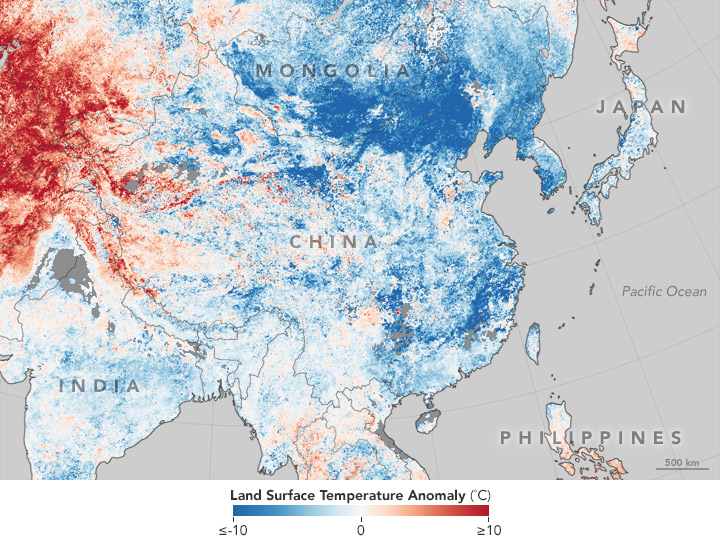
English: This temperature anomaly map is based on data from the Moderate Resolution Imaging Spectroradiometer (MODIS) on NASA’s Terra satellite. It shows land surface temperatures (LSTs) from January 17–24, 2016, compared to the 2001–2010 average for the same eight-day period. |
| Ngày | |
| Nguồn gốc | http://earthobservatory.nasa.gov/IOTD/view.php?id=87420 |
| Tác giả | NASA |
Giấy phép
| This file is in the public domain in the United States because it was solely created by NASA. NASA copyright policy states that "NASA material is not protected by copyright unless noted". (See Template:PD-USGov, NASA copyright policy page or JPL Image Use Policy.) | ||
 |
Warnings:
|
Lịch sử tập tin
Nhấn vào ngày/giờ để xem nội dung tập tin tại thời điểm đó.
| Ngày/giờ | Hình xem trước | Kích cỡ | Thành viên | Miêu tả | |
|---|---|---|---|---|---|
| hiện tại | 00:40, ngày 31 tháng 1 năm 2016 | | 720×536 (236 kB) | Jolly Janner | User created page with UploadWizard |
Trang sử dụng tập tin
Có 1 trang tại Wikipedia tiếng Việt có liên kết đến tập tin (không hiển thị trang ở các dự án khác):
Sử dụng tập tin toàn cục
Những wiki sau đang sử dụng tập tin này:
- Trang sử dụng tại en.wikipedia.org
- Trang sử dụng tại fa.wikipedia.org
- Trang sử dụng tại fi.wikipedia.org
- Trang sử dụng tại hak.wikipedia.org
- Trang sử dụng tại ja.wikipedia.org
- Trang sử dụng tại zh-min-nan.wikipedia.org
- Trang sử dụng tại zh-yue.wikipedia.org
- Trang sử dụng tại zh.wikipedia.org