
Tập tin:Manama bahrain.jpg

Kích thước hình xem trước: 591×600 điểm ảnh. Độ phân giải khác: 236×240 điểm ảnh | 473×480 điểm ảnh | 757×768 điểm ảnh | 1.009×1.024 điểm ảnh | 2.017×2.048 điểm ảnh | 3.968×4.028 điểm ảnh.
Tập tin gốc (3.968×4.028 điểm ảnh, kích thước tập tin: 9,65 MB, kiểu MIME: image/jpeg)
Tập tin này từ Wikimedia Commons. Trang miêu tả nó ở đấy được sao chép dưới đây. Commons là kho lưu trữ tập tin phương tiện có giấy phép tự do. Bạn có thể tham gia. |
Miêu tả
| Miêu tả |
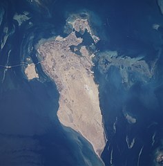
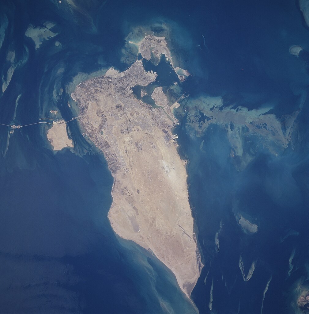
Español: Vista lateral de Bahréin desde el espacio
English: The capital city of Al Manamah, situated on the northeast tip of the island country of Bahrain, can be seen in this west-looking view. With a population of over 155000, Al Manamah is an international banking center with oil refineries, light industry, and is a duty free port. Tourism has also become a major industry. The main island of Bahrain is 30 miles (48 km) long north to south, and 10 miles (16 km) wide east to west. The island name comes from the Arabic word meaning "two seas". Bahrain is located 15 miles (24 km) off the eastern coast of Saudi Arabia in the Persian Gulf. The island is a low-lying barren desert with outcroppings of limestone that form low rolling hills, cliffs, and shallow ravines. The low rolling hills are called the Jabal Ad Dukhan (Mountains of Smoke) named for the mist that often wreathes the 543 foot-135 meters summit. Extending from the main island of Bahrain westward and exiting the view near the top center of the image is the causeway that connects Saudi Arabia to Bahrain. |
| Ngày | Taken on 25 tháng 6 năm 1996 lúc 10:31:09 |
| Nguồn gốc | https://eol.jsc.nasa.gov/SearchPhotos/photo.pl?mission=STS078&roll=748&frame=12 |
| Tác giả | NASA/STS-78 |
| Vị trí đối tượng | | Xem hình này và các hình ảnh lân cận trên: OpenStreetMap |
|---|
This image or video was catalogued by Johnson Space Center of the United States National Aeronautics and Space Administration (NASA) under Photo ID: STS078-748-12. This tag does not indicate the copyright status of the attached work. A normal copyright tag is still required. See Commons:Licensing. Other languages:
|
Miêu tả
This file is in the public domain in the United States because it was created by the Image Science & Analysis Laboratory, of the NASA Johnson Space Center. NASA copyright policy states that "NASA material is not protected by copyright unless noted". (NASA media use guidelines or Conditions of Use of Astronaut Photographs).
Photo source: STS078-748-12.
|
Lịch sử tập tin
Nhấn vào ngày/giờ để xem nội dung tập tin tại thời điểm đó.
| Ngày/giờ | Hình xem trước | Kích cỡ | Thành viên | Miêu tả | |
|---|---|---|---|---|---|
| hiện tại | 02:13, ngày 27 tháng 9 năm 2020 | | 3.968×4.028 (9,65 MB) | Huntster | Full resolution from NASA. |
| 05:00, ngày 21 tháng 2 năm 2010 |  | 630×640 (97 kB) | Rehman | Align to North | |
| 22:40, ngày 31 tháng 5 năm 2005 |  | 640×630 (85 kB) | Taichi | Bahrein desde el espacio. NASA 1996 image description [http://eol.jsc.nasa.gov/sseop/EFS/photoinfo.pl?PHOTO=STS078-748-12 here] {{PD-USGov-NASA}} |
Trang sử dụng tập tin
Chưa có trang nào ở Wikipedia tiếng Việt liên kết đến tập tin này.
Sử dụng tập tin toàn cục
Những wiki sau đang sử dụng tập tin này:
- Trang sử dụng tại af.wikipedia.org
- Trang sử dụng tại en.wikipedia.org
- Trang sử dụng tại eo.wikipedia.org
- Trang sử dụng tại gl.wikipedia.org
- Trang sử dụng tại he.wikipedia.org
- Trang sử dụng tại hif.wikipedia.org
- Trang sử dụng tại hr.wikipedia.org
- Trang sử dụng tại id.wikipedia.org
- Trang sử dụng tại lt.wikipedia.org
- Trang sử dụng tại ms.wikipedia.org
- Trang sử dụng tại pl.wikipedia.org
- Trang sử dụng tại ro.wikipedia.org
- Trang sử dụng tại sh.wikipedia.org
- Trang sử dụng tại simple.wikipedia.org
- Trang sử dụng tại tk.wikipedia.org
- Trang sử dụng tại uk.wikipedia.org
- Trang sử dụng tại zh.wikipedia.org