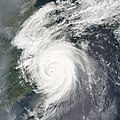
Tập tin:Typhoon Khanun 2005.jpg

Nội dung trang không được hỗ trợ ở ngôn ngữ khác.
Tập tin này từ Wikimedia Commons
Bách khoa toàn thư mở Wikipedia

Tập tin gốc(6.000×6.000 điểm ảnh, kích thước tập tin: 4,48 MB, kiểu MIME: image/jpeg)

Miêu tả

Miêu tả

Typhoon Khanun was poised to make landfall on the coast of mainland China when the Moderate Resolution Imaging Spectroradiometer (MODIS) on NASA’s Terra satellite captured this image at 11:20 a.m. local time, on September 11, 2005. At the time of this MODIS observation, Khanun had sustained winds of 210 kilometers per hour (130 miles per hour).

As Khanun moved in towards China, outflowing wind patterns from the storm pushed away polluted air ahead of it. In the MODIS image, this wind pattern shows up as clear views immediately outside the cloud bands, while smog piles up just beyond the storm’s influence. Khanun is the 15th typhoon to hit China in 2005. The storm is believed to be responsible for 14 reported deaths, mostly from mudslides caused by the heavy rains brought in with the storm system. The land is already saturated from other recent typhoons, so the risk of mudslide events has been unusually high. Nearly one million people were evacuated from coastal areas in the typhoon’s path, including some residents of Shanghai.
Ngày
Nguồn gốc http://earthobservatory.nasa.gov/NaturalHazards/natural_hazards_v2.php3?img_id=13128
Tác giả NASA image created by Jesse Allen, Earth Observatory, using data courtesy of the MODIS Rapid Response team.
Giấy phép
(Dùng lại tập tin)
Public domain This file is in the public domain in the United States because it was solely created by NASA. NASA copyright policy states that "NASA material is not protected by copyright unless noted". (See Template:PD-USGov, NASA copyright policy page or JPL Image Use Policy.)
Warnings:

Chú thích

Ghi một dòng giải thích những gì có trong tập tin này

Khoản mục được tả trong tập tin này

mô tả

Lịch sử tập tin

Nhấn vào ngày/giờ để xem nội dung tập tin tại thời điểm đó.

Ngày/giờHình xem trướcKích cỡThành viênMiêu tả
hiện tại22:56, ngày 6 tháng 9 năm 2006Hình xem trước của phiên bản lúc 22:56, ngày 6 tháng 9 năm 20066.000×6.000 (4,48 MB)Good kitty== Summary == {{Information |Description=Typhoon Khanun was poised to make landfall on the coast of mainland China when the Moderate Resolution Imaging Spectroradiometer (MODIS) on NASA’s Terra satellite captured this image at 11:20 a.m. local time, on
Có 1 trang tại Wikipedia tiếng Việt có liên kết đến tập tin (không hiển thị trang ở các dự án khác):

Sử dụng tập tin toàn cục

Những wiki sau đang sử dụng tập tin này:

Đặc tính hình