Khác biệt giữa bản sửa đổi của “Vùng đô thị Washington”
| Dòng 235: | Dòng 235: | ||
[[Thể loại:Washington, D.C.|*]] |
[[Thể loại:Washington, D.C.|*]] |
||
[[Thể loại:Vùng đô thị Hoa Kỳ| |
[[Thể loại:Vùng đô thị Hoa Kỳ|Washington]] |
||
[[en:Washington Metropolitan Area]] |
[[en:Washington Metropolitan Area]] |
||
Phiên bản lúc 19:35, ngày 24 tháng 1 năm 2009
 Tên thông thường: Vùng đô thị Washington | |
| Thành phố lớn nhất Các thành phố khác |
Washington, D.C. - Arlington - Alexandria |
| Dân số | |
| - Tổng số | 5.306.565 (ước tính 2007.) |
| - Mật độ | /mi2 /km² |
| Diện tích | mi2 km² |
| Các tiểu bang/ Tỉnh/Thành phố |
- Virginia - Maryland - West Virginia |
| Cao độ | |
| - Điểm cao nhất | N/A ft (N/A mét) |
| - Điểm thấp nhất | 0 ft (0 m) |
Vùng đô thị Washington, chính thức được biết như Vùng thống kê đô thị Washington–Arlington–Alexandria, DC–VA–MD–WV, là một vùng thống kê đô thị của Hoa Kỳ do Cục Ngân sách và Quản lý (Office of Management and Budget hay vắn tắc là OMB) định nghĩa. Nó cũng là một phần của Vùng đô thị Baltimore-Washington lớn hơn. Tính đến năm 2007, dân số của Vùng đô thị Washington được ước tính là 5.306.565.[1]
Các cơ quan liên bang khác (như Bộ Nội an Hoa Kỳ) gọi vùng đô thị này là Vùng Thủ đô Quốc gia.[2] Phần khu vực của Virginia được biết đến như Bắc Virginia.
Bộ phận của vùng

Vùng đô thị Washington gồm có Đặc khu Columbia và những phần của các tiểu bang Maryland, Virginia, và West Virginia. Nó được chia thành hai phân vùng đô thị:
- Phân vùng đô thị Washington–Arlington–Alexandria, DC–VA–MD–WV bao gồm phần lớn vùng đô thị này
- Phân vùng đô thị Bethesda–Gaithersburg–Frederick, MD bao gồm các quận Montgomery và Frederick.
Phân cấp hành chính
Khu vực này gồm có các quận, địa khu và thành phố độc lập sau đây:
Đặc khu Columbia

Maryland
Các quận sau đây được xếp như một phần của Vùng thống kê đô thị Washington–Arlington–Alexandria, DC–VA–MD–WV:
Mặc dù có liên hệ với Vùng đô thị Washington, các quận sau đây được xếp như một phần của Vùng thống kê đô thị Baltimore-Towson, MD:
Mặc dù có liên hệ với Vùng đô thị Washington, quận sau đây được xếp như một phần của Vùng thống kê tiểu đô thị Lexington Park, MD:
Virginia
Các quận
- Quận Arlington
- Quận Clarke
- Quận Fairfax
- Quận Fauquier
- Quận Loudoun
- Quận Prince William
- Quận Spotsylvania
- Quận Stafford
- Quận Warren
Các thành phố độc lập:
- Thành phố Alexandria
- City of Fairfax
- Thành phố Falls Church
- Thành phố Fredericksburg
- Thành phố Manassas
- Thành phố Manassas Park
West Virginia
Regional organizations
Metropolitan Washington Council of Governments
Founded in 1957, the Metropolitan Washington Council of Governments (MWCOG) is a regional organization of 21 Washington-area local governments, as well as area members of the Maryland and Virginia state legislatures, the U.S. Senate, and the U.S. House of Representatives. MWCOG provides a forum for discussion and the development of regional responses to issues regarding the environment, transportation, public safety, homeland security, affordable housing, community planning, and economic development.[3]
The National Capital Region Transportation Planning Board, a component of MWCOG, is the federally-designated metropolitan planning organization for the metropolitan Washington area.[4]
Principal cities
The metropolitan area includes the following principal cities (most of which are not incorporated as cities):
- Washington, D.C.
- Arlington, Virginia
- Alexandria, Virginia
- Bethesda, Maryland
- Bowie, Maryland
- Fairfax, Virginia
- Falls Church, Virginia
- Frederick, Maryland
- Gaithersburg, Maryland
- Germantown, Maryland
- Herndon, Virginia
- Leesburg, Virginia
- Manassas, Virginia
- Reston, Virginia
- Rockville, Maryland
- Silver Spring, Maryland
- Tysons Corner, Virginia
- Waldorf, Maryland
Demographics
Composition
Racial composition of the Washington, D.C. area:[5]
- 2006
- 1980
- White : 67.8%
- Black : 26.0%
- Asian : 2.5%
- Hispanic : 2.8%
- Mixed and Other : 0.9%
Educational attainment and affluence
The Washington, D.C. area is the most educated and affluent metropolitan area in the United States.[6] The median household income of the region is $72,800. The two highest median household income counties in the nation, Loudoun and Fairfax County, Virginia, are components of Washington–Arlington–Alexandria. 12.2% of Northern Virginia's 881,136 households, 8.5% of suburban Maryland's 799,300 households, and 8.2% of Washington's 249,805 households have an annual income in excess of $200,000, compared to 3.7% nationally.[7]
As of the 2007 American Community Survey, the three most educated jurisdictions with 200,000 people or more in Washington–Arlington–Alexandria by bachelor's degree attainment (population 25 and over) are Arlington County, Virginia (67.0%), Montgomery County, Maryland (56.5%), and Fairfax County, Virginia (55.9%).[8] Forbes magazine stated in it's 2008 "America's Best- And Worst-Educated Cities" report: "The D.C. area is less than half the size of L.A., but both cities have around 100,000 Ph.D.'s."[9]
Economy


The Washington, D.C. area has the largest science and engineering work force of any metropolitan area in the nation, at 324,530, ahead of the combined San Francisco and San Jose work force of 214,500, and Chicago at 203,090.[12]
Primary industries
Biotechnology
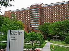
Not limited to its proximity to the National Institutes of Health, Maryland's Washington suburbs are a major center for biotechnology. Prominent local biotech companies include MedImmune, The Institute for Genomic Research, Human Genome Sciences, and the Howard Hughes Medical Institute.
Defense contracting
Many defense contractors are based in the region to be close to the Pentagon in Arlington. Local defense contractors include Lockheed Martin, the largest, as well as General Dynamics, Computer Sciences Corporation (CSC), Science Applications International Corporation (SAIC), and Orbital Sciences Corporation.
Notable company headquarters in the region
(Numbers denote Fortune 500 company ranking.)
Washington, D.C.
- Black Entertainment Television
- Bureau of National Affairs
- Calibre Energy
- Carlyle Group
- Danaher 239
- Federal National Mortgage Association "Fannie Mae" 53
- National Geographic Society
- Pepco Holdings, Inc. 279
- Washington Post Company
- XM Satellite Radio
Suburban Maryland
- BAE Systems Inc. (Rockville)
- Bethesda Softworks (Rockville)
- Chevy Chase Bank (Bethesda)
- Choice Hotels (Silver Spring)
- Coventry Health Care (Bethesda) 226
- Discovery Communications (Silver Spring)
- GEICO (Chevy Chase)
- Host Hotels & Resorts (Bethesda) 440
- Hughes Network Systems (Germantown)
- Lockheed Martin (Bethesda) 57
- Marriott International (Bethesda) 197
- MedImmune (Gaithersburg)
- Radio One (Lanham)
- Ritz Carlton (Chevy Chase)
- TV One (Silver Spring)
Northern Virginia
- AES Corporation (Arlington) 183
- Airbus North America (Herndon)
- BearingPoint (McLean)
- Booz Allen Hamilton (McLean)
- CACI (Arlington)
- Capital One (McLean) 130
- Computer Sciences Corporation (Falls Church) 170
- DynCorp International (Falls Church)
- Federal Home Loan Mortgage Corporation (McLean) "Freddie Mac" 54
- FNH USA (Fredericksburg)
- Gannett Company (McLean) 332
- General Dynamics (Falls Church) 87
- Kellogg Brown and Root Services (Arlington)
- Mars, Incorporated (McLean)
- Navy Federal Credit Union (Vienna)
- NII Holdings(Reston)
- NVR Incorporated (Reston) 464
- Orbital Sciences (Dulles)
- Rolls-Royce North America (Reston)
- Space Adventures (Vienna)
- SLM Corporation (Reston) "Sallie Mae" 286
- USA Today (McLean)
- Verizon Business (Ashburn)
- Volkswagen Group of America (Herndon)
Transportation

Major airports
- Washington Dulles International Airport (Chantilly, Virginia), the busiest in the region
- Ronald Reagan Washington National Airport (Arlington County, Virginia), the closest to Washington
Rail transit systems
- Amtrak (DC, MD, VA, WV)
- Washington Metro (DC, MD, VA)
- MARC Train (DC, MD, WV)
- Virginia Railway Express (DC, VA)
See also
- List of federal agencies in Arlington County, Virginia
- List of people from the Washington, D.C. metropolitan area
- List of U.S. Metropolitan Statistical Areas (MSA) in Virginia
- Potomac primary
Tham khảo
- ^ Metropolitan and Micropolitan Statistical Area Population Estimates Available
- ^ “National Capital Region - Office of National Capital Region Coordination”. Department of Homeland Security. 21 tháng 12 năm 2005. Truy cập ngày 9 tháng 1 năm 2008.
- ^ http://www.mwcog.org/about/
- ^ http://www.mwcog.org/transportation/tpb/
- ^ http://census.gov/popest/counties/asrh/CC-EST2006-RACE6.html
- ^ Washington area richest, most educated in US: report
- ^ ACS 2005-2007
- ^ 2005-2007 American Community Survey 3-Year Estimates
- ^ America's Best- And Worst-Educated Cities
- ^ High-Rises Approved That Would Dwarf D.C.
- ^ List of tallest buildings in DC, MD, VA, WV
- ^ Washington area richest, most educated in US: report
Liên kết ngoài
- OMB Bulletin No. 05-02
- Urban Areas of Virginia
- May 2006 Metropolitan and Nonmetropolitan Area Occupational Employment and Wage Estimates; Washington-Arlington-Alexandria, DC-VA-MD-WV Metropolitan Division
- May 2005 Metropolitan Area Occupational Employment and Wage Estimates; Washington-Arlington-Alexandria, DC-VA-MD-WV Metropolitan Division
- Washington-Arlington-Alexandria, DC-VA-MD-WV MSA Population and Components of Change


