
Tập tin:ATL - FAA airport diagram.png
Kích thước hình xem trước: 391×600 điểm ảnh. Độ phân giải khác: 156×240 điểm ảnh | 313×480 điểm ảnh | 807×1.238 điểm ảnh.
Tập tin gốc (807×1.238 điểm ảnh, kích thước tập tin: 416 kB, kiểu MIME: image/png)
Tập tin này từ Wikimedia Commons. Trang miêu tả nó ở đấy được sao chép dưới đây. Commons là kho lưu trữ tập tin phương tiện có giấy phép tự do. Bạn có thể tham gia. |
Miêu tả
| Miêu tả |
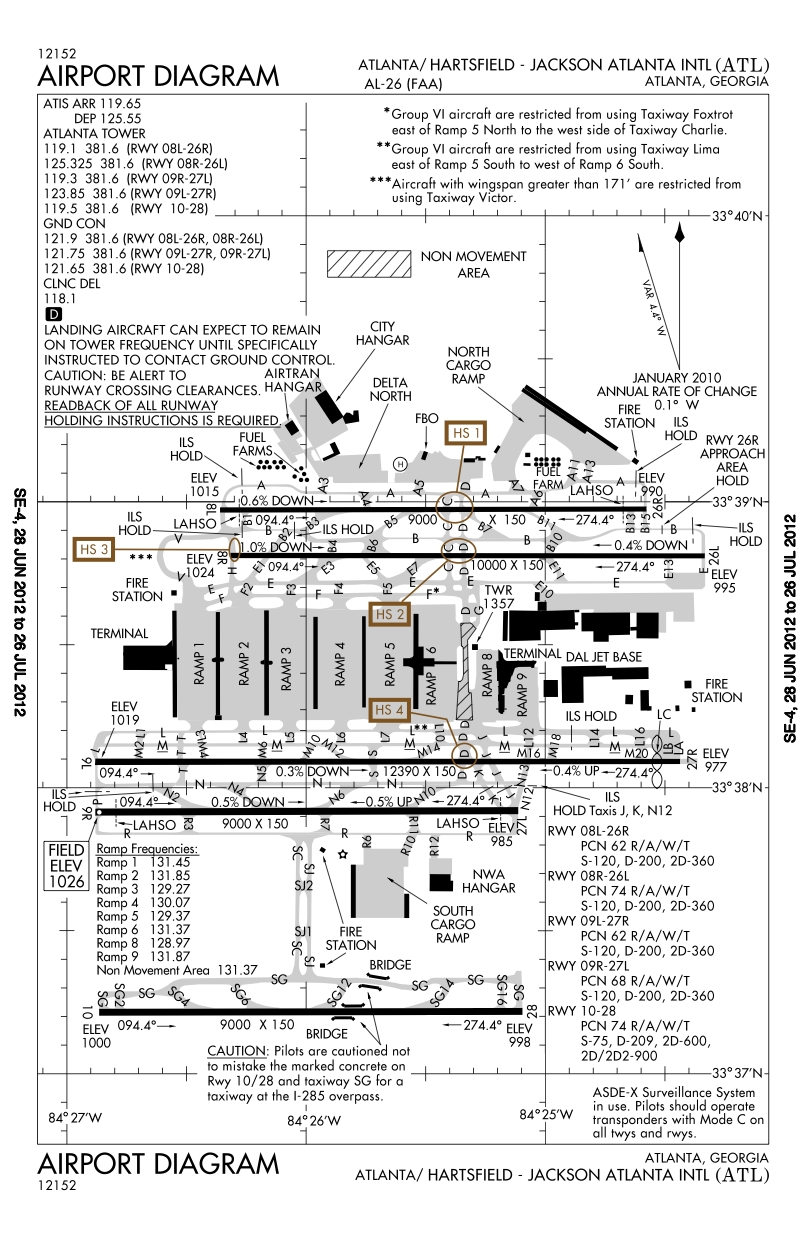
English: FAA airport diagram for Hartsfield-Jackson Atlanta International Airport (ATL) in Atlanta, Georgia, United States. Deutsch: Flughafendiagramm des Flughafens Atlanta
Français : Plan de l'aéroport de la FAA pour Hartsfield-Jackson Atlanta International Airport (ATL) à Atlanta, Géorgie, États-Unis. |
| Ngày | Effective 2007-05-10 to 2007-06-07. |
| Nguồn gốc |
http://aeronav.faa.gov/d-tpp/1110/00026AD.PDF Note: this URL changes every 28 days; the airport article should contain a link to the current FAA diagram. |
| Tác giả | Produced by the National Aeronautical Charting Office (NACO), a department of the Federal Aviation Administration (FAA). |
| Giấy phép (Dùng lại tập tin) |
Public domain. |
| Phiên bản khác |
 |


|
Hiện có một phiên bản với định dạng vector của hình này (SVG).
Nên sử dụng nó thay cho hình raster này khi cần nó chi tiết hơn. File:ATL - FAA airport diagram.png → File:ATL Airport Diagram.svg
Để biết thêm thông tin về đồ họa vector, mời đọc về Chuyển sang SVG của Commons. Cũng có thông tin về sự hỗ trợ hình ảnh SVG của MediaWiki. |
 |
Giấy phép
This image or file is a work of a Federal Aviation Administration employee, taken or made as part of that person's official duties. As a work of the U.S. federal government, the image is in the public domain in the United States.
|
 |
Nhật trình tải lên đầu tiên
Copied from en:Image:Katl-diagram.png on English Wikipedia.
Nhật trình tải lên đầu tiên
| date/time | username | resolution | size | edit summary |
|---|---|---|---|---|
| 02:06, 13 August 2007 | User:TCY | 774×1,188 | 368 KB | == Summary == {{Information | Description = FAA diagram for <a href="/w/index.php?title=Hartsfield-Jackson_Atlanta_International_Airport&action=edit&redlink=1" class="new" title="Hartsfield-Jackson Atlanta International Airport (page does not exist)">Hartsfield-Jackson Atlanta International Airport</a> (ATL) in Atlanta, Georgia, United States. | Source = http://naco.faa.gov/d-tpp/0705/00026AD.PDF<br/>Note: this URL changes monthly, for curren |
Lịch sử tập tin
Nhấn vào ngày/giờ để xem nội dung tập tin tại thời điểm đó.
| Ngày/giờ | Hình xem trước | Kích cỡ | Thành viên | Miêu tả | |
|---|---|---|---|---|---|
| hiện tại | 22:35, ngày 12 tháng 7 năm 2012 | | 807×1.238 (416 kB) | Phongn | Updated to 28 Jun 2012 version |
| 23:20, ngày 7 tháng 7 năm 2008 |  | 774×1.188 (368 kB) | BetacommandBot | move approved by: User:Common Good This image was moved from Image:Katl-diagram.png == Summary == {{Information | Description = FAA airport diagram for [[:en:Hartsfield-Jackson Atlanta International Airport|Hartsfield-Jackson Atlanta Internatio |
Trang sử dụng tập tin
Chưa có trang nào ở Wikipedia tiếng Việt liên kết đến tập tin này.