
Tập tin:Beginning Point of the U.S. Public Land Survey front.jpg

Kích thước hình xem trước: 450×600 điểm ảnh. Độ phân giải khác: 180×240 điểm ảnh | 360×480 điểm ảnh | 576×768 điểm ảnh | 768×1.024 điểm ảnh | 2.112×2.816 điểm ảnh.
Tập tin gốc (2.112×2.816 điểm ảnh, kích thước tập tin: 3,37 MB, kiểu MIME: image/jpeg)
Tập tin này từ Wikimedia Commons. Trang miêu tả nó ở đấy được sao chép dưới đây. Commons là kho lưu trữ tập tin phương tiện có giấy phép tự do. Bạn có thể tham gia. |
|
This is an image of a place or building that is listed on the National Register of Historic Places in the United States of America. Its reference number is 66000606. |
| Vị trí máy chụp hình | | Xem hình này và các hình ảnh lân cận trên: OpenStreetMap |
|---|
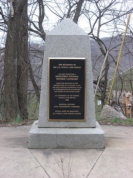
| Miêu tả | Streetside view of the Beginning Point of the U.S. Public Land Survey, a monument marking the site that served as the basis for the entire Public Land Survey System — the system by which most of the United States, outside of the original colonies, was surveyed. Located on the Ohio/Pennsylvania border east of downtown East Liverpool, Ohio, it is split between the city of East Liverpool and the borough of Ohioville in Beaver County, Pennsylvania. Erected in 1881 by a joint commission of Ohio and Pennsylvania surveyors, the monument was declared a National Historic Landmark in 1966. The road on which it lies is Ohio State Route 39 and Pennsylvania Route 68. | ||
| Ngày | Taken on 28 tháng 3 năm 2009 | ||
| Nguồn gốc | Tác phẩm được tạo bởi người tải lên | ||
| Tác giả | User:Nyttend | ||
| Giấy phép (Dùng lại tập tin) |
|
||
| Phiên bản khác |
 Ohio and Ohio and  Pennsylvania sides of the monument Pennsylvania sides of the monument |
Lịch sử tập tin
Nhấn vào ngày/giờ để xem nội dung tập tin tại thời điểm đó.
| Ngày/giờ | Hình xem trước | Kích cỡ | Thành viên | Miêu tả | |
|---|---|---|---|---|---|
| hiện tại | 04:29, ngày 28 tháng 3 năm 2009 | | 2.112×2.816 (3,37 MB) | Nyttend | {{Location|40|38|33|N|80|31|10|W}} {{Information |Description=Streetside view of the {{w|Beginning Point of the U.S. Public Land Survey}}, a monument marking the site that served as the basis for the entire {{w|Public Land Survey System}} — the system b |
Trang sử dụng tập tin
Có 1 trang tại Wikipedia tiếng Việt có liên kết đến tập tin (không hiển thị trang ở các dự án khác):
Sử dụng tập tin toàn cục
Những wiki sau đang sử dụng tập tin này:
- Trang sử dụng tại ca.wikipedia.org
- Trang sử dụng tại de.wikipedia.org
- Trang sử dụng tại en.wikipedia.org
- Public Land Survey System
- List of Historic Civil Engineering Landmarks
- Point of beginning
- List of National Historic Landmarks in Pennsylvania
- List of National Historic Landmarks in Ohio
- Beginning Point of the U.S. Public Land Survey
- National Register of Historic Places listings in Columbiana County, Ohio
- National Register of Historic Places listings in Beaver County, Pennsylvania
- List of Pennsylvania state historical markers in Beaver County
- User talk:Dthomsen8/List PA Test
- Trang sử dụng tại en.wikivoyage.org
- Trang sử dụng tại es.wikipedia.org
- Trang sử dụng tại fr.wikipedia.org
- Trang sử dụng tại hu.wikipedia.org
- Trang sử dụng tại it.wikipedia.org
- Trang sử dụng tại ja.wikipedia.org
- Trang sử dụng tại pt.wikipedia.org
- Trang sử dụng tại tl.wikipedia.org
- Trang sử dụng tại ur.wikipedia.org
- Trang sử dụng tại www.wikidata.org