Tập tin:Dubaiworld.jpg

Kích thước hình xem trước: 780×599 điểm ảnh. Độ phân giải khác: 312×240 điểm ảnh | 625×480 điểm ảnh | 999×768 điểm ảnh | 1.280×984 điểm ảnh | 1.335×1.026 điểm ảnh.
Tập tin gốc (1.335×1.026 điểm ảnh, kích thước tập tin: 811 kB, kiểu MIME: image/jpeg)
Lịch sử tập tin
Nhấn vào ngày/giờ để xem nội dung tập tin tại thời điểm đó.
| Ngày/giờ | Hình xem trước | Kích cỡ | Thành viên | Miêu tả | |
|---|---|---|---|---|---|
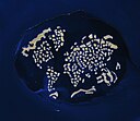
| hiện tại | 07:50, ngày 27 tháng 11 năm 2009 |  | 1.335×1.026 (811 kB) | Wikiarius | {{Information |Description={{en|1=The World Archipelago, Persian Gulf. The image shows the project on February 5, 2009. All the continents are represented (the “map” is tilted toward the left). A breakwater surrounds the archipelago, and its role is |
Trang sử dụng tập tin
Có 1 trang tại Wikipedia tiếng Việt có liên kết đến tập tin (không hiển thị trang ở các dự án khác):
Sử dụng tập tin toàn cục
Những wiki sau đang sử dụng tập tin này:
- Trang sử dụng tại ar.wikipedia.org
- Trang sử dụng tại arz.wikipedia.org
- Trang sử dụng tại ast.wikipedia.org
- Trang sử dụng tại bn.wikipedia.org
- Trang sử dụng tại ca.wikipedia.org
- Trang sử dụng tại ceb.wikipedia.org
- Trang sử dụng tại cs.wikipedia.org
- Trang sử dụng tại en.wikipedia.org
- Trang sử dụng tại eu.wikipedia.org
- Trang sử dụng tại fa.wikipedia.org
- Trang sử dụng tại fi.wikipedia.org
- Trang sử dụng tại fr.wikipedia.org
- Trang sử dụng tại he.wikipedia.org
- Trang sử dụng tại hu.wikipedia.org
- Trang sử dụng tại it.wikipedia.org
- Trang sử dụng tại ja.wikipedia.org
- Trang sử dụng tại ka.wikipedia.org
- Trang sử dụng tại lt.wikipedia.org
- Trang sử dụng tại mg.wikipedia.org
- Trang sử dụng tại nn.wikipedia.org
- Trang sử dụng tại pl.wikipedia.org
- Trang sử dụng tại pt.wikipedia.org
- Trang sử dụng tại ro.wikipedia.org
- Trang sử dụng tại ru.wikipedia.org
- Trang sử dụng tại sk.wikipedia.org
- Trang sử dụng tại sv.wikipedia.org
- Trang sử dụng tại ta.wikipedia.org
- Trang sử dụng tại uk.wikipedia.org
- Trang sử dụng tại www.wikidata.org
- Trang sử dụng tại zh.wikipedia.org


