
Tập tin:Embalse Guri.JPG

Kích thước hình xem trước: 600×600 điểm ảnh. Độ phân giải khác: 240×240 điểm ảnh | 480×480 điểm ảnh | 640×640 điểm ảnh.
Tập tin gốc (640×640 điểm ảnh, kích thước tập tin: 158 kB, kiểu MIME: image/jpeg)
Tập tin này từ Wikimedia Commons. Trang miêu tả nó ở đấy được sao chép dưới đây. Commons là kho lưu trữ tập tin phương tiện có giấy phép tự do. Bạn có thể tham gia. |
Miêu tả
| Miêu tả |
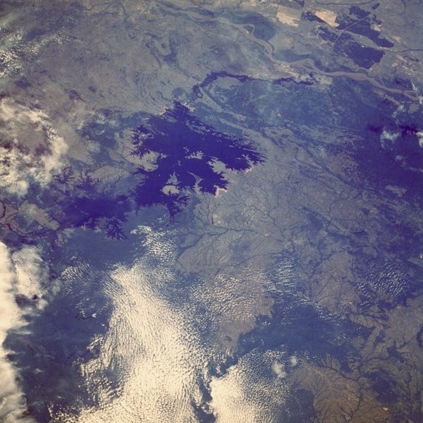
English: The Caroní River and the Guri Reservoir (Venezuela).
Français : La rivière Caroní et le lac de barrage de Guri, au Venezuela. |
| Ngày | |
| Nguồn gốc |
Image Science and Analysis Laboratory, NASA-Johnson Space Center. |
| Tác giả | NASA, Mission: STS61A |
Location of the Guri Dam (Central Hidroeléctrica Simón Bolívar), on the Caroní River
| Vị trí đối tượng | | Xem hình này và các hình ảnh lân cận trên: OpenStreetMap |
|---|
Giấy phép
| This file is in the public domain in the United States because it was solely created by NASA. NASA copyright policy states that "NASA material is not protected by copyright unless noted". (See Template:PD-USGov, NASA copyright policy page or JPL Image Use Policy.) | ||
 |
Warnings:
|
| Annotations | This image is annotated: View the annotations at Commons |

|
This image has been assessed under the valued image criteria and is considered the most valued image on Commons within the scope: Caroní River. You can see its nomination here. |
Lịch sử tập tin
Nhấn vào ngày/giờ để xem nội dung tập tin tại thời điểm đó.
| Ngày/giờ | Hình xem trước | Kích cỡ | Thành viên | Miêu tả | |
|---|---|---|---|---|---|
| hiện tại | 13:06, ngày 17 tháng 10 năm 2005 | | 640×640 (158 kB) | Venex | Imagen del Embalse de Guri en Venezuela desde el espacio. |
Trang sử dụng tập tin
Có 2 trang tại Wikipedia tiếng Việt có liên kết đến tập tin (không hiển thị trang ở các dự án khác):
Sử dụng tập tin toàn cục
Những wiki sau đang sử dụng tập tin này:
- Trang sử dụng tại be.wikipedia.org
- Trang sử dụng tại ca.wikipedia.org
- Trang sử dụng tại de.wikipedia.org
- Trang sử dụng tại en.wikipedia.org
- Trang sử dụng tại es.wikipedia.org
- Trang sử dụng tại eu.wikipedia.org
- Trang sử dụng tại fr.wikipedia.org
- Trang sử dụng tại hr.wikipedia.org
- Trang sử dụng tại ig.wikipedia.org
- Trang sử dụng tại lt.wikipedia.org
- Trang sử dụng tại nl.wikipedia.org
- Trang sử dụng tại pt.wikipedia.org
- Trang sử dụng tại qu.wikipedia.org
- Trang sử dụng tại ru.wikipedia.org
- Trang sử dụng tại sh.wikipedia.org
- Trang sử dụng tại sl.wikipedia.org
- Trang sử dụng tại uk.wikipedia.org
- Trang sử dụng tại www.wikidata.org
- Trang sử dụng tại zh.wikipedia.org