
Tập tin:Pluto-map-hs-2010-06-d270.jpg

Kích thước hình xem trước: 600×600 điểm ảnh. Độ phân giải khác: 240×240 điểm ảnh | 480×480 điểm ảnh | 768×768 điểm ảnh | 1.200×1.200 điểm ảnh.
Tập tin gốc (1.200×1.200 điểm ảnh, kích thước tập tin: 196 kB, kiểu MIME: image/jpeg)
Tập tin này từ Wikimedia Commons. Trang miêu tả nó ở đấy được sao chép dưới đây. Commons là kho lưu trữ tập tin phương tiện có giấy phép tự do. Bạn có thể tham gia. |
| Miêu tả |
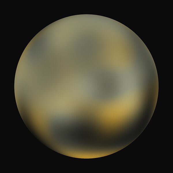
English: A best-fit color image/map of Pluto generated with the Hubble Space Telescope and advanced computers. It is unknown if the brightness differences are mountains, craters, or polar caps. |
|||||
| Ngày | ||||||
| Nguồn gốc | http://hubblesite.org/newscenter/archive/releases/2010/06/image/d/ | |||||
| Tác giả | NASA, ESA, and Marc W. Buie (Southwest Research Institute) | |||||
| Giấy phép (Dùng lại tập tin) |
Any web pages, publications, or any other published use of these maps should provide a legible credit line consistent with the medium that states: "Images are courtesy of Marc W. Buie, Southwest Research Institute"
|
|||||
| Phiên bản khác | Pluto-map-hs-2010-06-b90.jpg, Pluto-map-hs-2010-06-c180.jpg |

Lịch sử tập tin
Nhấn vào ngày/giờ để xem nội dung tập tin tại thời điểm đó.
| Ngày/giờ | Hình xem trước | Kích cỡ | Thành viên | Miêu tả | |
|---|---|---|---|---|---|
| hiện tại | 08:46, ngày 5 tháng 2 năm 2010 | | 1.200×1.200 (196 kB) | Kwamikagami | {{Information |Description={{en|1=A best-fit color image/map of Pluto generated with the Hubble Space Telescope and advanced computers. It is unknown if the brightness differences are mountains, craters, or polar caps.}} |Source=http://hubblesite.org/news |
Trang sử dụng tập tin
Chưa có trang nào ở Wikipedia tiếng Việt liên kết đến tập tin này.
Sử dụng tập tin toàn cục
Những wiki sau đang sử dụng tập tin này:
- Trang sử dụng tại en.wikipedia.org