
Tập tin:Sudbury Wanapitei WorldWind.jpg

Kích thước hình xem trước: 800×600 điểm ảnh. Độ phân giải khác: 320×240 điểm ảnh | 640×480 điểm ảnh | 1.024×768 điểm ảnh.
Tập tin gốc (1.024×768 điểm ảnh, kích thước tập tin: 308 kB, kiểu MIME: image/jpeg)
Tập tin này từ Wikimedia Commons. Trang miêu tả nó ở đấy được sao chép dưới đây. Commons là kho lưu trữ tập tin phương tiện có giấy phép tự do. Bạn có thể tham gia. |
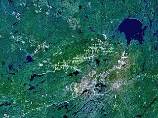
| Miêu tả | The Sudbury and Wanapitei impact craters in Ontario, Canada. Sudbury is the large, elliptical structure (60 x 30 km); Wanapitei is the lake filled crater at upper right. Its diameter is 8km, its age 37 million years. |
| Nguồn gốc | Created with NASA WorldWind by User:Vesta using Landsat 7 (Visible Color) satellite image. |
| Tác giả | User:Vesta |
46°36′0″N 81°11′0″W / 46.6°N 81.18333°W
| This image is in the public domain because it is a screenshot from NASA’s globe software World Wind using a public domain layer, such as Blue Marble, MODIS, Landsat, SRTM, USGS or GLOBE.
|
 |
Lịch sử tập tin
Nhấn vào ngày/giờ để xem nội dung tập tin tại thời điểm đó.
| Ngày/giờ | Hình xem trước | Kích cỡ | Thành viên | Miêu tả | |
|---|---|---|---|---|---|
| hiện tại | 09:52, ngày 7 tháng 1 năm 2006 | | 1.024×768 (308 kB) | Vesta~commonswiki | * '''Description:''' The Sudbury and Wanapitei impact craters in Ontario, Canada. Sudbury is the large, elliptical structure (60 x 30 km), Wanapitei is the lake filled crater at upper right. *'''Source:''' Created with NASA WorldWind by User:Vesta usi |
Trang sử dụng tập tin
Có 1 trang tại Wikipedia tiếng Việt có liên kết đến tập tin (không hiển thị trang ở các dự án khác):
Sử dụng tập tin toàn cục
Những wiki sau đang sử dụng tập tin này:
- Trang sử dụng tại af.wikipedia.org
- Trang sử dụng tại ar.wikipedia.org
- Trang sử dụng tại ca.wikipedia.org
- Trang sử dụng tại ceb.wikipedia.org
- Trang sử dụng tại cs.wikipedia.org
- Trang sử dụng tại de.wikipedia.org
- Trang sử dụng tại en.wikipedia.org
- Trang sử dụng tại es.wikipedia.org
- Trang sử dụng tại eu.wikipedia.org
- Trang sử dụng tại fa.wikipedia.org
- Trang sử dụng tại fr.wikipedia.org
- Trang sử dụng tại he.wikipedia.org
- Trang sử dụng tại hu.wikipedia.org
- Trang sử dụng tại id.wikipedia.org
- Trang sử dụng tại it.wikipedia.org
- Trang sử dụng tại ja.wikipedia.org
- Trang sử dụng tại kw.wikipedia.org
- Trang sử dụng tại nl.wikipedia.org
- Trang sử dụng tại ro.wikipedia.org
- Trang sử dụng tại ru.wikipedia.org
- Trang sử dụng tại simple.wikipedia.org
- Trang sử dụng tại sk.wikipedia.org
- Trang sử dụng tại tr.wikipedia.org
- Trang sử dụng tại uk.wikipedia.org
- Trang sử dụng tại uz.wikipedia.org
- Trang sử dụng tại www.wikidata.org
- Trang sử dụng tại zh.wikipedia.org