
Tập tin:Trafalgar 1200hr.gif
Kích thước hình xem trước: 635×600 điểm ảnh. Độ phân giải khác: 254×240 điểm ảnh | 508×480 điểm ảnh | 900×850 điểm ảnh.
Tập tin gốc (900×850 điểm ảnh, kích thước tập tin: 30 kB, kiểu MIME: image/gif)
Tập tin này từ Wikimedia Commons. Trang miêu tả nó ở đấy được sao chép dưới đây. Commons là kho lưu trữ tập tin phương tiện có giấy phép tự do. Bạn có thể tham gia. |

|
This file has been superseded by Trafalgar 1200hr.svg. It is recommended to use the other file. Please note that deleting superseded images requires consent. Reason to use the other file: "The new file is SVG, and has less spelling mistakes"
|

|
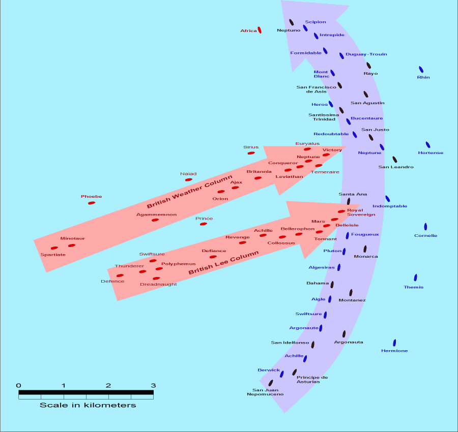
- Description: This map of the Battle of Trafalgar shows the approximate position of the two fleets at 1200 hours during the battle as the Royal Sovereign was breaking into the Franco-Spanish line. North is to the top, and Cape Trafalgar is 10 miles to the northeast.
- Size: 900 × 850 pixels.
- Source: This drawing is based on an illustration in issue number 84 of the Strategy & Tactics magazine The map was made by RJHall using the Campaign Cartographer drawing program, and the image was reduced in size 50% in Paint Shop Pro. Ship icons are not to scale.
Tập tin này được phát hành theo Giấy phép Creative Commons Ghi công–Chia sẻ tương tự 2.5 Chung
- Bạn được phép:
- chia sẻ – sao chép, phân phối và chuyển giao tác phẩm
- pha trộn – để chuyển thể tác phẩm
- Theo các điều kiện sau:
- ghi công – Bạn phải ghi lại tác giả và nguồn, liên kết đến giấy phép, và các thay đổi đã được thực hiện, nếu có. Bạn có thể làm các điều trên bằng bất kỳ cách hợp lý nào, miễn sao không ám chỉ rằng người cho giấy phép ủng hộ bạn hay việc sử dụng của bạn.
- chia sẻ tương tự – Nếu bạn biến tấu, biến đổi, hoặc làm tác phẩm khác dựa trên tác phẩm này, bạn chỉ được phép phân phối tác phẩm mới theo giấy phép y hệt hoặc tương thích với tác phẩm gốc.
Lịch sử tập tin
Nhấn vào ngày/giờ để xem nội dung tập tin tại thời điểm đó.
| Ngày/giờ | Hình xem trước | Kích cỡ | Thành viên | Miêu tả | |
|---|---|---|---|---|---|
| hiện tại | 14:30, ngày 28 tháng 7 năm 2005 | | 900×850 (30 kB) | RJHall | Battle of Trafalgar situation at 1200hr, 21 October 1805. |
Trang sử dụng tập tin
Chưa có trang nào ở Wikipedia tiếng Việt liên kết đến tập tin này.
Sử dụng tập tin toàn cục
Những wiki sau đang sử dụng tập tin này:
- Trang sử dụng tại fr.wikipedia.org
- Trang sử dụng tại ja.wikipedia.org