
Tập tin:WW2-Holocaust-ROstland.PNG
Không có độ phân giải cao hơn.
WW2-Holocaust-ROstland.PNG (442×418 điểm ảnh, kích thước tập tin: 145 kB, kiểu MIME: image/png)
Tập tin này từ Wikimedia Commons. Trang miêu tả nó ở đấy được sao chép dưới đây. Commons là kho lưu trữ tập tin phương tiện có giấy phép tự do. Bạn có thể tham gia. |
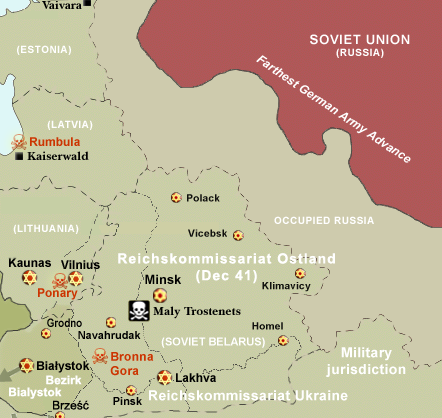
Miêu tả
| Miêu tả |
Map of the Holocaust in Reichskommissariat Ostland (Belarus and the Baltic States) during World War II, 1939-1945. This map shows all extermination camps (or death camps), most major concentration camps, labor camps, prison camps, ghettos, major deportation routes and major massacre sites. Notes: 1. Extermination camps were dedicated death camps, but all camps and ghettos took a toll of many, many lives. 2. Concentration camps include labor camps, prison camps & transit camps. 3. Not all camps & ghettos are shown. 4. Borders are at the height of Axis domination (1942). 5. Some regions have German designations (e.g. "Ostland"), with the present country name denoted in uppercase letters in parenthesis below the German designation (e.g. "(AUSTRIA)"). 6. Present (2007) borders are dotted. |
| Ngày | (UTC) |
| Nguồn gốc | |
| Tác giả | |
| Giấy phép (Dùng lại tập tin) |
CC, see below. The map is completely unrestricted for any Wikipedia/Wikimedia project. |
| Phiên bản khác |
 Derivative works of this file: WW2-Holocaust-Poland.PNGImage:WW2-Holocaust-Europe-2007Borders.png (present (2007) borders). If you have any opinions/suggestions, please contact me here on my talk page. |

|
Hình ảnh thuộc thể loại "historical map" cần được vẽ lại bằng đồ họa vector theo định dạng tập tin SVG. Để biết ưu điểm của định dạng này, hãy đọc Commons:Media for cleanup. Nếu tập tin này đã có SVG, xin hãy tải lên đây rồi thay bản mẫu này bằng {{vector version available|tên hình mới.svg}}.
|
Giấy phép
I, Dennis Nilsson, người giữ bản quyền tác phẩm này, từ đây phát hành nó theo giấy phép sau:
Tập tin này được phát hành theo Giấy phép Creative Commons Ghi công 3.0 Chưa chuyển đổi
Ghi công: I, Dennis Nilsson
- Bạn được phép:
- chia sẻ – sao chép, phân phối và chuyển giao tác phẩm
- pha trộn – để chuyển thể tác phẩm
- Theo các điều kiện sau:
- ghi công – Bạn phải ghi lại tác giả và nguồn, liên kết đến giấy phép, và các thay đổi đã được thực hiện, nếu có. Bạn có thể làm các điều trên bằng bất kỳ cách hợp lý nào, miễn sao không ám chỉ rằng người cho giấy phép ủng hộ bạn hay việc sử dụng của bạn.
- derivative work: Piotr Konieczny aka Prokonsul Piotrus Talk
|Permission= |other_versions= }}
| Đây là một ảnh đã được chỉnh sửa, có nghĩa là nó đã được chỉnh sửa kỹ thuật số so với phiên bản gốc. Các chỉnh sửa: Belarus and Baltic States only. Có thể xem phiên bản gốc tại đây: WW2-Holocaust-Europe.png.
|
Tôi, người giữ bản quyền tác phẩm này, từ đây phát hành nó theo giấy phép sau:
Tập tin này được phát hành theo Giấy phép Creative Commons Ghi công 3.0 Chưa chuyển đổi
- Bạn được phép:
- chia sẻ – sao chép, phân phối và chuyển giao tác phẩm
- pha trộn – để chuyển thể tác phẩm
- Theo các điều kiện sau:
- ghi công – Bạn phải ghi lại tác giả và nguồn, liên kết đến giấy phép, và các thay đổi đã được thực hiện, nếu có. Bạn có thể làm các điều trên bằng bất kỳ cách hợp lý nào, miễn sao không ám chỉ rằng người cho giấy phép ủng hộ bạn hay việc sử dụng của bạn.
Nhật trình tải lên đầu tiên
This image is a derivative work of the following images:
- File:WW2-Holocaust-Europe.png licensed with Cc-by-3.0
- 2007-12-20T03:41:38Z Dna-webmaster 1310x1090 (845818 Bytes) new version without "Axis cooperating" in legend
- 2007-12-20T02:00:30Z Dna-webmaster 1310x1090 (844034 Bytes) Now entire West Prussia and Wartheland is included in the Third Reich
- 2007-12-19T16:42:15Z Dna-webmaster 1310x1090 (847461 Bytes) still not Da Vinci, but errors have been corrected (Germany borders West/East), West & East Prussia borders/coloring and Poland General Government corrected borders.
- 2007-12-17T10:46:28Z Dna-webmaster 1310x1090 (844633 Bytes) new map with 1942 borders, not Da Vinci, but here it goes...
- 2007-10-19T13:32:25Z Dna-webmaster 1310x1090 (784727 Bytes) and another update
- 2007-10-19T12:21:52Z Dna-webmaster 1310x1090 (789383 Bytes) quick fix
- 2007-10-19T12:11:07Z Dna-webmaster 1310x1090 (789413 Bytes) {{Information |Description=Map of the Holocaust in Europe during World War II, 1939-1945. This map shows all extermination camps (or ''death camps''), most major concentration camps, work camps, prison camps, ghettos, major
Uploaded with derivativeFX' '
Lịch sử tập tin
Nhấn vào ngày/giờ để xem nội dung tập tin tại thời điểm đó.
| Ngày/giờ | Hình xem trước | Kích cỡ | Thành viên | Miêu tả | |
|---|---|---|---|---|---|
| hiện tại | 16:51, ngày 29 tháng 7 năm 2016 | | 442×418 (145 kB) | Poeticbent | file reloaded, cache promblems |
| 16:44, ngày 29 tháng 7 năm 2016 |  | 442×418 (145 kB) | Poeticbent | missing elements including locations | |
| 19:25, ngày 5 tháng 9 năm 2013 |  | 442×418 (131 kB) | Poeticbent | most obvious error, Lithuania was never part of Reichskommissariat Ostland, neither was Bialystok, added names of major cities | |
| 18:44, ngày 2 tháng 11 năm 2009 |  | 442×418 (90 kB) | Flying Saucer | Vaivara | |
| 19:32, ngày 19 tháng 2 năm 2009 |  | 442×418 (90 kB) | Piotrus | {{Information |Description=Map of the Holocaust in Reichskommissariat Ostland (Belarus and the Baltic States) during World War II, 1939-1945. <br> This map shows all extermination camps (or ''death camps''), most major concentration camps, labor camps, pr |
Trang sử dụng tập tin
Có 1 trang tại Wikipedia tiếng Việt có liên kết đến tập tin (không hiển thị trang ở các dự án khác):
Sử dụng tập tin toàn cục
Những wiki sau đang sử dụng tập tin này:
- Trang sử dụng tại be-tarask.wikipedia.org
- Trang sử dụng tại da.wikipedia.org
- Trang sử dụng tại de.wikipedia.org
- Trang sử dụng tại el.wikipedia.org
- Trang sử dụng tại en.wikipedia.org
- Trang sử dụng tại es.wikipedia.org
- Trang sử dụng tại fa.wikipedia.org
- Trang sử dụng tại fi.wikipedia.org
- Trang sử dụng tại fr.wikipedia.org
- Trang sử dụng tại fy.wikipedia.org
- Trang sử dụng tại he.wikipedia.org
- Trang sử dụng tại it.wikipedia.org
- Trang sử dụng tại ja.wikipedia.org
- Trang sử dụng tại mk.wikipedia.org
- Trang sử dụng tại nl.wikipedia.org
- Trang sử dụng tại no.wikipedia.org
- Trang sử dụng tại pl.wikipedia.org
- Trang sử dụng tại pt.wikipedia.org
- Trang sử dụng tại ro.wikipedia.org
- Trang sử dụng tại sr.wikipedia.org
- Trang sử dụng tại sv.wikipedia.org
- Trang sử dụng tại tr.wikipedia.org
- Trang sử dụng tại zh.wikipedia.org