
Tập tin:Congo regions named.png
Không có độ phân giải cao hơn.
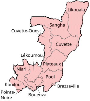
Congo_regions_named.png (300×337 điểm ảnh, kích thước tập tin: 14 kB, kiểu MIME: image/png)
Tập tin này từ Wikimedia Commons. Trang miêu tả nó ở đấy được sao chép dưới đây. Commons là kho lưu trữ tập tin phương tiện có giấy phép tự do. Bạn có thể tham gia. |
| Miêu tả |
Map of the regions of the Republic of the Congo, named in French (local language), mostly compatible with English. The individual maps are: |
| Ngày | |
| Nguồn gốc | Self-made, traced from public domain UN or CIA maps. |
| Tác giả | User:Golbez |
| Giấy phép (Dùng lại tập tin) |
Provide attribution, please. See below. |
Tôi, người giữ bản quyền tác phẩm này, từ đây phát hành nó theo các giấy phép sau:
Tác phẩm này được phát hành theo giấy phép Creative Commons Ghi công–Chia sẻ tương tự, các phiên bản 2.5 Chung, 2.0 Chung, và 1.0 Chung.
- Bạn được phép:
- chia sẻ – sao chép, phân phối và chuyển giao tác phẩm
- pha trộn – để chuyển thể tác phẩm
- Theo các điều kiện sau:
- ghi công – Bạn phải ghi lại tác giả và nguồn, liên kết đến giấy phép, và các thay đổi đã được thực hiện, nếu có. Bạn có thể làm các điều trên bằng bất kỳ cách hợp lý nào, miễn sao không ám chỉ rằng người cho giấy phép ủng hộ bạn hay việc sử dụng của bạn.
- chia sẻ tương tự – Nếu bạn biến tấu, biến đổi, hoặc làm tác phẩm khác dựa trên tác phẩm này, bạn chỉ được phép phân phối tác phẩm mới theo giấy phép y hệt hoặc tương thích với tác phẩm gốc.

|
Bạn có quyền sao chép, phân phối và/hoặc sửa đổi tài liệu này theo những điều khoản được quy định trong Giấy phép Tài liệu Tự do GNU, phiên bản 1.2 hoặc các phiên bản mới hơn được Quỹ Phần mềm Tự do; quy định; ngoại trừ những phần không được sửa đổi, bìa trước và bìa sau. Bạn có thể xem giấy phép nói trên ở phần Giấy phép Tài liệu Tự do GNU. |
| Tập tin này được phát hành theo Giấy phép Creative Commons Ghi công - Chia sẻ tương tự 3.0 Chưa chuyển đồi | ||
| ||
| Thẻ quyền này được thêm vào tập tin trong khi cập nhật giấy phép GFDL. |
Bạn có thể chọn giấy phép mà bạn muốn.
Lịch sử tập tin
Nhấn vào ngày/giờ để xem nội dung tập tin tại thời điểm đó.
| Ngày/giờ | Hình xem trước | Kích cỡ | Thành viên | Miêu tả | |
|---|---|---|---|---|---|
| hiện tại | 17:29, ngày 1 tháng 10 năm 2023 | | 300×337 (14 kB) | Yunan973 | fix all boundaries according to last offical maps (2023) |
| 16:53, ngày 28 tháng 12 năm 2004 |  | 300×370 (13 kB) | Golbez | Map of the regions of the Republic of the Congo. Made by User:Golbez. {{cc-by-sa-2.0}} |
Trang sử dụng tập tin
Có 1 trang tại Wikipedia tiếng Việt có liên kết đến tập tin (không hiển thị trang ở các dự án khác):
Sử dụng tập tin toàn cục
Những wiki sau đang sử dụng tập tin này:
- Trang sử dụng tại ast.wikipedia.org
- Trang sử dụng tại avk.wikipedia.org
- Trang sử dụng tại be-tarask.wikipedia.org
- Trang sử dụng tại bg.wikipedia.org
- Trang sử dụng tại bn.wikipedia.org
- Trang sử dụng tại br.wikipedia.org
- Trang sử dụng tại ca.wikipedia.org
- Trang sử dụng tại de.wikipedia.org
- Trang sử dụng tại el.wikipedia.org
- Trang sử dụng tại en.wikipedia.org
- Departments of the Republic of the Congo
- Pointe-Noire
- Districts of the Republic of the Congo
- User:Jonny-mt/Gallery of current first-level administrative country subdivisions maps
- Kimongo District
- Mayoko District
- Divénié District
- Louvakou District
- Template:Districts of the Republic of the Congo
- User talk:Markussep/Archive 4
- Kibangou District
- Moutamba District
- Boko-Songho District
- Loudima District
- Madingou District
- Mfouati District
- Mouyondzi District
- Kayes District
- Boundji District
- Loukela District
- Makoua District
- Mossaka District
- Okoyo District
- Oyo District
- Ewo District
- Kelle District
- Mbomo District
- Kakamoeka District
- Madingo-Kayes District
- Mvouti District
- Bambama District
- Komono District
- Sibiti District
- Zanaga District
- Dongou District
- Epena District
- Impfondo District
Xem thêm các trang toàn cục sử dụng tập tin này.