
Tập tin:Demis-kurils-russian names.png
Không có độ phân giải cao hơn.
Demis-kurils-russian_names.png (663×462 điểm ảnh, kích thước tập tin: 70 kB, kiểu MIME: image/png)
Tập tin này từ Wikimedia Commons. Trang miêu tả nó ở đấy được sao chép dưới đây. Commons là kho lưu trữ tập tin phương tiện có giấy phép tự do. Bạn có thể tham gia. |
Miêu tả
| Miêu tả |
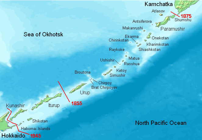
English: Kuril Islands overview map with current Russian names (English transliteration). Borders of Shimoda Treaty (1855) and Treaty of St. Petersburg (1875) shown in red. Currently all islands northeast of Hokkaido are administered by Russia. Note: Ushishir actually consists of 2 islands: Ryponkicha (northeast) and Yankicha (southwest).
Bahasa Indonesia: Peta yang menampilkan nama-nama pulau di Kepulauan Kuril dalam bahasa Rusia (transliterasi Inggris). Perbatasan dalam Traktat Shimoda (1855) dan Traktat Sankt-Peterburg (1875) ditunjukkan dalam warna merah. Sekarang semua pulau-pulau di timur laut Hokkaido dikuasai oleh Rusia. Catatan: Ushishir sebenarnya terdiri dari 2 pulau: Ryponkicha (timur laut) dan Yankicha (barat daya). |
| Ngày | |
| Nguồn gốc | Tác phẩm được tạo bởi người tải lên |
| Tác giả | Hardscarf |
| Phiên bản khác |
|

Giấy phép
This image is in the public domain because it came from the site https://www.demis.nl/products/web-map-server/examples/ and was released by the copyright holder. Permission is granted to copy, distribute and/or modify this map since it is based on free of copyright images from: www.demis.nl. See also approval email on de.wp and its clarification.
|
| This work has been released into the public domain by its copyright holder, www.demis.nl. This applies worldwide. Tại một quốc gia mà luật pháp không cho phép điều này, thì: www.demis.nl cho phép tất cả mọi người được quyền sử dụng tác phẩm này với bất cứ mục đích nào, không kèm theo bất kỳ điều kiện nào, trừ phi luật pháp yêu cầu những điều kiện đó.
|
Lịch sử tập tin
Nhấn vào ngày/giờ để xem nội dung tập tin tại thời điểm đó.
| Ngày/giờ | Hình xem trước | Kích cỡ | Thành viên | Miêu tả | |
|---|---|---|---|---|---|
| hiện tại | 18:27, ngày 22 tháng 5 năm 2008 | | 663×462 (70 kB) | ChrisDHDR | added the border since 1945 |
| 20:00, ngày 23 tháng 11 năm 2006 |  | 663×462 (70 kB) | Hardscarf | Kuril Islands overviewmap with actual Russian names (English transliteration). Borders of Shimoda Treaty (1855) and Treaty of St. Petersburg (1875) shown in red. Currently all islands northwest of Hokkaido are administered by Russia. Note: Ushishir actua |
Trang sử dụng tập tin
Có 4 trang tại Wikipedia tiếng Việt có liên kết đến tập tin (không hiển thị trang ở các dự án khác):
Sử dụng tập tin toàn cục
Những wiki sau đang sử dụng tập tin này:
- Trang sử dụng tại ace.wikipedia.org
- Trang sử dụng tại af.wikipedia.org
- Trang sử dụng tại ar.wikipedia.org
- Trang sử dụng tại az.wikipedia.org
- Trang sử dụng tại be.wikipedia.org
- Trang sử dụng tại bg.wikipedia.org
- Trang sử dụng tại br.wikipedia.org
- Trang sử dụng tại ca.wikipedia.org
- Trang sử dụng tại ckb.wikipedia.org
- Trang sử dụng tại cs.wikipedia.org
- Trang sử dụng tại da.wikipedia.org
- Trang sử dụng tại de.wikipedia.org
- Kurilen
- Vierte Kurilenstraße
- Kurilenstraße
- Zweite Kurilenstraße
- Nemuro-Straße
- Fries-Straße
- Luschin-Straße
- Krusenstern-Straße
- Jekaterina-Straße
- Boussole-Straße
- Kurilenstraßen
- Nadeschda-Straße
- 27. Armee (Japanisches Kaiserreich)
- 91. Division (Japanisches Kaiserreich)
- 5. Regionalarmee
- Juli 1990
- Vorlage:Navigationsleiste Kurilenstraßen
- Trang sử dụng tại en.wikipedia.org
- Trang sử dụng tại en.wiktionary.org
- Trang sử dụng tại es.wikipedia.org
Xem thêm các trang toàn cục sử dụng tập tin này.