
Tập tin:Demre,Turkey.jpg
Không có độ phân giải cao hơn.
Demre,Turkey.jpg (720×480 điểm ảnh, kích thước tập tin: 212 kB, kiểu MIME: image/jpeg)
Tập tin này từ Wikimedia Commons. Trang miêu tả nó ở đấy được sao chép dưới đây. Commons là kho lưu trữ tập tin phương tiện có giấy phép tự do. Bạn có thể tham gia. |
| Miêu tả |
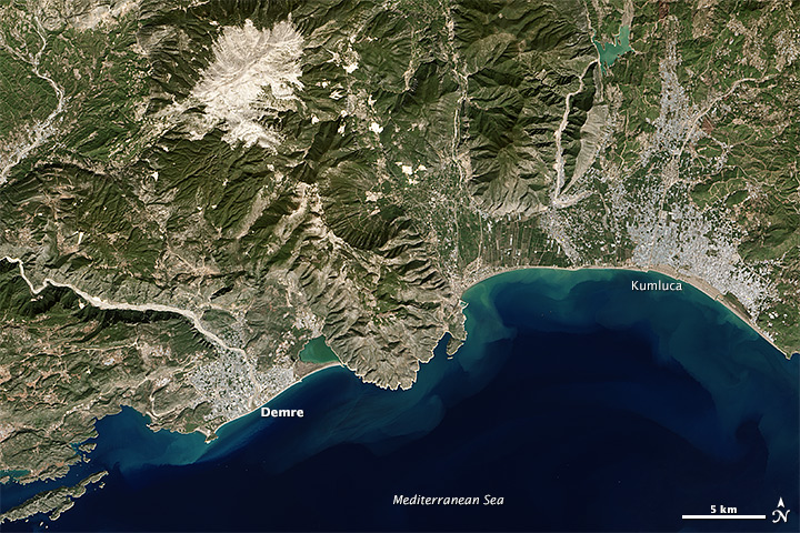
English: The Operational Land Imager on the Landsat 8 satellite acquired this image of the southwest Turkish coast on October 20, 2013. The river Demre cuts through the city, while the Taurus Mountains stand to the north and east. The town of Kumluca meets the coast east of the mountains. |
|||||
| Ngày | acquired October 20, 2013 | |||||
| Nguồn gốc | http://earthobservatory.nasa.gov/IOTD/view.php?id=82652&src=eoa-iotd | |||||
| Tác giả | Jesse Allen and Robert Simmon | |||||
| Giấy phép (Dùng lại tập tin) |
|

Lịch sử tập tin
Nhấn vào ngày/giờ để xem nội dung tập tin tại thời điểm đó.
| Ngày/giờ | Hình xem trước | Kích cỡ | Thành viên | Miêu tả | |
|---|---|---|---|---|---|
| hiện tại | 07:57, ngày 1 tháng 1 năm 2014 | | 720×480 (212 kB) | Tillman | {{Information |Description ={{en|1=The Operational Land Imager on the Landsat 8 satellite acquired this image of the southwest Turkish coast on October 20, 2013. The river Demre cuts through the city, while the Taurus Mountains stand to the north an... |
Trang sử dụng tập tin
Có 1 trang tại Wikipedia tiếng Việt có liên kết đến tập tin (không hiển thị trang ở các dự án khác):
Sử dụng tập tin toàn cục
Những wiki sau đang sử dụng tập tin này: