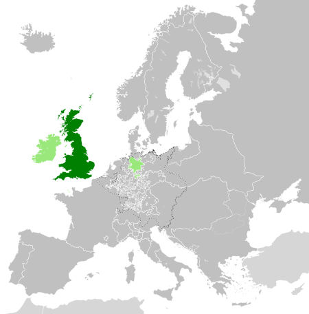
Tập tin:Great Britain 1789.svg

Kích thước bản xem trước PNG này của tập tin SVG: 450×456 điểm ảnh. Độ phân giải khác: 237×240 điểm ảnh | 474×480 điểm ảnh | 758×768 điểm ảnh | 1.011×1.024 điểm ảnh | 2.021×2.048 điểm ảnh.
Tập tin gốc (tập tin SVG, 450×456 điểm ảnh trên danh nghĩa, kích thước: 848 kB)
Lịch sử tập tin
Nhấn vào ngày/giờ để xem nội dung tập tin tại thời điểm đó.
| Ngày/giờ | Hình xem trước | Kích cỡ | Thành viên | Miêu tả | |
|---|---|---|---|---|---|
| hiện tại | 16:42, ngày 19 tháng 12 năm 2023 |  | 450×456 (848 kB) | Iktsokh | Cyprus paler grey |
| 11:17, ngày 26 tháng 5 năm 2022 |  | 450×456 (846 kB) | Cyygma | Changing pale green to light green (more visible) | |
| 08:08, ngày 17 tháng 10 năm 2021 |  | 450×456 (846 kB) | Fenn-O-maniC | Fixed the Russo-Swedish border to match the Treaty of Åbo of 1743 | |
| 16:20, ngày 5 tháng 9 năm 2017 |  | 450×456 (857 kB) | Alphathon | Danzig | |
| 15:55, ngày 5 tháng 9 năm 2017 |  | 450×456 (840 kB) | Alphathon | Added Brunswick-Lüneburg to British domains as it was rules in a personal union | |
| 15:45, ngày 5 tháng 9 năm 2017 |  | 450×456 (840 kB) | Alphathon | Made Asia paler grey | |
| 15:34, ngày 5 tháng 9 năm 2017 |  | 450×456 (840 kB) | Alphathon | == {{int:filedesc}} == {{Information |Description={{en|A map of the en:Kingdom of Great Britain circa 1789. Other British-held territories (Ireland, Mann, Channel Islands) are also shown in pale green.}}{{de|Eine Karte des [[:de:Königreich Groß... |
Trang sử dụng tập tin
Có 2 trang tại Wikipedia tiếng Việt có liên kết đến tập tin (không hiển thị trang ở các dự án khác):
Sử dụng tập tin toàn cục
Những wiki sau đang sử dụng tập tin này:
- Trang sử dụng tại azb.wikipedia.org
- Trang sử dụng tại bn.wikipedia.org
- Trang sử dụng tại cs.wikipedia.org
- Trang sử dụng tại da.wikipedia.org
- Trang sử dụng tại de.wikipedia.org
- Trang sử dụng tại el.wikipedia.org
- Trang sử dụng tại en.wikipedia.org
- Trang sử dụng tại es.wikipedia.org
- Trang sử dụng tại eu.wikipedia.org
- Trang sử dụng tại fi.wikipedia.org
- Trang sử dụng tại fr.wikipedia.org
- Trang sử dụng tại fy.wikipedia.org
- Trang sử dụng tại gv.wikipedia.org
- Trang sử dụng tại he.wikipedia.org
- Trang sử dụng tại id.wikipedia.org
- Trang sử dụng tại it.wikipedia.org
- Trang sử dụng tại ja.wikipedia.org
- Trang sử dụng tại ko.wikipedia.org
- Trang sử dụng tại lo.wikipedia.org
- Trang sử dụng tại lv.wikipedia.org
- Trang sử dụng tại pt.wikipedia.org
- Trang sử dụng tại sco.wikipedia.org
- Trang sử dụng tại sk.wikipedia.org
- Trang sử dụng tại sl.wikipedia.org
- Trang sử dụng tại sq.wikipedia.org
- Trang sử dụng tại th.wikipedia.org
- Trang sử dụng tại tr.wikipedia.org
- Trang sử dụng tại xmf.wikipedia.org
- Trang sử dụng tại zh.wikipedia.org


