
Tập tin:Iles Eparses-CIA WFB Map.png

Kích thước hình xem trước: 468×600 điểm ảnh. Độ phân giải khác: 187×240 điểm ảnh | 569×729 điểm ảnh.
Tập tin gốc (569×729 điểm ảnh, kích thước tập tin: 27 kB, kiểu MIME: image/png)
Tập tin này từ Wikimedia Commons. Trang miêu tả nó ở đấy được sao chép dưới đây. Commons là kho lưu trữ tập tin phương tiện có giấy phép tự do. Bạn có thể tham gia. |
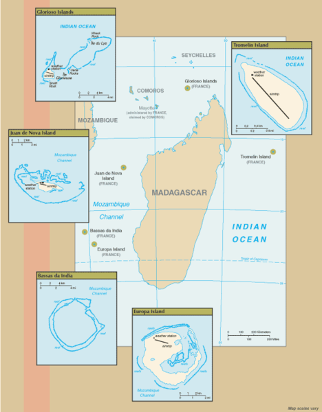
Miêu tả
New map of Iles Eparses from 7 Sept 06 rev. of the World Factbook: https://www.cia.gov/cia/publications/factbook/geos/zz.html archive copy at the Wayback Machine
Giấy phép
This image is in the public domain because it contains materials that originally came from the United States Central Intelligence Agency's World Factbook.
|
 |
Lịch sử tập tin
Nhấn vào ngày/giờ để xem nội dung tập tin tại thời điểm đó.
| Ngày/giờ | Hình xem trước | Kích cỡ | Thành viên | Miêu tả | |
|---|---|---|---|---|---|
| hiện tại | 16:07, ngày 8 tháng 9 năm 2006 | | 569×729 (27 kB) | Hoshie | ==Summary== New map of Iles Eparses from 7 Sept 06 rev. of the World Factbook: [https://www.cia.gov/cia/publications/factbook/geos/zz.html https://www.cia.gov/cia/publications/factbook/geos/zz.html] ==Licensing== {{PD-USGov-CIA-WF}} |
Trang sử dụng tập tin
Chưa có trang nào ở Wikipedia tiếng Việt liên kết đến tập tin này.
Sử dụng tập tin toàn cục
Những wiki sau đang sử dụng tập tin này:
- Trang sử dụng tại az.wikipedia.org
- Trang sử dụng tại en.wikipedia.org
- Trang sử dụng tại es.wikipedia.org
- Trang sử dụng tại fa.wikipedia.org
- Trang sử dụng tại fr.wikipedia.org
- Trang sử dụng tại fr.wiktionary.org
- Trang sử dụng tại gcr.wikipedia.org
- Trang sử dụng tại hi.wikipedia.org
- Trang sử dụng tại id.wikipedia.org
- Trang sử dụng tại ka.wikipedia.org
- Trang sử dụng tại ko.wikipedia.org
- Trang sử dụng tại lv.wikipedia.org
- Trang sử dụng tại mg.wikipedia.org
- Trang sử dụng tại pnb.wikipedia.org
- Trang sử dụng tại simple.wikipedia.org
- Trang sử dụng tại sr.wikipedia.org
- Trang sử dụng tại sv.wikipedia.org
- Trang sử dụng tại uk.wikipedia.org
- Trang sử dụng tại ur.wikipedia.org
- Trang sử dụng tại zh.wikipedia.org