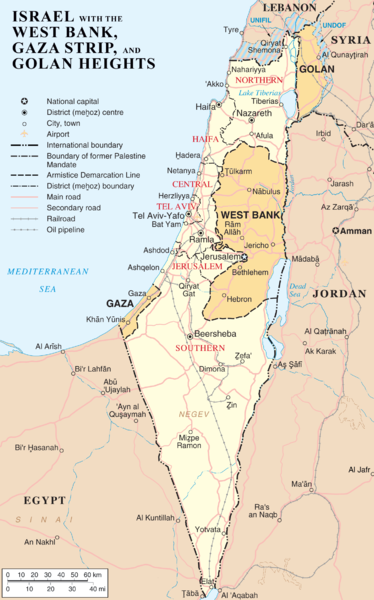
Tập tin:Is-wb-gs-gh v3.png

Kích thước hình xem trước: 374×600 điểm ảnh. Độ phân giải khác: 150×240 điểm ảnh | 299×480 điểm ảnh | 479×768 điểm ảnh | 639×1.024 điểm ảnh | 1.428×2.289 điểm ảnh.
Tập tin gốc (1.428×2.289 điểm ảnh, kích thước tập tin: 259 kB, kiểu MIME: image/png)
Lịch sử tập tin
Nhấn vào ngày/giờ để xem nội dung tập tin tại thời điểm đó.
| Ngày/giờ | Hình xem trước | Kích cỡ | Thành viên | Miêu tả | |
|---|---|---|---|---|---|
| hiện tại | 10:54, ngày 12 tháng 3 năm 2012 |  | 1.428×2.289 (259 kB) | Ayin leZion | Marked J'lem as capital according to en:Israel |
| 08:22, ngày 11 tháng 4 năm 2007 |  | 1.428×2.289 (259 kB) | Liftarn | {{Information |Description=Map of Israel, the Palestinian territories (West Bank and Gaza Strip), the Golan Heights, and portions of neighbouring countries. Also United Nations deployment areas in countries adjoining Israel or Israeli-held territory, as o |
Trang sử dụng tập tin
Có 2 trang tại Wikipedia tiếng Việt có liên kết đến tập tin (không hiển thị trang ở các dự án khác):
Sử dụng tập tin toàn cục
Những wiki sau đang sử dụng tập tin này:
- Trang sử dụng tại ar.wikipedia.org
- Trang sử dụng tại as.wikipedia.org
- Trang sử dụng tại be.wikipedia.org
- Trang sử dụng tại bg.wikipedia.org
- Trang sử dụng tại bn.wikipedia.org
- Trang sử dụng tại cs.wikipedia.org
- Trang sử dụng tại cv.wikipedia.org
- Trang sử dụng tại de.wikipedia.org
- Trang sử dụng tại dty.wikipedia.org
- Trang sử dụng tại en.wikipedia.org
- History of the Israeli–Palestinian conflict
- Isratin
- History of Palestine
- Palestinian rocket attacks on Israel
- User:Mr.Z-man/norefs
- User:Mr.Z-man/withrefs
- Wikipedia:Wikipedia Signpost/2014-07-30/Traffic report
- Wikipedia:Wikipedia Signpost/Single/2014-07-30
- Wikipedia:Top 25 Report/July 20 to 26, 2014
- Wikipedia:Top 25 Report/July 27 to August 2, 2014
- Wikipedia:Top 25 Report/August 3 to 9, 2014
- Talk:Israel/Archive 49
- Foreign policy of Donald Trump during the 2016 presidential election
- User:Falcaorib
- Trang sử dụng tại es.wikipedia.org
- Trang sử dụng tại fa.wikipedia.org
- Trang sử dụng tại fi.wikipedia.org
- Trang sử dụng tại fr.wikipedia.org
- Trang sử dụng tại hi.wikipedia.org
- Trang sử dụng tại hi.wiktionary.org
- Trang sử dụng tại hu.wikipedia.org
Xem thêm các trang toàn cục sử dụng tập tin này.


