
Tập tin:Krimpen IJssel 1867.gif

Tập tin gốc (1.600×1.371 điểm ảnh, kích thước tập tin: 174 kB, kiểu MIME: image/gif)
Tập tin này từ Wikimedia Commons. Trang miêu tả nó ở đấy được sao chép dưới đây. Commons là kho lưu trữ tập tin phương tiện có giấy phép tự do. Bạn có thể tham gia. |
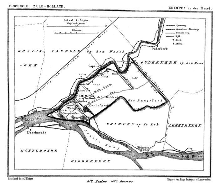
Miêu tả
| Miêu tả | Historic map of Krimpen aan den IJssel, the Netherlands |
| Ngày | giữa 1865 và 1870 |
| Nguồn gốc | Gemeente Atlas van Nederland (Municipal Atlas of the Netherlands) |
| Tác giả | J. Kuyper |
Giấy phép
|
Tác phẩm này thuộc về phạm vi công cộng tại quốc gia gốc và các quốc gia và vùng lãnh thổ có thời hạn bản quyền là cuộc đời tác giả cộng thêm 70 trở xuống.
| |
| Tập tin này đã được đánh dấu là không bị hạn chế dưới luật bản quyền, kể cả tất cả những quyền liên quan và lần cận. | |
Lịch sử tập tin
Nhấn vào ngày/giờ để xem nội dung tập tin tại thời điểm đó.
| Ngày/giờ | Hình xem trước | Kích cỡ | Thành viên | Miêu tả | |
|---|---|---|---|---|---|
| hiện tại | 17:31, ngày 15 tháng 3 năm 2007 | | 1.600×1.371 (174 kB) | P199 | {{Information |Description=Historic map of Krimpen aan den IJssel, the Netherlands |Source=Gemeente Atlas van Nederland (Municipal Atlas of the Netherlands) |Date=1865-1870 |Author=J. Kuyper |Permission= |other_versions= }} [[Category:Gemeente Atlas van |
| 17:25, ngày 15 tháng 3 năm 2007 |  | 1.600×1.371 (175 kB) | P199 | {{Information |Description=Historic map of Krimpen aan den IJssel, the Netherlands |Source=Gemeente Atlas van Nederland (Municipal Atlas of the Netherlands) |Date=1865-1870 |Author=J. Kuyper |Permission= |other_versions= }} [[Category:Gemeente Atlas van |
Trang sử dụng tập tin
Sử dụng tập tin toàn cục
Những wiki sau đang sử dụng tập tin này:
- Trang sử dụng tại de.wikipedia.org
- Trang sử dụng tại en.wikipedia.org
- Trang sử dụng tại fa.wikipedia.org
- Trang sử dụng tại fi.wikipedia.org
- Trang sử dụng tại fr.wikipedia.org
- Trang sử dụng tại id.wikipedia.org
- Trang sử dụng tại zh.wikipedia.org