
Tập tin:Map of Alabama NA.png

Kích thước hình xem trước: 776×600 điểm ảnh. Độ phân giải khác: 311×240 điểm ảnh | 621×480 điểm ảnh | 994×768 điểm ảnh | 1.280×989 điểm ảnh | 2.122×1.640 điểm ảnh.
Tập tin gốc (2.122×1.640 điểm ảnh, kích thước tập tin: 1,61 MB, kiểu MIME: image/png)
Tập tin này từ Wikimedia Commons. Trang miêu tả nó ở đấy được sao chép dưới đây. Commons là kho lưu trữ tập tin phương tiện có giấy phép tự do. Bạn có thể tham gia. |
Miêu tả
| Miêu tả |
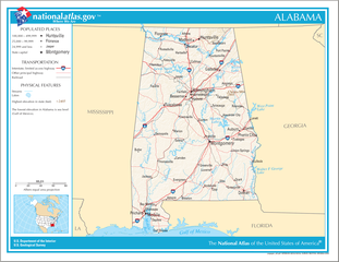
English: Map of the U.S. state of Alabama, with full legend area, copied from the National Atlas of the United States in high resolution form (1.61 megabytes). |
| Ngày | (uploaded on 14 tháng 8 năm 2006) |
| Nguồn gốc | |
| Tác giả | National Atlas of the United States (uploaded by User:Huebi) |
| Phiên bản khác |
The map has some related variations:
|
Giấy phép
This map was obtained from an edition of the National Atlas of the United States. Like almost all works of the U.S. federal government, works from the National Atlas are in the public domain in the United States.
Online access: NationalAtlas.gov | 1970 print edition: Library of Congress, Perry-Castañeda Library
|
Lịch sử tập tin
Nhấn vào ngày/giờ để xem nội dung tập tin tại thời điểm đó.
| Ngày/giờ | Hình xem trước | Kích cỡ | Thành viên | Miêu tả | |
|---|---|---|---|---|---|
| hiện tại | 20:08, ngày 14 tháng 8 năm 2006 | | 2.122×1.640 (1,61 MB) | Huebi~commonswiki | {{Information| |Description=Map of Alabama |Source=[http://www.nationalatlas.gov National Atlas] }} Category:Maps of the United States Category:Maps of Alabama {{PD-USGov-Atlas}} |
Trang sử dụng tập tin
Có 2 trang tại Wikipedia tiếng Việt có liên kết đến tập tin (không hiển thị trang ở các dự án khác):
Sử dụng tập tin toàn cục
Những wiki sau đang sử dụng tập tin này:
- Trang sử dụng tại als.wikipedia.org
- Trang sử dụng tại bs.wikipedia.org
- Trang sử dụng tại ca.wikipedia.org
- Trang sử dụng tại de.wikipedia.org
- Trang sử dụng tại en.wikipedia.org
- Trang sử dụng tại hi.wikipedia.org
- Trang sử dụng tại hr.wiktionary.org
- Trang sử dụng tại hsb.wikipedia.org
- Trang sử dụng tại hu.wikipedia.org
- Trang sử dụng tại ilo.wikipedia.org
- Trang sử dụng tại it.wikipedia.org
- Trang sử dụng tại ja.wikipedia.org
- Trang sử dụng tại ko.wikipedia.org
- Trang sử dụng tại no.wikipedia.org
- Trang sử dụng tại or.wikipedia.org
- Trang sử dụng tại simple.wikipedia.org
- Trang sử dụng tại si.wikipedia.org
- Trang sử dụng tại uz.wikipedia.org
- Trang sử dụng tại zea.wikipedia.org