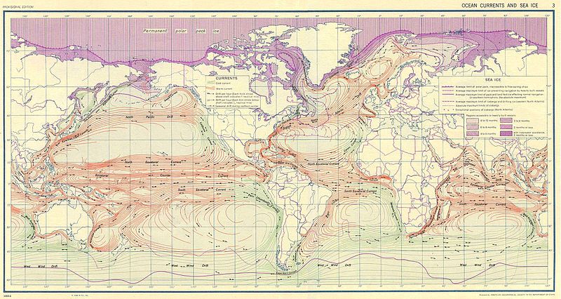
Tập tin:Ocean currents 1943.jpg

Kích thước hình xem trước: 800×426 điểm ảnh. Độ phân giải khác: 320×170 điểm ảnh | 640×341 điểm ảnh | 1.024×546 điểm ảnh | 1.280×682 điểm ảnh | 2.639×1.406 điểm ảnh.
Tập tin gốc (2.639×1.406 điểm ảnh, kích thước tập tin: 5,14 MB, kiểu MIME: image/jpeg)
Lịch sử tập tin
Nhấn vào ngày/giờ để xem nội dung tập tin tại thời điểm đó.
| Ngày/giờ | Hình xem trước | Kích cỡ | Thành viên | Miêu tả | |
|---|---|---|---|---|---|
| hiện tại | 10:58, ngày 6 tháng 9 năm 2016 |  | 2.639×1.406 (5,14 MB) | Dencey | new |
| 20:20, ngày 31 tháng 3 năm 2005 |  | 2.639×1.406 (582 kB) | SEWilco | '''Ocean Currents and Sea Ice from Atlas of World Maps.''' United States Army Service Forces, Army Specialized Training Division. Army Service Forces Manual M-101. 1943 {{PD-PCL}} Source: http://www.lib.utexas.edu/maps/world_maps/ocean_currents_ |
Trang sử dụng tập tin
Có 1 trang tại Wikipedia tiếng Việt có liên kết đến tập tin (không hiển thị trang ở các dự án khác):
Sử dụng tập tin toàn cục
Những wiki sau đang sử dụng tập tin này:
- Trang sử dụng tại bn.wikipedia.org
- Trang sử dụng tại cs.wikipedia.org
- Trang sử dụng tại de.wikipedia.org
- Trang sử dụng tại en.wikipedia.org
- Trang sử dụng tại eo.wikipedia.org
- Trang sử dụng tại es.wikipedia.org
- Trang sử dụng tại eu.wikipedia.org
- Trang sử dụng tại fr.wikipedia.org
- Trang sử dụng tại fr.wiktionary.org
- Trang sử dụng tại hu.wikipedia.org
- Trang sử dụng tại it.wikipedia.org
- Trang sử dụng tại ja.wikipedia.org
- Trang sử dụng tại lt.wikipedia.org
- Trang sử dụng tại nn.wikipedia.org
- Trang sử dụng tại oc.wikipedia.org
- Trang sử dụng tại pt.wiktionary.org
- Trang sử dụng tại sk.wikipedia.org
- Trang sử dụng tại sl.wikipedia.org
- Trang sử dụng tại sv.wikipedia.org
- Trang sử dụng tại tr.wikipedia.org
- Trang sử dụng tại zh.wikipedia.org


