
Tập tin:Qattara depression map.png
Qattara_depression_map.png (599×435 điểm ảnh, kích thước tập tin: 54 kB, kiểu MIME: image/png)
Tập tin này từ Wikimedia Commons. Trang miêu tả nó ở đấy được sao chép dưới đây. Commons là kho lưu trữ tập tin phương tiện có giấy phép tự do. Bạn có thể tham gia. |

|
Hình ảnh thuộc thể loại "locator map" cần được vẽ lại bằng đồ họa vector theo định dạng tập tin SVG. Để biết ưu điểm của định dạng này, hãy đọc Commons:Media for cleanup. Nếu tập tin này đã có SVG, xin hãy tải lên đây rồi thay bản mẫu này bằng {{vector version available|tên hình mới.svg}}.
|
| Miêu tả | |
| Ngày | 20 tháng 5 năm 2005 (ngày tải lên ban đầu) |
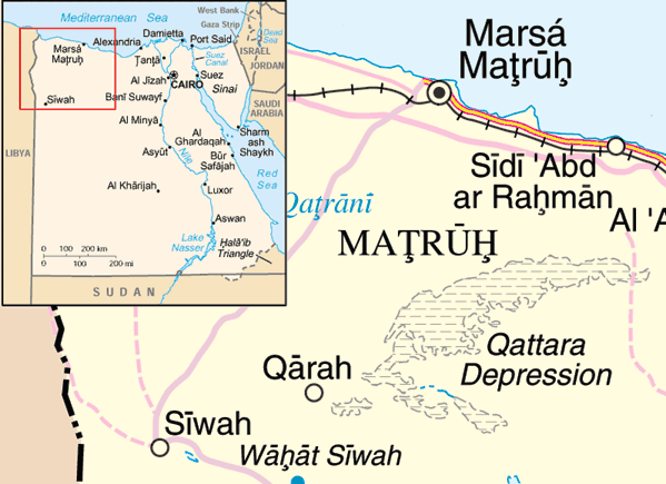
| Nguồn gốc | Adapted from https://www.un.org/geospatial/content/egypt and en:Image:Eg-map.png |
| Tác giả | The original uploader was ChrisO tại Wikipedia Tiếng Anh. |
Giấy phép
| This image is a map derived from a United Nations map.
Unless stated otherwise, UN maps are to be considered in the public domain. This applies worldwide. UN maps are, in principle, open source material and you can use them in your work or for making your own map. UN requests however that you delete the UN name, logo and reference number upon any modification to the map. Content of your map will be your responsibility. You can state in your publication, if you wish, something like: based on UN map … (map name, map number, revision number and date). See: Geospatial Information Section. And: Geospatial, location data for a better world. |
 |
Nhật trình tải lên đầu tiên
- 2005-05-20 22:10 ChrisO 599×435× (54888 bytes) Map of the [[Qattara Depression]], [[Egypt]] Adapted from http://www.un.org/Depts/Cartographic/map/profile/egypt.pdf and [[:Image:Eg-map.png]] {{UN map}}
Lịch sử tập tin
Nhấn vào ngày/giờ để xem nội dung tập tin tại thời điểm đó.
| Ngày/giờ | Hình xem trước | Kích cỡ | Thành viên | Miêu tả | |
|---|---|---|---|---|---|
| hiện tại | 12:29, ngày 31 tháng 3 năm 2009 | | 599×435 (54 kB) | File Upload Bot (Magnus Manske) | {{BotMoveToCommons|en.wikipedia|year={{subst:CURRENTYEAR}}|month={{subst:CURRENTMONTHNAME}}|day={{subst:CURRENTDAY}}}} {{Information |Description={{en|Map of the en:Qattara Depression, en:Egypt Adapted from http://www.un.org/Depts/Cartographic |
Trang sử dụng tập tin
Sử dụng tập tin toàn cục
Những wiki sau đang sử dụng tập tin này:
- Trang sử dụng tại ar.wikipedia.org
- Trang sử dụng tại arz.wikipedia.org
- Trang sử dụng tại cs.wikipedia.org
- Trang sử dụng tại da.wikipedia.org
- Trang sử dụng tại en.wikipedia.org
- Trang sử dụng tại eo.wikipedia.org
- Trang sử dụng tại es.wikipedia.org
- Trang sử dụng tại fa.wikipedia.org
- Trang sử dụng tại fi.wikipedia.org
- Trang sử dụng tại fr.wikipedia.org
- Trang sử dụng tại ga.wikipedia.org
- Trang sử dụng tại hr.wikipedia.org
- Trang sử dụng tại id.wikipedia.org
- Trang sử dụng tại ml.wikipedia.org
- Trang sử dụng tại my.wikipedia.org
- Trang sử dụng tại no.wikipedia.org
- Trang sử dụng tại uk.wikipedia.org
- Trang sử dụng tại ur.wikipedia.org
- Trang sử dụng tại war.wikipedia.org
- Trang sử dụng tại zh.wikipedia.org
- Trang sử dụng tại zu.wikipedia.org