
Tập tin:River Deltas, Lake Ayakum, Tibet.JPG

Kích thước hình xem trước: 800×532 điểm ảnh. Độ phân giải khác: 320×213 điểm ảnh | 640×425 điểm ảnh | 1.024×681 điểm ảnh | 1.280×851 điểm ảnh | 2.560×1.701 điểm ảnh | 4.288×2.850 điểm ảnh.
Tập tin gốc (4.288×2.850 điểm ảnh, kích thước tập tin: 2,74 MB, kiểu MIME: image/jpeg)
Tập tin này từ Wikimedia Commons. Trang miêu tả nó ở đấy được sao chép dưới đây. Commons là kho lưu trữ tập tin phương tiện có giấy phép tự do. Bạn có thể tham gia. |
Miêu tả
| Miêu tả |
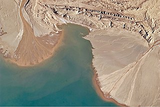
English: This astronaut photograph highlights two river deltas formed along Lake Ayakum's south-western shoreline. Gray to tan surfaces indicate prior positions of the river channels; the uniform coloration and smooth texture suggest that they are relatively old and now inactive. By contrast, the younger and currently active delta surfaces have reddish-brown sediment and visible river channels.
Lateral channel migration is particularly evident in the approximately 8-kilometer wide active delta at image upper left. The reddish color of the fresh sediment may indicate a change from the sources that formed the older parts of the deltas. It might indicate weathering and soil formation on the older deposits. It could even be a sign of episodic inputs of dust or other material to the river catchments. |
| Ngày | |
| Nguồn gốc | NASA Earth Observatory |
| Tác giả | ISS Expedition 27 crew |
| Vị trí máy chụp hình | | Xem hình này và các hình ảnh lân cận trên: OpenStreetMap |
|---|
This image or video was catalogued by Johnson Space Center of the United States National Aeronautics and Space Administration (NASA) under Photo ID: ISS027-E-16922. This tag does not indicate the copyright status of the attached work. A normal copyright tag is still required. See Commons:Licensing. Other languages:
|
Image acquired with a Nikon D2Xs digital camera using a 400 mm lens, and is provided by the ISS Crew Earth Observations experiment and Image Science & Analysis Laboratory, Johnson Space Center.
Giấy phép
| This file is in the public domain in the United States because it was solely created by NASA. NASA copyright policy states that "NASA material is not protected by copyright unless noted". (See Template:PD-USGov, NASA copyright policy page or JPL Image Use Policy.) | ||
 |
Warnings:
|
| Annotations | This image is annotated: View the annotations at Commons |
Lịch sử tập tin
Nhấn vào ngày/giờ để xem nội dung tập tin tại thời điểm đó.
| Ngày/giờ | Hình xem trước | Kích cỡ | Thành viên | Miêu tả | |
|---|---|---|---|---|---|
| hiện tại | 11:50, ngày 12 tháng 5 năm 2011 | | 4.288×2.850 (2,74 MB) | Originalwana | {{Information |Description ={{en|1=This astronaut photograph highlights two river deltas formed along Lake Ayakum's south-western shoreline. Gray to tan surfaces indicate prior positions of the river channels; the uniform coloration and smooth |
Trang sử dụng tập tin
Có 1 trang tại Wikipedia tiếng Việt có liên kết đến tập tin (không hiển thị trang ở các dự án khác):
Sử dụng tập tin toàn cục
Những wiki sau đang sử dụng tập tin này:
- Trang sử dụng tại ceb.wikipedia.org
- Trang sử dụng tại en.wikipedia.org
- Trang sử dụng tại es.wikipedia.org
- Trang sử dụng tại fa.wikipedia.org
- Trang sử dụng tại it.wikipedia.org
- Trang sử dụng tại pa.wikipedia.org