
Tập tin:South West England counties 2009 map.svg

Kích thước bản xem trước PNG này của tập tin SVG: 764×599 điểm ảnh. Độ phân giải khác: 306×240 điểm ảnh | 612×480 điểm ảnh | 979×768 điểm ảnh | 1.280×1.004 điểm ảnh | 2.560×2.008 điểm ảnh | 1.425×1.118 điểm ảnh.
Tập tin gốc (tập tin SVG, 1.425×1.118 điểm ảnh trên danh nghĩa, kích thước: 1,83 MB)
Tập tin này từ Wikimedia Commons. Trang miêu tả nó ở đấy được sao chép dưới đây. Commons là kho lưu trữ tập tin phương tiện có giấy phép tự do. Bạn có thể tham gia. |
Miêu tả
| Miêu tả |
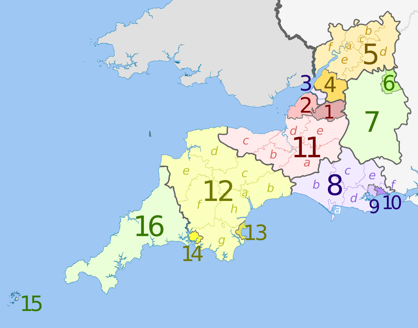
English: Map of the South West England region, showing its counties and administrative districts in 2009. The county colours are the same as those in File:English metropolitan and non-metropolitan counties 2009.svg.
For the districts since 1 April 2023, see File:South West England counties 2023 map.svg. Equirectangular map projection on WGS 84 datum, with N/S stretched 160% Geographic limits:
|
| Ngày | (UTC) |
| Nguồn gốc |
Là ảnh phái sinh từ: |
| Tác giả |
|
| Phiên bản khác | File:South West England counties 2023 map.svg – version since 1 April 2023 |

| Map | Ceremonial county | Shire county / unitary | Districts |
|---|---|---|---|
 |
Somerset | 1. Bath and North East Somerset UA | |
| 2. North Somerset UA | |||
| 11. Somerset CC | a) South Somerset, b) Taunton Deane, c) West Somerset, d) Sedgemoor, e) Mendip | ||
| 3. Bristol UA | |||
| Gloucestershire | 4. South Gloucestershire UA | ||
| 5. Gloucestershire CC | a) Gloucester, b) Tewkesbury, c) Cheltenham, d) Cotswold, e) Stroud, f) Forest of Dean | ||
| Wiltshire | 6. Swindon UA | ||
| 7. Wiltshire UA | |||
| Dorset | 8. Dorset CC | a) Weymouth and Portland, b) West Dorset, c) North Dorset, d) Purbeck, e) East Dorset, f) Christchurch | |
| 9. Poole UA | |||
| 10. Bournemouth UA | |||
| Devon | 12. Devon CC | a) Exeter, b) East Devon, c) Mid Devon, d) North Devon, e) Torridge, f) West Devon, g) South Hams, h) Teignbridge | |
| 13. Torbay UA | |||
| 14. Plymouth UA | |||
| Cornwall | 15. Isles of Scilly sui generis UA | ||
| 16. Cornwall UA | |||
UA = unitary authority CC = county council
Giấy phép
Tập tin này được phát hành theo Giấy phép Creative Commons Ghi công - Chia sẻ tương tự 3.0 Chưa chuyển đồi
Ghi công: Dr Greg and Nilfanion. Contains Ordnance Survey data © Crown copyright and database right 2011
- Bạn được phép:
- chia sẻ – sao chép, phân phối và chuyển giao tác phẩm
- pha trộn – để chuyển thể tác phẩm
- Theo các điều kiện sau:
- ghi công – Bạn phải ghi lại tác giả và nguồn, liên kết đến giấy phép, và các thay đổi đã được thực hiện, nếu có. Bạn có thể làm các điều trên bằng bất kỳ cách hợp lý nào, miễn sao không ám chỉ rằng người cho giấy phép ủng hộ bạn hay việc sử dụng của bạn.
- chia sẻ tương tự – Nếu bạn biến tấu, biến đổi, hoặc làm tác phẩm khác dựa trên tác phẩm này, bạn chỉ được phép phân phối tác phẩm mới theo giấy phép y hệt hoặc tương thích với tác phẩm gốc.
Nhật trình tải lên đầu tiên
This image is a derivative work of the following images:
- File:South_West_England_districts_2011_map.svg licensed with Cc-by-sa-3.0, GFDL
- 2011-05-01T19:06:01Z Nilfanion 1425x1118 (1924863 Bytes) == Summary == {{Information |Description=Map of the [[w:South West England|South West England]] region showing the administrative districts. Equirectangular map projection on WGS 84 datum, with N/S stretched 160% Geographic
- File:English_ceremonial_counties_2010.svg licensed with Cc-by-sa-3.0, GFDL
- 2010-11-23T16:39:55Z Nilfanion 1108x1345 (308868 Bytes) thicker lines
- 2010-11-23T16:20:19Z Nilfanion 1108x1345 (301520 Bytes) tweaks
- 2010-10-26T20:34:20Z Nilfanion 817x990 (1391832 Bytes) {{Information |Description=Map showing the [[w:ceremonial counties of England]] including the City of London, in 2010. Equirectangular map projection on WGS 84 datum, with N/S stretched 170% Geographic limits: *West: 6.75W
Uploaded with derivativeFX
Lịch sử tập tin
Nhấn vào ngày/giờ để xem nội dung tập tin tại thời điểm đó.
| Ngày/giờ | Hình xem trước | Kích cỡ | Thành viên | Miêu tả | |
|---|---|---|---|---|---|
| hiện tại | 20:07, ngày 5 tháng 5 năm 2012 | | 1.425×1.118 (1,83 MB) | Dr Greg | lighten black boundary line |
| 20:47, ngày 2 tháng 5 năm 2012 |  | 1.425×1.118 (1,83 MB) | Dr Greg | == {{int:filedesc}} == {{Information |Description={{en|Map of the South West England region, showing its counties and administrative districts. The county colours are the same as those in [[:File:English metropolitan and non-me... |
Trang sử dụng tập tin
Có 1 trang tại Wikipedia tiếng Việt có liên kết đến tập tin (không hiển thị trang ở các dự án khác):
Sử dụng tập tin toàn cục
Những wiki sau đang sử dụng tập tin này:
- Trang sử dụng tại ar.wikipedia.org
- Trang sử dụng tại fa.wikipedia.org
- Trang sử dụng tại fr.wikipedia.org
- Trang sử dụng tại ja.wikipedia.org
- Trang sử dụng tại mr.wikipedia.org
- Trang sử dụng tại pt.wikipedia.org
- Trang sử dụng tại tr.wikipedia.org
- Trang sử dụng tại vls.wikipedia.org
- Trang sử dụng tại zh-yue.wikipedia.org