
Tập tin:Soviet caucasus1922.png

Kích thước hình xem trước: 800×571 điểm ảnh. Độ phân giải khác: 320×229 điểm ảnh | 640×457 điểm ảnh | 1.024×731 điểm ảnh | 1.280×914 điểm ảnh | 1.613×1.152 điểm ảnh.
Tập tin gốc (1.613×1.152 điểm ảnh, kích thước tập tin: 127 kB, kiểu MIME: image/png)
Tập tin này từ Wikimedia Commons. Trang miêu tả nó ở đấy được sao chép dưới đây. Commons là kho lưu trữ tập tin phương tiện có giấy phép tự do. Bạn có thể tham gia. |
Miêu tả
| Miêu tả |
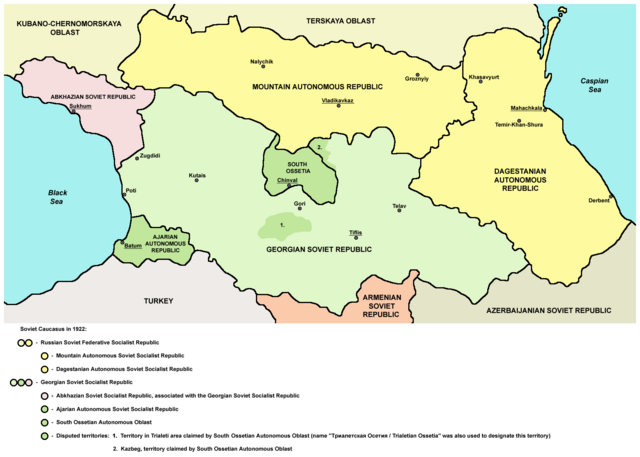
English: Northern part of Soviet Caucasus in 1922 - Mountain Autonomous Soviet Socialist Republic, Dagestanian Autonomous Soviet Socialist Republic, Georgian Soviet Socialist Republic, Abkhazian Soviet Socialist Republic, Ajarian Autonomous Soviet Socialist Republic, South Ossetian Autonomous Oblast and disputed territories claimed by South Ossetian Autonomous Oblast (Trialeti area / Trialetian Ossetia and Kazbeg). |
| Ngày | |
| Nguồn gốc | Tác phẩm được tạo bởi người tải lên |
| Tác giả | PANONIAN |
| Phiên bản khác |
|

Giấy phép
| Tôi, người giữ bản quyền của tác phẩm này, chuyển tác phẩm này vào phạm vi công cộng. Điều này có giá trị trên toàn thế giới. Tại một quốc gia mà luật pháp không cho phép điều này, thì: Tôi cho phép tất cả mọi người được quyền sử dụng tác phẩm này với bất cứ mục đích nào, không kèm theo bất kỳ điều kiện nào, trừ phi luật pháp yêu cầu những điều kiện đó. |
References
Made according to these sources:
- http://www.iriston.com/books/cuciev_-_etno_atlas/cuciev_etno-polit_map.htm - 50 maps from book "АТЛАС ЭТНОПОЛИТИЧЕСКОЙ ИСТОРИИ КАВКАЗА", Цуциев А.А, Москва: Издательство «Европа», 2007. ("Atlas of ethnopolitical history of Caucasus", Tsutsiev A.A, Moscow: Publisher «Evropa», 2007), inluding a map of Soviet Caucasus in 1921, which show Mountain Autonomous Soviet Socialist Republic, Dagestanian Autonomous Soviet Socialist Republic, Georgian Soviet Socialist Republic, Abkhazian Soviet Socialist Republic, Ajarian Autonomous Soviet Socialist Republic, and disputed territories inhabited by Ossetians: South Ossetia, Trialetian Ossetia and Kazbeg.
- http://dic.academic.ru/pictures/wiki/files/84/Tsutsiev.jpg - map from book "АТЛАС ЭТНОПОЛИТИЧЕСКОЙ ИСТОРИИ КАВКАЗА", Цуциев А.А ("Atlas of ethnopolitical history of Caucasus", Tsutsiev A.A), inluding a map of Soviet Caucasus in 1921, which show Mountain Autonomous Soviet Socialist Republic, Dagestanian Autonomous Soviet Socialist Republic, Georgian Soviet Socialist Republic, Abkhazian Soviet Socialist Republic, Ajarian Autonomous Soviet Socialist Republic, and disputed territories inhabited by Ossetians: South Ossetia, Trialetian Ossetia and Kazbeg.
- http://www.iriston.com/nogbon/pictures/Tabol/cuciev_karta_6.jpg - map of Soviet Caucasus in 1922, created by Tsutsiev A.A, which show Mountain Autonomous Soviet Socialist Republic and South Ossetian Autonomous Oblast.
Lịch sử tập tin
Nhấn vào ngày/giờ để xem nội dung tập tin tại thời điểm đó.
| Ngày/giờ | Hình xem trước | Kích cỡ | Thành viên | Miêu tả | |
|---|---|---|---|---|---|
| hiện tại | 17:03, ngày 26 tháng 12 năm 2015 | | 1.613×1.152 (127 kB) | PANONIAN | Reverted to version as of 14:47, 27 March 2010 (UTC) - please upload your version under different filename |
| 10:56, ngày 26 tháng 12 năm 2015 |  | 1.613×1.090 (115 kB) | Ercwlff | corrected georgian city names | |
| 10:45, ngày 26 tháng 12 năm 2015 |  | 1.613×1.090 (114 kB) | Ercwlff | corrected | |
| 10:42, ngày 26 tháng 12 năm 2015 |  | 1.613×1.090 (117 kB) | Ercwlff | ~~~~ | |
| 14:47, ngày 27 tháng 3 năm 2010 |  | 1.613×1.152 (127 kB) | PANONIAN | on the second thought, this map is focused on the history of Ossetians and other north Caucasian peoples and therefore disputes areas claimed by Armenia and Azerbaijan are not very relevant subject here | |
| 22:04, ngày 26 tháng 3 năm 2010 |  | 1.613×1.216 (134 kB) | PANONIAN | corrected one description | |
| 22:54, ngày 25 tháng 3 năm 2010 |  | 1.613×1.216 (132 kB) | PANONIAN | new version | |
| 23:52, ngày 23 tháng 3 năm 2010 |  | 1.613×1.122 (121 kB) | PANONIAN | correction | |
| 18:51, ngày 23 tháng 3 năm 2010 |  | 1.613×1.122 (121 kB) | PANONIAN | significant improvement - I hope that this is a final version | |
| 16:32, ngày 23 tháng 3 năm 2010 |  | 1.227×915 (88 kB) | PANONIAN | corrections |
Trang sử dụng tập tin
Có 1 trang tại Wikipedia tiếng Việt có liên kết đến tập tin (không hiển thị trang ở các dự án khác):
Sử dụng tập tin toàn cục
Những wiki sau đang sử dụng tập tin này:
- Trang sử dụng tại ar.wikipedia.org
- Trang sử dụng tại ast.wikipedia.org
- Trang sử dụng tại bg.wikipedia.org
- Trang sử dụng tại bn.wikipedia.org
- Trang sử dụng tại br.wikipedia.org
- Trang sử dụng tại ca.wikipedia.org
- Trang sử dụng tại ce.wikipedia.org
- Trang sử dụng tại de.wikipedia.org
- Trang sử dụng tại en.wikipedia.org
- Trang sử dụng tại eo.wikipedia.org
- Trang sử dụng tại es.wikipedia.org
- Trang sử dụng tại et.wikipedia.org
- Trang sử dụng tại fi.wikipedia.org
- Trang sử dụng tại fr.wikipedia.org
- Trang sử dụng tại it.wikipedia.org
- Trang sử dụng tại ja.wikipedia.org
- Trang sử dụng tại kk.wikipedia.org
- Trang sử dụng tại ko.wikipedia.org
- Trang sử dụng tại ku.wikipedia.org
- Trang sử dụng tại lt.wikipedia.org
- Trang sử dụng tại lv.wikipedia.org
- Trang sử dụng tại mk.wikipedia.org
- Trang sử dụng tại no.wikipedia.org
- Trang sử dụng tại os.wikipedia.org
- Trang sử dụng tại pl.wikipedia.org
Xem thêm các trang toàn cục sử dụng tập tin này.