
Tập tin:Tannenberg3008.jpg
Kích thước hình xem trước: 775×600 điểm ảnh. Độ phân giải khác: 310×240 điểm ảnh | 620×480 điểm ảnh | 993×768 điểm ảnh | 1.242×961 điểm ảnh.
Tập tin gốc (1.242×961 điểm ảnh, kích thước tập tin: 207 kB, kiểu MIME: image/jpeg)
Tập tin này từ Wikimedia Commons. Trang miêu tả nó ở đấy được sao chép dưới đây. Commons là kho lưu trữ tập tin phương tiện có giấy phép tự do. Bạn có thể tham gia. |

|
Hiện có một phiên bản với định dạng vector của hình này (SVG).
Nên sử dụng nó thay cho hình raster này khi cần nó chi tiết hơn. File:Tannenberg3008.jpg → File:East Prussian Campaign (27—30 Aug 1914) - ru.svg
Để biết thêm thông tin về đồ họa vector, mời đọc về Chuyển sang SVG của Commons. Cũng có thông tin về sự hỗ trợ hình ảnh SVG của MediaWiki. |
_-_ru.svg) |
| Miêu tả |
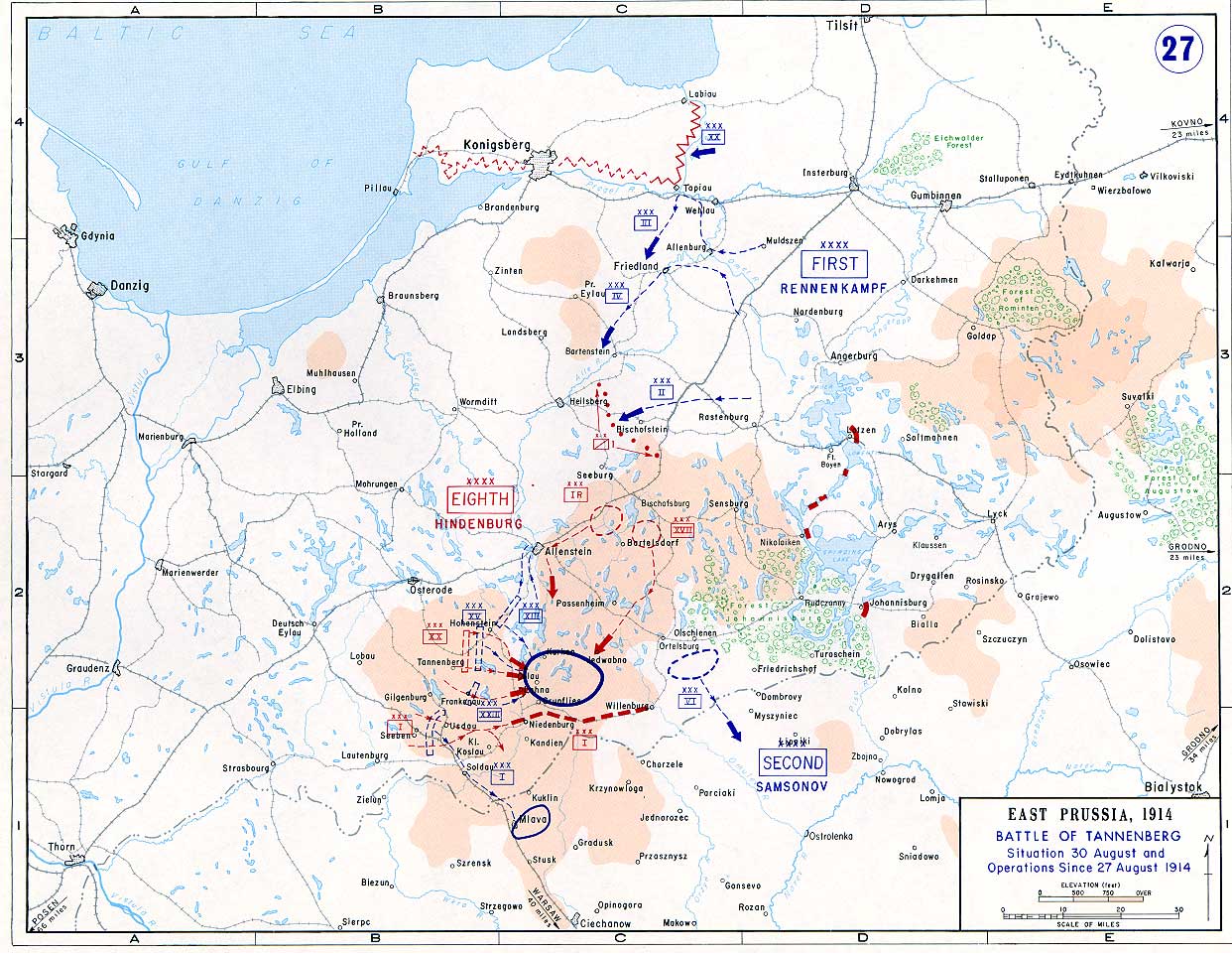
English: Battle of Tannenberg (1914) in its last phase |
| Nguồn gốc |
Taken from the campaign series, made public by the US-Army under dean.usma.edu
|
| Tác giả | US-Army under www.dean.usma.edu |
| Giấy phép (Dùng lại tập tin) |
The picture is public domain. |
Hình ảnh này là tác phẩm của binh sĩ hoặc nhân viên của Lục quân Hoa Kỳ, được chụp hoặc tạo ra khi đang làm nhiệm vụ. Là một tác phẩm của chính quyền liên bang Hoa Kỳ, hình ảnh hoặc tập tin này thuộc về phạm vi công cộng.
|
 |
Lịch sử tập tin
Nhấn vào ngày/giờ để xem nội dung tập tin tại thời điểm đó.
| Ngày/giờ | Hình xem trước | Kích cỡ | Thành viên | Miêu tả | |
|---|---|---|---|---|---|
| hiện tại | 14:29, ngày 22 tháng 9 năm 2005 | | 1.242×961 (207 kB) | Nasiruddin | Taken from the campaign series, made public by the US-Army under www.dean.usma.edu The öpicture is public domain. It shows the battle of Tannenberg in its last phase {{PD-USGov-Military-Army}} Category:World War I maps |
Trang sử dụng tập tin
Có 1 trang tại Wikipedia tiếng Việt có liên kết đến tập tin (không hiển thị trang ở các dự án khác):
Sử dụng tập tin toàn cục
Những wiki sau đang sử dụng tập tin này:
- Trang sử dụng tại be-tarask.wikipedia.org
- Trang sử dụng tại be.wikipedia.org
- Trang sử dụng tại ca.wikipedia.org
- Trang sử dụng tại cs.wikipedia.org
- Trang sử dụng tại da.wikipedia.org
- Trang sử dụng tại de.wikipedia.org
- Trang sử dụng tại el.wikipedia.org
- Trang sử dụng tại en.wikipedia.org
- Trang sử dụng tại et.wikipedia.org
- Trang sử dụng tại fi.wikipedia.org
- Trang sử dụng tại fr.wikipedia.org
- Trang sử dụng tại he.wikipedia.org
- Trang sử dụng tại hr.wikipedia.org
- Trang sử dụng tại it.wikipedia.org
- Trang sử dụng tại ja.wikipedia.org
- Trang sử dụng tại ko.wikipedia.org
- Trang sử dụng tại lv.wikipedia.org
- Trang sử dụng tại nl.wikipedia.org
- Trang sử dụng tại no.wikipedia.org
- Trang sử dụng tại pl.wikipedia.org
- Trang sử dụng tại sv.wikipedia.org
- Trang sử dụng tại uk.wikipedia.org
- Trang sử dụng tại zh.wikipedia.org