
Tập tin:The Dead Sea 1972-2011 - NASA Earth Observatory.jpg
Tập tin gốc (720×720 điểm ảnh, kích thước tập tin: 240 kB, kiểu MIME: image/jpeg)
Tập tin này từ Wikimedia Commons. Trang miêu tả nó ở đấy được sao chép dưới đây. Commons là kho lưu trữ tập tin phương tiện có giấy phép tự do. Bạn có thể tham gia. |
Miêu tả
| Miêu tả |
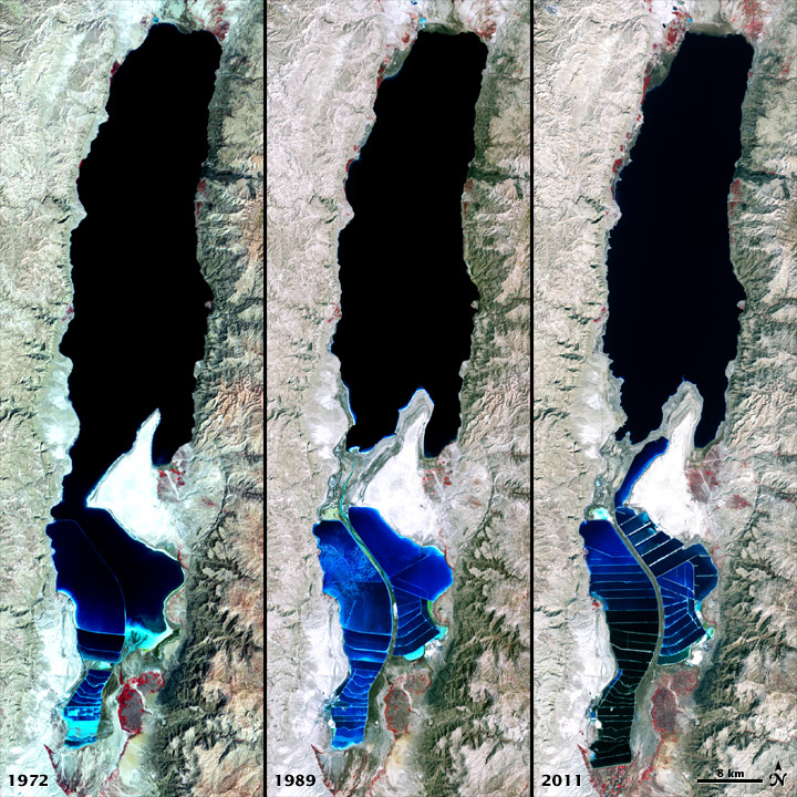
To download the full resolution and other files go to: earthobservatory.nasa.gov/IOTD/view.php?id=77592&src=... The Dead Sea is so named because its high salinity discourages the growth of fish, plants, and other wildlife. This salt lake resides in a depression in the Earth's crust, where the continents of Africa and Asia are pulling away from each other. It has pulled in visitors and industries for thousands of years. The Dead Sea is the lowest surface feature on Earth, sitting roughly 1,300 feet (400 meters) below sea level. On a hot, dry summer day, the water level can drop as much as one inch (two to three centimeters) because of evaporation. The false-color images above were captured by the Landsat 1, 4, and 7 satellites. The Multispectral Scanner System on Landsat 1 acquired the top image on September 15, 1972. The middle image was acquired on August 27, 1989, by the Thematic Mapper on Landsat 4. The third image is from the Enhanced Thematic Mapper Plus on Landsat 7 on October 11, 2011. All three images include a combination of near-infrared, red, and green wavelengths. Deep waters are blue or dark blue, while brighter blues indicate shallow waters or salt ponds (in the south). The pale pink and sand-colored regions are barren desert landscapes, while green indicates sparsely vegetated lands. Denser vegetation appears bright red. Near the center is the Lisan Peninsula, which forms a land bridge through the Dead Sea. The ancient Egyptians used salts from the Dead Sea for mummification, fertilizers, and potash (a potassium-based salt). In the modern age, sodium chloride and potassium salts culled from the sea are used for water conditioning, road de-icing, and the manufacturing of polyvinyl chloride (PVC) plastics. The expansion of massive salt evaporation projects are clearly visible over the span of 39 years. The region is also famous for its historical and religious significance. Between 1947 and 1956, a series of 972 ancient papyrus-and-ink texts were discovered in caverns near the sea’s northeastern shore. These “Dead Sea Scrolls” are some of the oldest preserved fragments of the Hebrew Bible and other Judeo-Christian texts. NASA and the U.S. Geological Survey (USGS) jointly manage Landsat, and the USGS preserves a 40-year archive of Landsat images that is freely available data over the Internet. The next Landsat satellite—now known as the Landsat Data Continuity Mission (LDCM)—is scheduled for launch in January 2013. NASA image by Robert Simmon, using Landsat data from the United States Geological Survey. Caption by Aries Keck and Mike Carlowicz. The Earth Observatory's mission is to share with the public the images, stories, and discoveries about climate and the environment that emerge from NASA research, including its satellite missions, in-the-field research, and climate models. Like us on Facebook Follow us on Twitter Add us to your circles on Google+ |
| Ngày | |
| Nguồn gốc | The Dead Sea 1972-2011 |
| Tác giả | NASA's Earth Observatory |
| Vị trí máy chụp hình | | Xem hình này và các hình ảnh lân cận trên: OpenStreetMap |
|---|
Giấy phép
- Bạn được phép:
- chia sẻ – sao chép, phân phối và chuyển giao tác phẩm
- pha trộn – để chuyển thể tác phẩm
- Theo các điều kiện sau:
- ghi công – Bạn phải ghi lại tác giả và nguồn, liên kết đến giấy phép, và các thay đổi đã được thực hiện, nếu có. Bạn có thể làm các điều trên bằng bất kỳ cách hợp lý nào, miễn sao không ám chỉ rằng người cho giấy phép ủng hộ bạn hay việc sử dụng của bạn.
| Hình này, ban đầu được tải lên tại Flickr bởi NASA Earth Observatory vào https://www.flickr.com/photos/68824346@N02/7050965693. Tập tin đã được FlickreviewR kiểm tra vào 2 tháng 7 năm 2012 và xác nhận rằng nó tuân theo các điều khoản của cc-by-2.0. |
Lịch sử tập tin
Nhấn vào ngày/giờ để xem nội dung tập tin tại thời điểm đó.
| Ngày/giờ | Hình xem trước | Kích cỡ | Thành viên | Miêu tả | |
|---|---|---|---|---|---|
| hiện tại | 17:06, ngày 2 tháng 7 năm 2012 | | 720×720 (240 kB) | Dzlinker | == {{int:filedesc}} == {{Information |Description=To download the full resolution and other files go to: [http://earthobservatory.nasa.gov/IOTD/view.php?id=77592&src=flickr earthobservatory.nasa.gov/IOTD/view.php?id=77592&src=...] The Dead Sea is so n... |
Trang sử dụng tập tin
Sử dụng tập tin toàn cục
Những wiki sau đang sử dụng tập tin này:
- Trang sử dụng tại af.wikipedia.org
- Trang sử dụng tại ar.wikipedia.org
- Trang sử dụng tại bg.wikipedia.org
- Trang sử dụng tại de.wikipedia.org
- Trang sử dụng tại en.wikipedia.org
- Trang sử dụng tại es.wikipedia.org
- Trang sử dụng tại fr.wikipedia.org
- Trang sử dụng tại he.wikipedia.org
- Trang sử dụng tại hy.wikipedia.org
- Trang sử dụng tại hyw.wikipedia.org
- Trang sử dụng tại nl.wikipedia.org
- Trang sử dụng tại ro.wikipedia.org
- Trang sử dụng tại sl.wikipedia.org
- Trang sử dụng tại tr.wikipedia.org
- Trang sử dụng tại uk.wikipedia.org