
Tập tin:Titan 2009-01 ISS polar maps.jpg
Tập tin gốc (1.884×942 điểm ảnh, kích thước tập tin: 510 kB, kiểu MIME: image/jpeg)
Tập tin này từ Wikimedia Commons. Trang miêu tả nó ở đấy được sao chép dưới đây. Commons là kho lưu trữ tập tin phương tiện có giấy phép tự do. Bạn có thể tham gia. |
Miêu tả
| Miêu tả |
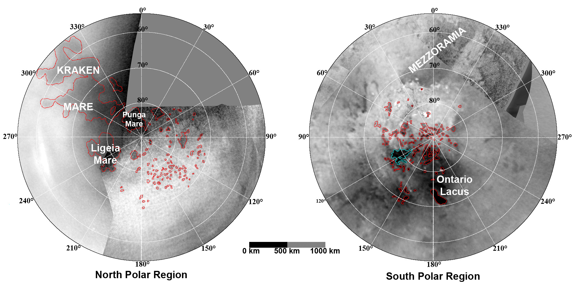
English: These updated maps of Saturn’s moon Titan, consisting of data from the Cassini Imaging Science Subsystem, include Cassini's August 2008 images of the moon's north polar region.
Evidence from Cassini's Imaging Science Subsystem, RADAR, and Visual and Infrared Mapping Spectrometer instruments strongly suggests that dark areas near the poles are lakes of liquid hydrocarbons like ethane or methane -- an analysis affirmed by images capturing changes in the lakes thought to be brought on by rainfall. Colored lines in the polar portions of these maps illustrate the boundaries between surface regions having different albedos -- or differences in surface brightness -- which Cassini scientists have interpreted as potential shorelines. Blue outlines indicate features that changed between observations made one year apart (see PIA11147). The map at left is a north polar projection showing latitudes 55 degrees to 90 degrees. The right map is a south polar projection showing latitudes minus qq55 degrees to minus 90 degrees. The maps are compiled from images dating from April 2004 through August 2008, and their resolutions vary from several hundred meters to a few tens of kilometers. Brightness variations are due to differences in surface albedo rather than topographic shading. The original NASA map of Titan has been cropped to show only the polar regions.Deutsch: Oberflächenkarte der beiden Pole, erstellt aus Daten des Cassini Imaging Science Subsystems, Januar 2009. |
| Ngày | |
| Nguồn gốc | File:TitanMapJan2009.jpg, http://photojournal.jpl.nasa.gov/catalog/PIA11146 |
| Tác giả | NASA/JPL/Space Science Institute |
| Phiên bản khác |
http://photojournal.jpl.nasa.gov/catalog/PIA11146
|

Giấy phép
Hình này thuộc phạm vi công cộng tại Hoa Kỳ vì nó là của Cục Quản lý Khí quyển và Đại dương Quốc gia Hoa Kỳ, được tạo ra trong quá trình công tác chính thức của nhân viên.
|
Lịch sử tập tin
Nhấn vào ngày/giờ để xem nội dung tập tin tại thời điểm đó.
| Ngày/giờ | Hình xem trước | Kích cỡ | Thành viên | Miêu tả | |
|---|---|---|---|---|---|
| hiện tại | 23:26, ngày 7 tháng 8 năm 2010 | | 1.884×942 (510 kB) | LobStoR | improved quality |
| 11:26, ngày 31 tháng 1 năm 2009 |  | 1.884×944 (499 kB) | WolfmanSF | {{Information |Description={{en|1=These updated maps of Saturn’s moon Titan, consisting of data from the Cassini Imaging Science Subsystem, include Cassini's August 2008 images of the moon's north polar region. Evidence from Cassini's Imaging Science S |
Trang sử dụng tập tin
Sử dụng tập tin toàn cục
Những wiki sau đang sử dụng tập tin này:
- Trang sử dụng tại an.wikipedia.org
- Trang sử dụng tại ar.wikipedia.org
- Trang sử dụng tại be.wikipedia.org
- Trang sử dụng tại de.wikipedia.org
- Trang sử dụng tại en.wikipedia.org
- Trang sử dụng tại en.wikiversity.org
- Trang sử dụng tại fr.wikipedia.org
- Trang sử dụng tại hy.wikipedia.org
- Trang sử dụng tại id.wikipedia.org
- Trang sử dụng tại ja.wikipedia.org
- Trang sử dụng tại lb.wikipedia.org
- Trang sử dụng tại mk.wikipedia.org
- Trang sử dụng tại no.wikipedia.org
- Trang sử dụng tại ro.wikipedia.org
- Trang sử dụng tại ru.wikipedia.org
- Trang sử dụng tại uk.wikipedia.org
- Trang sử dụng tại zh.wikipedia.org