
Tập tin:Zalzala Jazeera 2013 Gwadar.jpg
Không có độ phân giải cao hơn.
Zalzala_Jazeera_2013_Gwadar.jpg (720×480 điểm ảnh, kích thước tập tin: 94 kB, kiểu MIME: image/jpeg)
Tập tin này từ Wikimedia Commons. Trang miêu tả nó ở đấy được sao chép dưới đây. Commons là kho lưu trữ tập tin phương tiện có giấy phép tự do. Bạn có thể tham gia. |
Miêu tả
| Miêu tả |
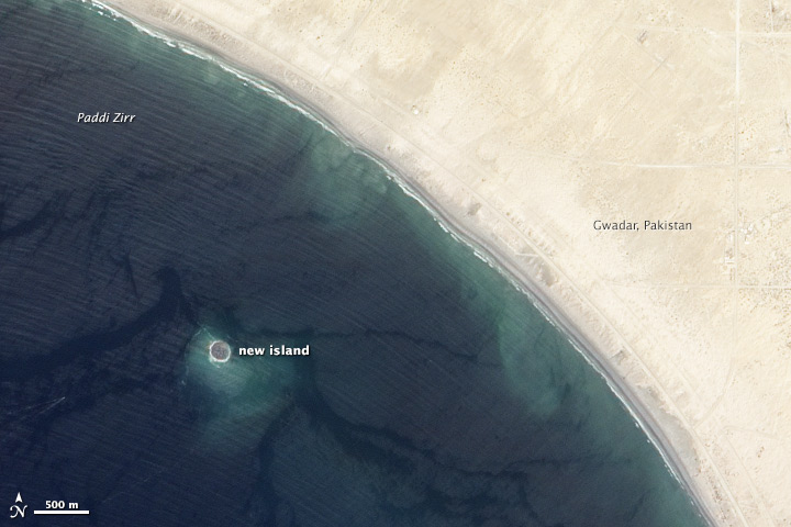
English: Zalzala Jazeera (Earthquake Island) appears near the center of this image of the bay west of Gwadar, Pakistan.
On September 26, 2013, the Advanced Land Imager (ALI) on NASA’s Earth Observing-1 (EO-1) satellite captured the top image of that new island, which sits roughly one kilometer (0.6 miles) offshore. Likely a “mud volcano,” the island rose from the seafloor near Gwadar on September 24, shortly after the earthquake struck about 380 kilometers (230 miles) inland. File:Gwadar satellite view.jpg, acquired by the Operational Land Imager on the Landsat 8 satellite, shows the same area on April 17, 2013. In the satellite images, lighter shades of green and tan in the water reveal shallow seafloor or suspended sediment. The water depth around the new island is roughly 15 to 20 meters, according to marine geologist Asif Inam of Pakistan’s National Institute of Oceanography. “The floor in that area is generally flat, but the gradient in this area changes quite abruptly,” Inam said. The top image from ALI is also clear enough to show the parallel ripples of waves marching toward the shore. |
| Ngày | |
| Nguồn gốc | http://earthobservatory.nasa.gov/NaturalHazards/view.php?id=82146 |
| Tác giả | NASA |
| Phiên bản khác |
 |
| Vị trí máy chụp hình | | Xem hình này và các hình ảnh lân cận trên: OpenStreetMap |
|---|
Giấy phép
| This file is in the public domain in the United States because it was solely created by NASA. NASA copyright policy states that "NASA material is not protected by copyright unless noted". (See Template:PD-USGov, NASA copyright policy page or JPL Image Use Policy.) | ||
 |
Warnings:
|
Lịch sử tập tin
Nhấn vào ngày/giờ để xem nội dung tập tin tại thời điểm đó.
| Ngày/giờ | Hình xem trước | Kích cỡ | Thành viên | Miêu tả | |
|---|---|---|---|---|---|
| hiện tại | 01:33, ngày 28 tháng 9 năm 2013 | | 720×480 (94 kB) | Rehman | official nasa crop |
| 01:18, ngày 28 tháng 9 năm 2013 |  | 459×486 (30 kB) | Ke4roh | User created page with UploadWizard |
Trang sử dụng tập tin
Có 1 trang tại Wikipedia tiếng Việt có liên kết đến tập tin (không hiển thị trang ở các dự án khác):
Sử dụng tập tin toàn cục
Những wiki sau đang sử dụng tập tin này:
- Trang sử dụng tại ar.wikipedia.org
- Trang sử dụng tại as.wikipedia.org
- Trang sử dụng tại az.wikipedia.org
- Trang sử dụng tại bn.wikipedia.org
- Trang sử dụng tại ca.wikipedia.org
- Trang sử dụng tại cs.wikipedia.org
- Trang sử dụng tại el.wikipedia.org
- Trang sử dụng tại en.wikipedia.org
- Trang sử dụng tại es.wikipedia.org
- Trang sử dụng tại fa.wikipedia.org
- Trang sử dụng tại fi.wikipedia.org
- Trang sử dụng tại fr.wikipedia.org
- Trang sử dụng tại id.wikipedia.org
- Trang sử dụng tại incubator.wikimedia.org
- Trang sử dụng tại it.wikipedia.org
- Trang sử dụng tại ja.wikipedia.org
- Trang sử dụng tại nl.wikipedia.org
- Trang sử dụng tại pnb.wikipedia.org
- Trang sử dụng tại ru.wikipedia.org
- Trang sử dụng tại scn.wikipedia.org
- Trang sử dụng tại sd.wikipedia.org
- Trang sử dụng tại simple.wikipedia.org
- Trang sử dụng tại sr.wikipedia.org
- Trang sử dụng tại tr.wikipedia.org
- Trang sử dụng tại uk.wikipedia.org
- Trang sử dụng tại ur.wikipedia.org
- Trang sử dụng tại www.wikidata.org